"Largest book in the world" to be displayed for the first time

For free real time breaking news alerts sent straight to your inbox sign up to our breaking news emails
Sign up to our free breaking news emails
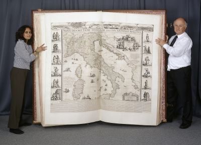
The British Library announced January 26 that it will display the "largest book in the world" for the first time to the general public as part of its summer exhibition Magnificent Maps: Power, Propaganda and Art. Measuring in at nearly six feet (1.8 meters) tall, the book is a 1660 atlas made for Charles II of England.
Johan Maurits of Nassau is credited with creating The Klencke Atlas, which Amsterdam merchant Johannes Klencke apparently presented to Charles II of England upon the king's restoration to the throne in 1660. The book is a collection of 37 printed wall maps in an ornate 1.75x1.9m binding, and was said to encapsulate all the geographic and historical knowledge of the time. All the included maps are either unique or one of only a few copies.
Magnificent Maps: Power, Propaganda and Art is at the British Library in London from April 30 to September 19. Admission is free. The exhibition will feature 100 maps from around the world, including many wall maps that will be shown for the first time.
http://www.bl.uk/magnificentmaps
Subscribe to Independent Premium to bookmark this article
Want to bookmark your favourite articles and stories to read or reference later? Start your Independent Premium subscription today.
Join our commenting forum
Join thought-provoking conversations, follow other Independent readers and see their replies