Four photos reveal terrifying speed of Dixie fire as it grows to six times size of San Francisco
Fueled by the effects of climate change, the Dixie and Fly fires have merged to create the 15th largest wildfire in California history

Sign up to the Independent Climate email for the latest advice on saving the planet
Get our free Climate email
The four photos taken just four minutes apart show the devastating speed at which wildfires in California are tearing through dry woodland.
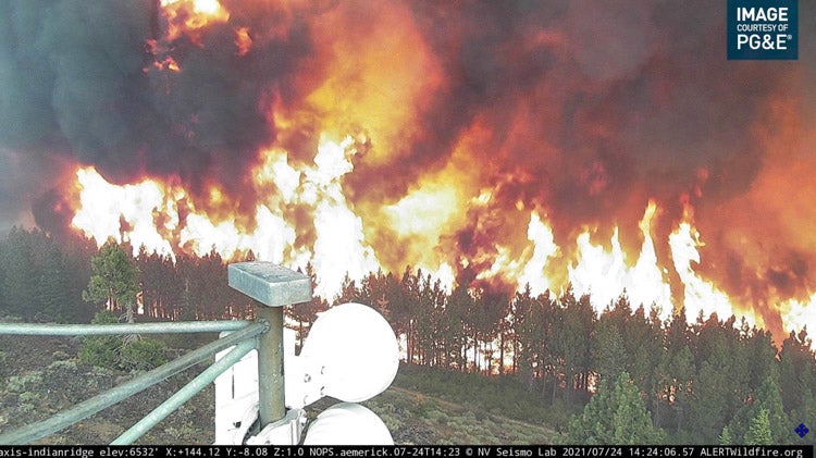
Taken from a specialist wildfire camera on Indian Ridge, just north of the town of Keddie in the Sierra Nevada mountains, they show the Fly Fire enveloping several acres of parched forest, spurred on by searing heat and high winds on Saturday afternoon.
Within minutes, the fire has destroyed everything in its path: another photo taken less than two hours later shows the barren, charred landscape.
On Saturday, California’s largest active blaze, the Dixie Fire, merged with the Fly Fire as the both continued its relentless march across the north of the state.
Combined, they have already torched an area six times the size of San Francisco.
The wildfire, already the 15th largest ever in California, had scorched 192,000 acres of timber and brush across Butte and Plumas counties north of Sacramento by Sunday night, according to Cal Fire deputy chief Jonathan Cox.
The vast blaze has destroyed 16 homes, is threatening 10,000 more, and prompted evacuation orders in several small resort towns along Lake Almanor.
An evacuation shelter was established in the city of Susanville, and five other areas were placed under evacuation warnings, Reuters reported.
California’s Office of Emergency Services said more than 7,400 people had been evacuated from Plumas County, and a further 100 from Dixie County.
On Sunday, a vast smoke column from the blaze created a “temperature inversion”, which cooled the fire and temporarily helped to slow its spread, meteorologist Julia Rutherford told Plumas News.
That and the lighter winds meant the Dixie and Fly fires combined destroyed around 2000 acres on Sunday, significantly less than Saturday.
“The smoke turned out to be our friend,” Ms Rutherford told Plumas News.
The thick smoke caused the skies above northern California to turn deep red.
(iPhone pic) Darkest fire I’ve ever seen. Hearing this is directly under a 15k foot smoke column. It’s also 93 degrees. #DixieFire pic.twitter.com/QVLzxOgKB1
— Josh Edelson (@JoshEdelson) July 24, 2021
The rugged terrain is complicating firefighting efforts, and the blaze is only 21% contained, Cal Fire reported on Sunday evening.
California Department of Forestry and Fire Protection spokesman Rick Carhart told PA News firefighters were hiking through the woodlands with hand tools in areas their vehicles were unable to reach.
“It has been burning in extremely steep canyons, some places where it is almost impossible for human beings to set foot on the ground to get in there,” Mr Carhart told PA News.
“It’s going to be a long haul.”
On Monday, southwest winds were expected to clear the thick blanket of smoke around midday.
“It’s another day with pretty critical conditions,” Rutherford told Plumas News.
The cause of the blaze is still under investigation, but meteorologists and firefighters say the arid conditions caused by record temperatures and lower than average rainfall have helped to fuel it.
Governor Gavin Newsom declared a state of emergency for four northern counties due to the wildfires, which frees up greater funding and relief measures from the state. He said they were causing “conditions of extreme peril to the safety of persons and property”.
Some 22,000 firefighters are tackling more than 80 active blazes across the western United States, which have burned through over 1.4 million acres.
Elsewhere in California, the Tamarack Fire south of Lake Tahoe has grown to an area of 104 square miles as it continues to imperil towns along the border of California and Nevada.
The fire was sparked by a lightning strike on July 4 in Alpine County, California, and has so far has destroyed at least 23 buildings, including more than a dozen in Nevada. It was 27% contained on Sunday, and officials were able to lift evacuation orders.
Oregon governor Kate Brown told CNN’s State of the Union that it is imperative federal and state authorities invest in mitigation measures such as tree thinning and preventive burns to limit the number of similar massive blazes.
Subscribe to Independent Premium to bookmark this article
Want to bookmark your favourite articles and stories to read or reference later? Start your Independent Premium subscription today.
Join our commenting forum
Join thought-provoking conversations, follow other Independent readers and see their replies