TfL releases ‘walk the Tube’ map showing number of steps between London stations
TfL says the map was released in order to encourage Londoners to take part in daily exercise and get fit

Get the free Morning Headlines email for news from our reporters across the world
Sign up to our free Morning Headlines email
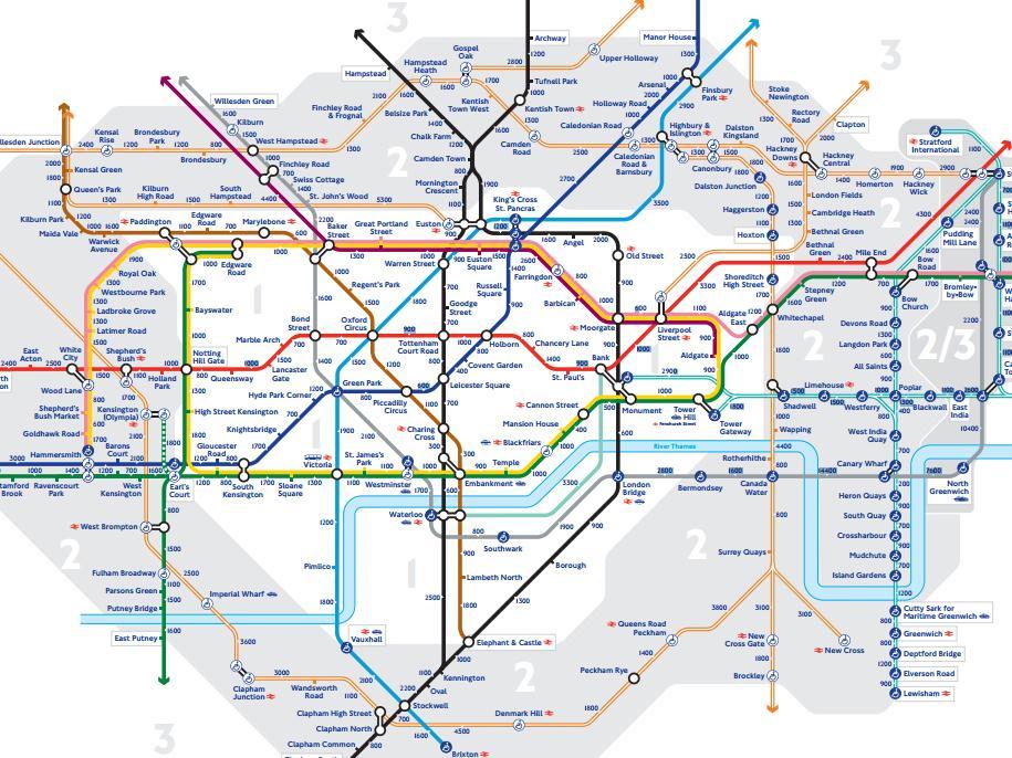
Transport for London (TfL) has unveiled its first official map showing how many steps it takes to walk between London’s Tube stations.
The map shows Leicester Square and Covent Garden are only 400 steps apart from each other, while the walk from Kings Cross to Euston takes 1,200 steps.
TfL said the map was released in order to encourage Londoners to take part in daily exercise and get fit.
The organisation says it aims to increase the proportion of adults in London who walk or cycle for 20 minutes a day from a current figure of around 35 per cent to 70 per cent by 2050.
Sadiq Khan has described the map as a fun and practical way to help busy Londoners who want to make walking part of their everyday lives.
The London Mayor has previously made a commitment to get more Londoners walking, and is in the process of appointing a new Walking and Cycling Commissioner in City Hall.
Mr Khan said: “We need to make it easier and more enjoyable to walk around London. We all hop on the Tube to take short journeys around central London, whether for work or when we’re out in the evening.
“The new steps map will encourage more of us to walk these short journeys instead – it’s good for our health and it will help support London’s small businesses. We’ve made clear our commitment to tackle air pollution and get more walking and cycling in London.”
Ben Plowden, Director of Surface Strategy and Planning at TfL, said: “People often use the Tube map to navigate the city, but many don’t realise just how close some stations are to each other and that they could save time as well as build more physical activity into their daily routine.
“We hope that the new steps version of the Tube map will inspire people to try new routes and discover that places in central London are closer than they might think.”
The latest “walk the Tube” map follows a previously released one last year showing how many minutes it takes to walk between stations.
You can view the full map here.
Subscribe to Independent Premium to bookmark this article
Want to bookmark your favourite articles and stories to read or reference later? Start your Independent Premium subscription today.
Join our commenting forum
Join thought-provoking conversations, follow other Independent readers and see their replies