Grass found growing around Mount Everest as warming climate melts ice
Increase in vegetation could play role in region’s water supply, which reaches 1.4 billion people

Sign up to the Independent Climate email for the latest advice on saving the planet
Get our free Climate email
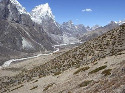
Grasses and shrubs have been found growing in increased numbers around Mount Everest and across the Himalayas as ice in the area continues to melt.
Scientists used satellite data to study the proliferation of subnival vegetation – plants which grow between the treeline and snowline – in the vast region.
By studying images taken by Nasa‘s Landsat satellites between 1993 and 2018, they found a small but significant increase in vegetation across four height brackets from 4,150 to 6,000m above sea level.
“A lot of research has been done on ice melting in the Himalayan region, including a study that showed how the rate of ice loss doubled between 2000 and 2016,” said Dr Karen Anderson, of the Environment and Sustainability Institute on Exeter’s Penryn Campus in Cornwall.
“It’s important to monitor and understand ice loss in major mountain systems, but subnival ecosystems cover a much larger area than permanent snow and ice and we know very little about them and how they moderate water supply.”
Rubbish mountain: Everest waste piles up
Show all 10While the study, published in Global Change Biology, did not examine the causes of the change, the researchers said their findings were consistent with modelling showing a decline in “temperature-limited areas” – where temperatures are too low for plants to grow – due to global warming.
Dr Anderson said the increase in subnival vegetation could play a role in the region’s water supply, which feeds Asia’s 10 largest rivers and supplies up to 1.4 billion people.
“Snow falls and melts here seasonally, and we don’t know what impact changing subnival vegetation will have on this aspect of the water cycle – which is vital because this region, known as ‘Asia’s water towers’, feeds the 10 largest rivers in Asia,” she said.
She said “some really detailed fieldwork” was required to understand how plants in the high-altitude zone interact with soil and snow.
Dominic Fawcett, who coded the image processing, said: “These large-scale studies using decades of satellite data are computationally intensive because the file sizes are huge.
“We can now do this relatively easily on the cloud by using Google Earth Engine, a new and powerful tool freely available to anyone, anywhere.”
Subscribe to Independent Premium to bookmark this article
Want to bookmark your favourite articles and stories to read or reference later? Start your Independent Premium subscription today.
Join our commenting forum
Join thought-provoking conversations, follow other Independent readers and see their replies