This Devon trail has definitely got the Exe factor
Walk of the Month: Beautiful farmland, ancient oak woods, wild ponies, and red deer. Mark Rowe steps out in Exmoor

Sign up to Simon Calder’s free travel email for expert advice and money-saving discounts
Get Simon Calder’s Travel email
High moorland, steep-sided, deep river valleys and secluded woodlands characterise Exmoor, and this lengthy walk takes in all these elements, striking out from one of the national park's charming towns.
The walk starts in the centre of Dulverton, where you make your way up Fore Street and take the steps to the side of the church (look for the 13th-century tower) and then turn left along the lane that cuts across at a T-junction. The path winds uphill steeply, and soon you are high above Dulverton.
The path levels out and the route follows a track for a mile, passing a sign to the left to Marsh Bridge. Keep ahead to a gate and follow the waymarkers to the right of gorse bushes where the path forks. Keep ahead until you reach a paved road, where you turn left and follow this lane, sweeping round to the right. After half a mile bear half left, following blue waymarkers into a field and keep to the left-hand field edge past Highercombe Farm.
Pass through a gate beyond the farm, take the track downhill ahead to the road and bear right for half a mile until you come to a cattle grid. Cross over and drop downhill along the road. This is Winsford Hill – wilder, grazed by ponies, the real heart of Exmoor, and a place to savour.
Bear left, following the signpost for Tarr Steps, cross another cattle grid and bear half left along the track, off the road, making again for Tarr Steps. Go through a gate and keep ahead along the thin path for a mile and drop down steeply through woodlands to reach Tarr Steps by the River Barle, a major tributary of the River Exe.
There's a tea house here, and the benches by the river make a pleasant place to pause. Tarr Steps is, in fact, a clapper bridge, made from 17 unmortared granite slabs, each weighing about five tons, and is thought to be the longest of its kind in Britain.
The walk continues across the bridge, bearing left and then immediately taking the track uphill to the right. Follow the blue waymarkers as the path winds uphill, where you enter a field, keep to the right-hand edge and then bear left, still with the edge to your right. Pass through a gate, over a hill and drop down the path to Parsonage Farm. Here, it is worth taking a short detour around the nature trail. The waymarked track winds down through farmland and takes less than 10 minutes, but you have an excellent chance of seeing red deer. The path ends a few metres downhill from where you left the track.
Continue downhill, following the path as it sweeps left, now high above the river. At a crossroads with a paved road, go straight ahead into a field and keep ahead, following signs for Hawkridge. Follow the path around the back of some houses on to the lane and turn left. Keep straight ahead, the lane becoming a track, ignoring the road sign to Dulverton, which points in the other direction.
The path now drills south-east along a ridge, following the Exe Valley Way (though you actually walk above the Barle valley). Again, the views are those of classic Exmoor. After 200 metres, take the right-hand path through gorse and a gate to drop down to the river.
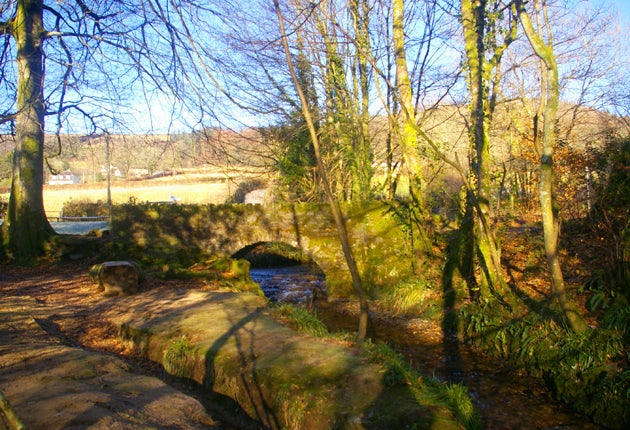
Cross over Castle Bridge and, now on the right-hand bank, follow the course of the river through ancient oak woods for two miles. When you come to Marsh Bridge, turn right uphill and then go straight ahead through a gate where the road bears right, past houses to pick up the path back to Dulverton. At the time of writing, a landslide required a waymarked detour on a parallel path in the woods above the river. As you approach Dulverton, the path drops down to the graceful five-arched bridge to re-enter the village.
While walking this route, the river was in full spate. Back in Dulverton, there is a sobering high water mark, recording the rainfall of August 1952 that flooded Dulverton and devastated Lynmouth to the north.
Compact Facts
Distance: 12 miles
Time: 4-5 hours
OS MAP: Explorer OL9 Exmoor
Further information
Mark Rowe stayed, courtesy of Cascade Cottage, at Edgcott House (01643 831164; edgcotthouse.co.uk), which offers B&B and self-catering accommodation. For more information about things to see and do on Exmoor, go to visit-exmoor.co.uk.
Subscribe to Independent Premium to bookmark this article
Want to bookmark your favourite articles and stories to read or reference later? Start your Independent Premium subscription today.
Join our commenting forum
Join thought-provoking conversations, follow other Independent readers and see their replies