
Sign up to Simon Calder’s free travel email for expert advice and money-saving discounts
Get Simon Calder’s Travel email
Being part of a national park can be something of a mixed blessing. While this coveted status brings in much-needed funding, it also requires villages to commit to what can be an onerous investment in infrastructure and to sign up to what you might call the "chocolate box" charter – prettifying themselves to draw the punters in.
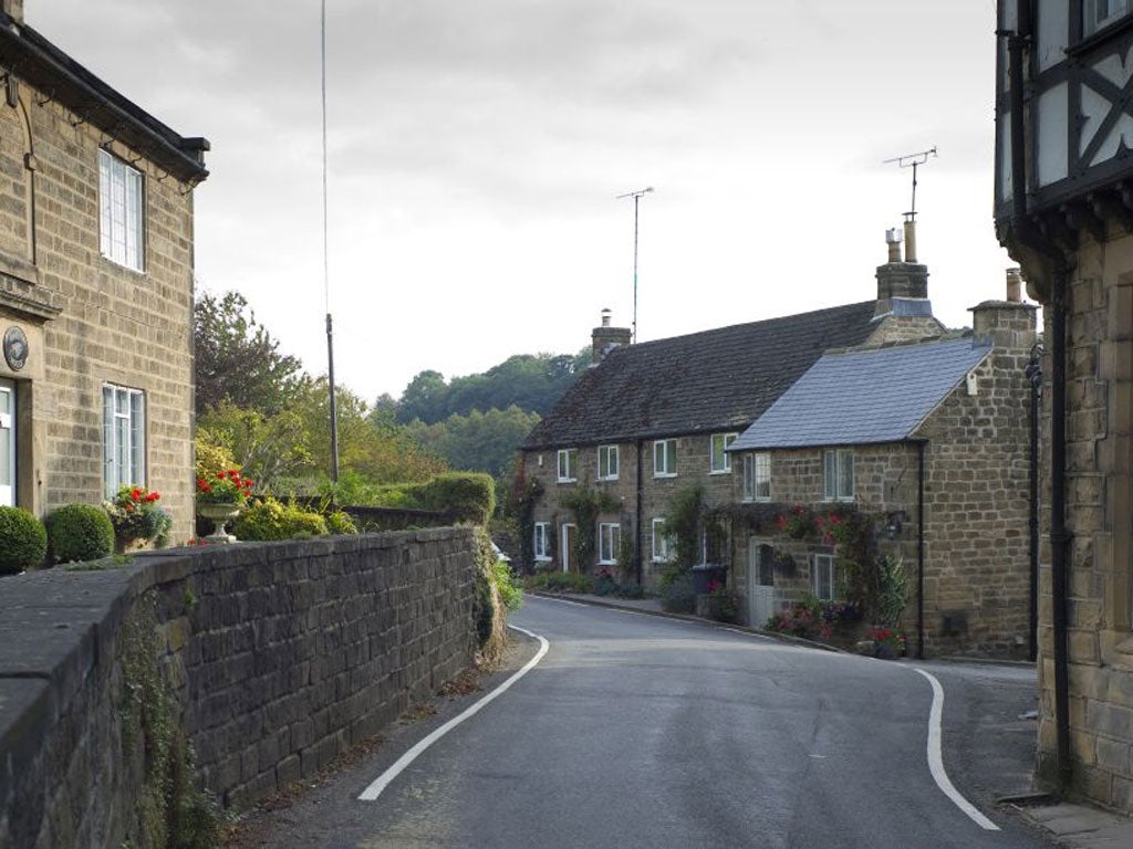
The village of Ashover, in north Derbyshire, is a hop, skip and a jump from the Peak District National Park, and would fit the description of a tourist honeypot – if only it received lots of tourists. Even though the village shares the same handsome architecture as communities in the national park, it can seem a sleepy place, with lace, knick-knack and novelty shops conspicuous by their absence.
The scenery is similar too: little lanes and quiet footpaths undulating over and down soft hills south of Chesterfield, the fields, predominantly given over to grazing livestock, punctuated by stocky farm buildings and hemmed in by dry-stone walls.
The centre of Ashover repays a visit, too, with the broad flanks of All Saints Church inviting inspection of its lead font, a rarity in England, and a legacy of the lead mining industry in these parts. The graveyard is a Victorian delight, crammed with enormous, rectangular, sometimes wafer-thin tombstones, and more substantial horizontal slabs, raised above the ground upon thick, stone table legs.
Then there are the three good pubs, including the Old Poets Corner, which proudly displays several Camra awards. But it's probably best to leave the exploration of the pubs to the end of this walk through the countryside to the south of the village. The hills may not seem so high, but the climb to the skyline requires some puff, and precedes a steep descent into the Amber Valley, followed by a final gentle ascent through the valley back to the village.
Following a sunken, stone-flagged path behind the Old Poets Corner I was struck by the silence; the only hints of birdlife were an incipient chirrup from a small flock of blue tits and the drumbeat of an unseen woodpecker. The path began to rise steadily, passing ghostly, long-neglected gateposts, now mantled in lichens, and past an atmospheric wall of upturned plinths that looked like a row of ethereal, broken teeth. As I entered Ravensnest Wood, the landscape became more eclectic, with a mixture of ancient oak, beech trees and rhododendron.
Briefly the views opened up as I threaded through a series of disused quarries. Ashover thrived for many centuries on lime, lead, coal and gritstone, which nourished local industries including nail-makers and cobblers. Today, aside from the huge scars gouged out of the hillside, the only remaining sign of all this frantic activity is a lonely chimney stack.
Leaving the quarries behind, the path dived into woodland, the contours rising high to the right, but sliding away sharply to the valley floor to the left. A canopy of beech trees covered the path at one point, their glass-smooth branches coiling out horizontally from their trunks. Then the views opened out again and the whole dale was revealed below, capillary-thin hedgerows running through it. The path swooped down from the ridgeline, dropping me below the curiously-named Butterfly Top farm.
The return route was obvious enough, essentially drilling a straight line north-west between Ravensnest Wood and Overton Hall, allowing walkers to fold away their maps and concentrate instead on the scenery. Cattle, from run-of-the-mill Friesians to the more charismatically patterned Belted Galloways, grazed dozily as I sidled along a field's edge. Punctuating the high wood – and hidden when I'd walked through it earlier – was Cocking Tor, protruding out of the trees like a giant, flat saucer and reminiscent of the spectacular and more widespread rock formations found in the Peak District's northern parts.
Then, a couple of light but noteworthy touches: unusual, carefully carved step stiles, and paths that threaded around farms but did not push the walker into irritatingly long diversions from the natural line of sight. Next there was a simple plank laid over a tiny, muddy creek; it took barely four steps to traverse it, yet it had the miniature charm of a child's plaything.
I was on the home straight, walking along Gin Lane past Overton Hall, the former home of Sir Joseph Banks, botanist, naturalist and companion of Captain James Cook. Then, reaching a crossroads where I had earlier headed up into Ravensnest Wood, this time I turned right, back to Ashover, to where it all began. The only taxing decision left was to decide which of the three pubs to settle in: it's fair to say you won't go far wrong with any of them.
Travel Essentials
Distance: Five miles/eight kms.
Time: Three hours.
OS map: Explorer 269, Chesterfield and Alfreton.
Further information
For more information on walking in north-east Derbyshire, go to visitchesterfield.info.
Getting there
Bus 63 runs from Chesterfield to Ashover (0871 200 2233; travelineeastmidlands.co.uk).
Directions
Take bridleway behind The Old Poets Corner pub. At the fork, take the left-hand track, up steps, to the left of the small coppice. Continue up field and straight ahead along the lane and over crossroads.
Follow main path up into Ravensnest Wood and through quarries. Ignore diagonal paths on either side; after 300m, take the waymarked turn sharp left over a dry-stone wall and down to the tree line.
Turn right and follow this main path above the wood. At the first fork, bear right; at the next fork, bear right over wall and follow farm track, and then footpath signs below Butterfly Top Farm to road. Bear right, then left into Coldharbour Lane.
After 300m bear left by footpath sign over field and downhill, through farm, fields and over Carr Brook to road. Go straight ahead on lane, following sign for Milltown and Ashover. After 300m, bear half-left through fields to Greenfield Farm and Raven House, then turn sharp right and half-left towards Gin Lane. Shortly after passing Overton Hall, bear right to retrace your steps to Ashover.
Subscribe to Independent Premium to bookmark this article
Want to bookmark your favourite articles and stories to read or reference later? Start your Independent Premium subscription today.
Join our commenting forum
Join thought-provoking conversations, follow other Independent readers and see their replies