Google Maps fills in the blanks of its North Korea coverage

Sign up to our free weekly IndyTech newsletter delivered straight to your inbox
Sign up to our free IndyTech newsletter
Very few North Koreans enjoy an internet connection and those who do are forbidden access to Google, but the web search giant is giving the rest of the world its first glimpse of the framework of the secretive Communist state.
Click on the image to enlarge
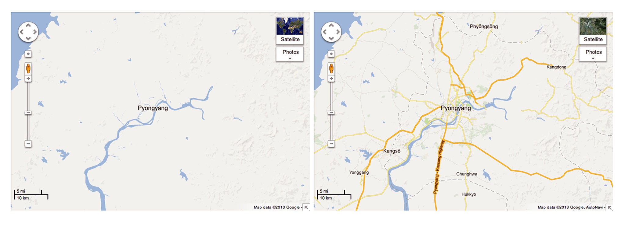
On Monday, Google Maps added a host of new details to its picture of Pyongyang, which was previously little more than a blank space.
Basic infrastructure such as schools, hospitals and subway stops are marked, as are some government buildings. Also visible are the May Day stadium – the world’s largest, with a capacity of 150,000 – and the notoriously ugly Ryugyong Hotel, which at 105 storeys is the nation’s tallest building. Beyond the capital, Google has labelled the Yongbyong nuclear site, and four of the country’s vast gulags, thought to hold around 200,000 people. The largest, Camp 22, contains features such as a lumber yard, a pharmaceutical factory and a guards’ restroom.
The map was constructed with Google’s crowd-sourced Map Maker tool. Members of the public submit data, which is fact-checked by the firm before being added to the map. Map Maker was launched in 2008 and has already been used to provide detail to maps of Afghanistan, Burma and Iraq. The North Korea mapping project has been underway since 2009; it was carried out by volunteers from outside the country, using information that already available online.
Jayanth Mysore, senior product manager at Google Map Maker, wrote in a blog post, “While many people around the globe are fascinated with North Korea, these maps are especially important for the citizens of South Korea who have ancestral connections or still have family living there.” Hwang Min-woo, a 28-year-old volunteer from Seoul, told the Wall Street Journal, “I thought if I could fill in information on North Korea, it might be useful in an emergency or a tragedy if Google can provide a map for aid agencies.”
Earlier this month, Google’s Executive Chairman Eric Schmidt visited Pyongyang as part of a delegation led by the former US ambassador to the UN, Bill Richardson. That was soon after North Korean leader Kim Jong Un declared, in a televised address, that his country’s ailing economy could be improved by embracing science and technology.
Though a Google spokesman said that the timing of the new maps after Schmidt’s visit was mere coincidence, Schmidt is a staunch believer in the power of the internet to undermine oppressive governments. In a Google+ post published after his trip, he wrote, “As the world becomes increasingly connected, the North Korean decision to be virtually isolated is very much going to affect their physical world and their economic growth. It will make it harder for them to catch up economically.”
Subscribe to Independent Premium to bookmark this article
Want to bookmark your favourite articles and stories to read or reference later? Start your Independent Premium subscription today.
Join our commenting forum
Join thought-provoking conversations, follow other Independent readers and see their replies