High drama in Cumbria's drowned valley
Walk Of The Month: Mardale, Cumbria - Mardale was submerged in the 1930s to supply Manchester with water. Mark Rowe explores its haunting beauty

Sign up to Simon Calder’s free travel email for expert advice and money-saving discounts
Get Simon Calder’s Travel email
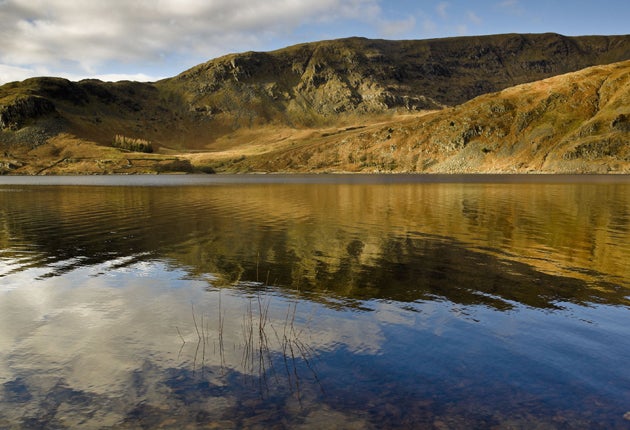
Where the fells of the Lake District tumble eastwards towards the plains and the Pennines, you'll find lonely Haweswater.
Uniquely, an artificial construction, created in the 1930s and, at 240 metres above sea level, it is also the highest of all the region's lakes.
Being at heart a reservoir, Haweswater is unloved by many, but it happens to be the centre of some of the finest – and least trodden – walks in the area. This circular walk from Mardale Head follows the edge of Haweswater before ascending the brutish ridge of Rough Crag, flits across High Street, and traverses a stupendous amphitheatre of fells at the top of the reservoir.
The low-key start – a gentle lakeside amble to the Rigg, a promontory thickly covered with conifers – has offered some startling interest this year, with the wreck of the village of Mardale Green, sunk 70 years ago by the reservoir, re-emerging as water levels dropped.
Mardale had two original lakes, Low and High Water, and antediluvian photographs show a superb landscape of thrilling steep-sided valleys that dwarf fields and coppices. By many accounts, Mardale was the most picturesque Lake District valley, and it remains oddly moving, especially when you learn that the villagers, mainly tenants, were forcibly evicted. The rubble tends to re-emerge every decade or so, and in 1984, the lowest recorded level, people played tennis on the outline of the court attached to the old Dun Bull Hotel.
The views of Haweswater increasingly impress as you climb Rough Crag. Alfred Wainwright called this the connoisseurs' route to High Street: it's straight up, two miles of undeviating ascent and undeniably a hard shift, but one that repays the effort with some glorious scenery.
It's also breathtaking, with the precipitous crags of Riggindale falling away to the north; Striding Edge, along which thousands of us teeter to Helvellyn every year, has nothing on this. The names of the precipices have a brutal, elemental air and include Swine Crag and Eagle Crag – and you have a fighting chance of seeing England's only golden eagle, a solitary male, in this remote quarter.
At some points of this endless ridge, you'll need to use your hands, though this still falls some way short of rock climbing. The two tarns to your left – the south – are Blea Water and Small Water, spectacularly cradled in volcanic craters. Eventually, you reach Caspel Gate – not a gate at all but a grassy depression, and a slightly disheartening one, as after such a vertiginous climb you must lose some height here before the final hike up Long Stile – proof that this walk has real teeth.
Eventually, you emerge on the broad spine of High Street, which runs along the eastern edge of the Lakes. I struggle to think of a better Lakeland panorama – south to Morecambe Bay, north to the Solway Firth, east to the Pennines and Teesdale, and west to pretty much a full house of the popular peaks, from the Langdale Pikes to Sca Fell and Skiddaw.
The unrelenting drama continues on a long and lonely path that reaches out to Mardale Ill Bell, an appropriately named mournful peak marooned by bogs. The path drops steeply to one of the Lake District's most thrilling path junctions at Nan Bield pass, where you can pause at the substantial chair-like rock shelter.
There is just the one more climb left, up Harter Fell. Look north and you may be surprised by how narrow Rough Crag now seems. The views down the length of Haweswater, almost to the dam, are truly graceful. Following a line of fencing, you eventually drop down to the Gatescarth Pass, a steeply zig-zagging descent of the kind that will find out the weaker knees.
Wainwright's knees were certainly up to the task. Throughout his Far Eastern Fells guide, the old curmudgeon fires several pointed barbs in the direction of the decision to flood Mardale. Yet, while decrying the ugly tidemarks at the reservoir's edge, he finally concedes that the job of flooding the village had been done "as unobtrusively as possible" and describes it as still being a "noble" valley.
He's right: far from being a featureless lake, Haweswater is one of unlikely high drama.
Compact Facts
The route
Despite its strenuous nature, the route of this walk is straightforward. From Mardale Head follow the lakeside path to the Rigg. Bear left up the ridge of Rough Crag. Continue to climb for two miles until you reach the top – bear half left, past two cairns, to reach the trig point. Head south with the wall on your right, and after 200 yards bear half-left along a recently restored stone path. This climbs Mardale Ill Bell and then drops to Nan Bield Pass. Keep ahead here to climb Harter Fell and bear left with the fence on your right. Pass two cairns and follow the track round to the right. After 800 yards, bear left steeply downhill and pick up the Gatescarth Pass track to bear left downhill back to Mardale Head.
Time
Four to five hours
Distance
Seven Miles
OS Map
OL5, The English Lakes, North-eastern Area
Further information
Mark Rowe stayed at the Haweswater Hotel (01931 713235; haweswaterhotel.com), which offers room from £45-£175 per night. For more details on walking in the Lake District, visit golakes.co.uk.
Subscribe to Independent Premium to bookmark this article
Want to bookmark your favourite articles and stories to read or reference later? Start your Independent Premium subscription today.
Join our commenting forum
Join thought-provoking conversations, follow other Independent readers and see their replies