Huge ice age river carved the English Channel
Prehistoric Fleuve Manche cut through land bridge to Europe, say scientists
A giant "super river" that carved its way through the chalky white hills connecting southern England to northern France about 450,000 years ago created the English Channel and made Britain into the island that it is today, scientists have discovered.
The prehistoric river flowed through the Strait of Dover with such erosive force that it churned out a channel deep enough to have kept Britain geographically isolated from the rest of mainland Europe since the end of the last ice age about 9,000 years ago.
The scientists said they have found the sediments carried by the river, known as the Fleuve Manche, in the Bay of Biscay where seabed excavations have revealed the sequence of geological events that ultimately led to Britain becoming an island.
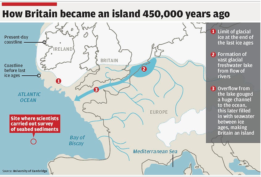
Professor Phil Gibbard of Cambridge University said the findings complete a geological jigsaw puzzle showing how the English Channel was formed when a huge glacial lake in what is now the North Sea broke through a natural dam that had held the lake back for thousands of years.
The huge volumes of water released from the lake created a mega-flood which flowed from the North Sea into the Bay of Biscay, gouging a channel deep enough to form a permanent natural barrier separating Britain from Europe when sea levels rose between ice ages, Professor Gibbard said.
"This is the first time we've looked at what flowed out of the Channel and into the Bay during these crucial periods. It provides the final piece in the puzzle, forming a complete record that reconstructs the dramatic events that cut Britain off from Europe and gave it its island status," he said.
About 500,000 years ago, a land bridge of low hills connected Britain to France between the Weald in south-eastern England and the Artois in northern France. The great rivers of northern Europe, such as the Rhine and Thames, flowed into a freshwater, glacial lake in the southern end of the North Sea which did not freeze but was bordered to the north by glaciers and in the south by the land bridge.
The continual flow of the rivers into this huge lake eventually led to overflowing across the land bridge, sending the water crashing into what was then a wide river valley which eventually became the English Channel. A study of the sediments in the Bay of Biscay suggests that several major floods, the first occurring about 450,000 years ago, carved the river valley into a deep channel.
The study found that the Fleuve Manche existed towards the end of the last three ice ages, and in each case the volume of sediments it carried into the Bay of Biscay increased significantly.
When sea levels rose during the warm period between ice ages, the channel filled with water and Britain became an island. There have been five ice ages in the past 500,000 years, with the last one ending about 9,000 years ago – the last time Britain was connected to mainland Europe and animals and people could cross easily.
Join our commenting forum
Join thought-provoking conversations, follow other Independent readers and see their replies
Comments
Bookmark popover
Removed from bookmarks