
Sign up to the Independent Climate email for the latest advice on saving the planet
Get our free Climate email
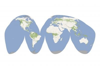
A first-of-a-kind map plotted by scientists using data from NASA satellites shows the Earth's tallest and shortest forests; it is hoped that the map can be used to predict the spread of forest fires and monitor the effects of deforestation and climate change.
On July 20 scientists from American space agency NASA revealed a first-of-a-kind map detailing the world's forests. The map, compiled using data from NASA satellites, is the first of its kind to span the entire globe - previously forestry maps were either local or at best regional.
The map found the world's tallest forests were in Pacific Northwest America and South East Asia while shorter forests were found in broader areas across Canada and Eurasia. The map is being used by scientists to calculate the amount of carbon released by humans every year that gets absorbed by the forests. However according to a statement on NASA's website, one of the more immediate and practical uses of the map is predicting the spread of forest fires.
The map could also provide a means of monitoring the effects of climate change and deforestation on the world's forests. Deforestation and land change use is responsible for 20 percent of the world's emissions, and 48 percent of the world's deforestation occurs in Brazil, according to a 2008 report by the World Resources Institute.
As a result of the damaging effects of deforestation, environmental groups such as Greenpeace have long campaigned for a ban on logging and irresponsible land management.
Consumers can ensure that household goods, such as patio furniture, come from sustainable forests, by verifying that all products have been certified by the Forest Stewardship Council (FSC) - an international non-profit organization providing a certification and labeling system ensuring ecologically responsible forest management. Forests in over 47 countries are now FSC-certified.
The map is available to view online and areas can be zoomed in on to provide a continent-size view of forest coverage.
http://www.nasa.gov/topics/earth/features/forest-height-map.html
Subscribe to Independent Premium to bookmark this article
Want to bookmark your favourite articles and stories to read or reference later? Start your Independent Premium subscription today.
Join our commenting forum
Join thought-provoking conversations, follow other Independent readers and see their replies