Roads submerged amid flood warnings across parts of UK
South Wales has been hit hardest by flooding, with railways blocked, homes left without power and parks, roads and bridges submerged.

For free real time breaking news alerts sent straight to your inbox sign up to our breaking news emails
Sign up to our free breaking news emails
Flood warnings have been issued across parts of the UK as heavy rain continues to fall, submerging roads and parks and putting homes at risk.
The Met Office has issued a yellow warning for rain covering most of the south-west of England and Wales until 5pm on Thursday, with some areas already having had more than 82mm of rainfall.
There are also reports of areas in parts of the West Midlands, such as Shropshire and Herefordshire, becoming submerged.
Some areas are also seeing extreme gusts, with the wet and windy weather likely to carry on throughout the weekend and into next week, with a dip in temperatures bringing with it a risk of sleet and snow.
The Met Office said downpours could see properties flooded and cause power cuts, while regions have already seen delays to public transport as well as road closures.
The Met Office warned the weather may result in hazardous driving conditions and Rhondda Cynon Taf council urged people to only drive if “absolutely necessary”.
The yellow weather warning covers 16 of Wales’s 22 counties, while Natural Resources Wales has issued 19 flood warnings and 35 flood alerts for the country.
Maerdy, an area in the Rhondda Valley, experienced 82.2mm of rainfall between 9pm on Wednesday and midday, Nant yr Ysfa in Pontypridd had 77.2mm, and West Dunkery in the south west had 59.6mm.
In South Wales, the River Taff has burst its banks, flooding a number of parks and walking routes along the Taff trail, including Cardiff’s Bute Park near the city centre, and Taff’s Well Park, which currently lies underwater.
South Wales Fire and Rescue Service said Porth and Pontypridd were the areas worst affected by flooding.
Pontypridd’s popular arts and music venue Clwb y Bont has had to close due to water damage.
Hundreds of properties in Newport have been without power for most of the day, while part of a footpath collapsed into the River Ebbw, leading to its closure by the council.
The River Usk in Powys has also burst, flooding parts of Crickhowell.
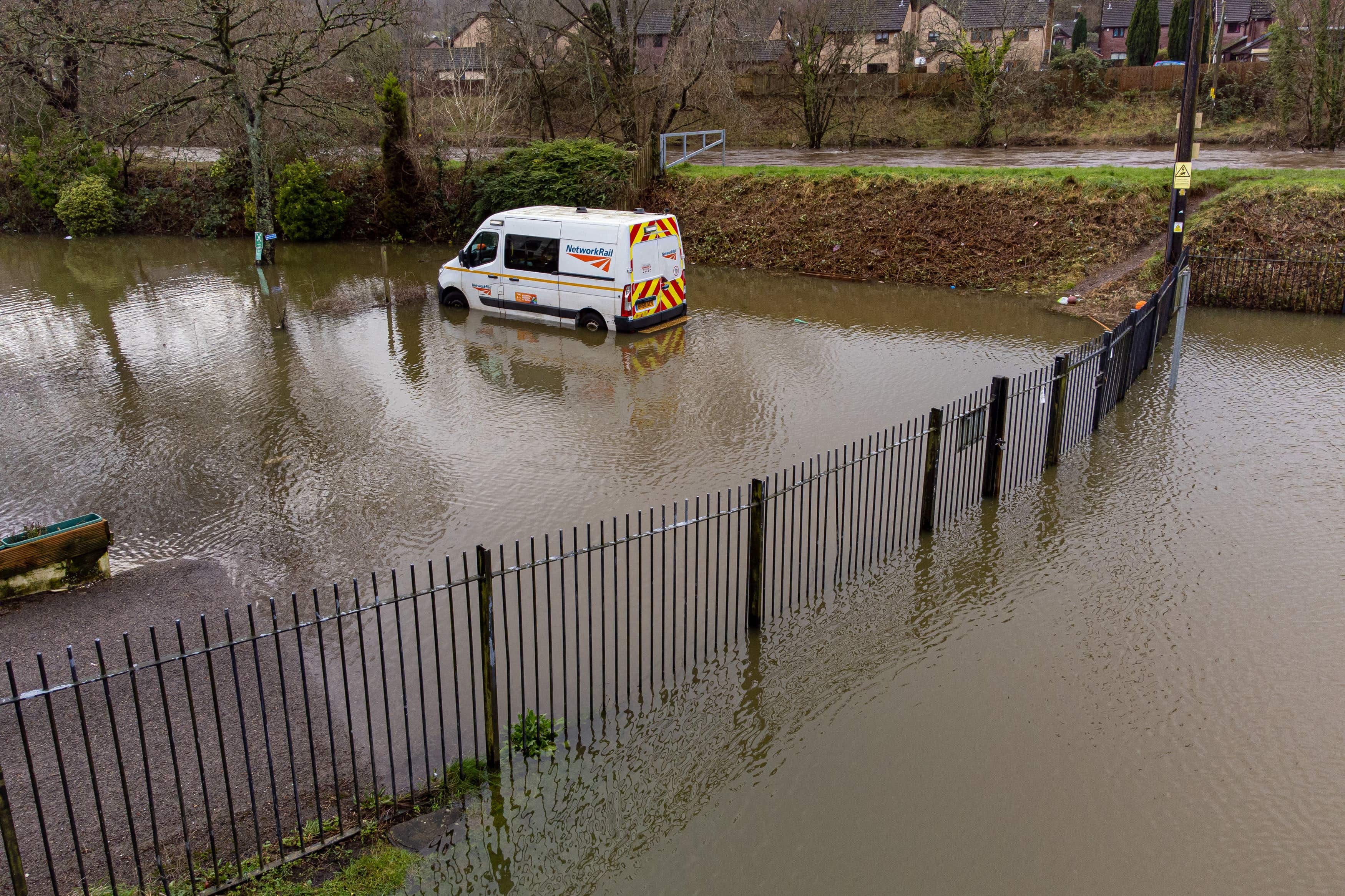
Transport for Wales said four railway lines were blocked due to heavy rain flooding the tracks, including Cardiff Central to Bridgend, Pontypridd to Treherbert, Newtown to Shrewsbury and Abercynon to Aberdare.
Two train lines are blocked between Bristol Parkway and Swindon, and between Bristol Temple Meads and Swindon, with Network Rail saying they will stay closed for the day.
The Environment Agency has issued dozens of flood alerts across the west, with at least 40 flood warnings, meaning flooding is likely.
Pictures have emerged of cars submerged on Old Bristol Road in Keynsham, which is closed.
Avon Fire and Rescue Service said crews had rescued one person from their car shortly before 2am, and at just after 8am they rescued three more people who had become stranded in vehicles.
Meanwhile, residents in Shropshire and the Mid Wales border in Herefordshire were told to take action to protect their homes, due to flooding being expected in Ironbridge and Jackfield, and five other areas including the River Severn at Frankwell, the River Severn at the Showground and The Quarry, the River Teme at Stanford Bridge, the River Vyrnwy at Maesbrook and the River Vyrnwy at Melverley.
There are also wind warnings for north-west England, Northern Ireland and North Wales, with the possibility of gusts of up to 70mph in some areas over the weekend.
A drop in temperatures in the next few days means rain could give way to snow on high ground in northern areas, particularly Scotland, and even sleet on lower ground, a Met Office spokesperson said.
The wet and windy conditions are likely to continue on through Saturday and Sunday and into next week, bringing with them renewed risk of flooding in areas which have already seen heavy rainfall.
Stephen Dixon, spokesperson for the Met Office, said: “The heaviest of the rain has largely moved away eastwards now towards the north of the UK, bringing rain particularly to Scotland later this afternoon.
“However, showers remain possible for large parts of the UK in what will remain a largely unsettled day.
“The low pressure has also triggered a yellow wind warning for Northern Ireland and the far north of Wales and north-west England, and that’s in force from 3pm today until 3am tomorrow morning.
“Within that warning area, you can see gusts of up to 70mph across some exposed coasts, but possibly gusts of around 50mph inland as well.”
He added: “Friday is likely to be unsettled as well, but is mainly a prelude to another band of rain which is going to cause showers throughout most of the UK on Saturday and into Sunday morning.
“On Saturday, the rain is looking likely to be heaviest in the west of Wales and the South West as well, with some areas seeing in excess of 50mm.
“We will be keeping an eye on that because some of that rain will be falling on already saturated ground.
“Temperatures will drop throughout the weekend bringing with it wintry showers, with a possibility of snow on higher ground and sleet on lower ground.”
The Environment Agency’s Mark Garratt advised people to check their flood risk, stay away from swollen rivers and not to drive through floodwater.
Mr Garratt said: “The Environment Agency is monitoring flood levels, operating flood gates and barriers at locations across the country, and ensuring debris screens are clear from blockages to ensure communities are better protected.”
Andy Wall, from Natural Resources Wales, said: “We’ve had a period of significant rainfall over the last 24 hours, which follows on from a prolonged period of very unsettled weather across most of Wales over the last month.
“We had four inches of rain, 100mm, on top of the Brecon Beacons last night and we’ve seen rivers respond to that.
“There’s been widespread travel disruption with flooding of low-lying land and roads.
“We’ve got some isolated reports of property flooding, which is still being investigated.
“Fortunately, we’ve been spared some of the worst which could have happened if the rainfall had been heavier. But overall, it’s a difficult picture across Wales.
“Given the rainfall being forecast by the Met Office into the weekend, we would expect to see rivers full again, and are quite likely to see flooding onto floodplains, farmland, minor roads, and we could see some property flooding, particularly in isolated communities in low-lying areas.”
Mr Wall said in recent years the country has seen “an increased frequency of severe weather” due to climate change, including long periods of drought as well as prolonged periods of wet weather.
Rod Dennis, from RAC Breakdown, said: “Driving through floodwater is never worth the risk – not only are drivers putting themselves and anyone they’re with in great danger if they get stranded, but floodwater can also cause catastrophic damage leading to the vehicle being written off.
“We encourage all drivers to turn around and find another route if they encounter deep standing water.”
Subscribe to Independent Premium to bookmark this article
Want to bookmark your favourite articles and stories to read or reference later? Start your Independent Premium subscription today.