Hurricane Irma: New storm could strike US East Coast by the weekend
Dangerous weather front tracking its way across Atlantic in wake of Harvey, with Caribbean facing most immediate risk

The latest headlines from our reporters across the US sent straight to your inbox each weekday
Your briefing on the latest headlines from across the US
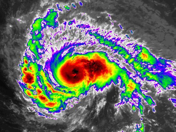
Hurricane Irma has regained Category 3 intensity, and additional strengthening is likely in the coming days as it tracks west across the Atlantic. Environmental conditions could even support Irma becoming a rare Category 5 hurricane at some point, the first since 2016's Matthew. Within the next five days, the Leeward Islands, Puerto Rico, Dominican Republic, Haiti, and the Bahamas are most definitely at risk and should prepare for hurricane conditions (at least a close encounter if not a direct landfall).
Beyond then, forecast confidence drops dramatically. Some models curve Irma back out to sea before reaching the continental US, but a significant percentage of models have Irma striking the US East Coast as early as Saturday or Sunday. Therefore anyone with interests from Florida to New England should monitor forecasts closely.
The centre of Irma is still about 900 miles east of the Leeward Islands, 2,150 miles east-south east of Miami, and 2,150 miles south east of Wilmington, North Carolina. The National Hurricane Center is predicting Irma to pass over or near the Leeward Islands on Wednesday, then to be near the eastern Bahamas by Friday. Beyond that, the spread in model tracks grows, but it usually does at such long lead times. Hurricane watches may be issued later Sunday for the Leeward Islands.
The trend over the past couple of days has been to keep Irma further south for longer, bringing it closer to the US, but still turning toward the north near the coast. With this in mind, locations from south Florida up to New England are most definitely still in play and need to be paying close attention. With the shape of the coastline, a slight difference in timing of that northward turn makes all the difference.
As far as impacts and timing, we can offer some hypothetical scenarios - that is, IF the hurricane were headed for Location A, it would make landfall on Date A. These are not official forecasts, only estimates based on current long-range model guidance. Dangerous tropical storm force winds would typically arrive about a day earlier.
South Florida: Saturday/Sunday (9/10 September)
South Carolina, North Carolina: Sunday/Monday (10/11 September)
Delmarva, Long Island, Cape Cod: Monday/Tuesday (11/12 September)
The aftermath of Hurricane Harvey
Show all 19Looking through the records going back to 1851, 11 previous tropical cyclones passed within 200 miles of Irma's current position as well as its 3-day and 5-day forecast positions (based on Sunday's 5 a.m. EDT advisory). Some infamous ones in that short list are the Great Miami Hurricane of 1926, Hurricane Gloria in 1985 and Hurricane Floyd in 1999.
The Washington Post
Subscribe to Independent Premium to bookmark this article
Want to bookmark your favourite articles and stories to read or reference later? Start your Independent Premium subscription today.
Join our commenting forum
Join thought-provoking conversations, follow other Independent readers and see their replies