For free real time breaking news alerts sent straight to your inbox sign up to our breaking news emails Sign up to our free breaking news emails
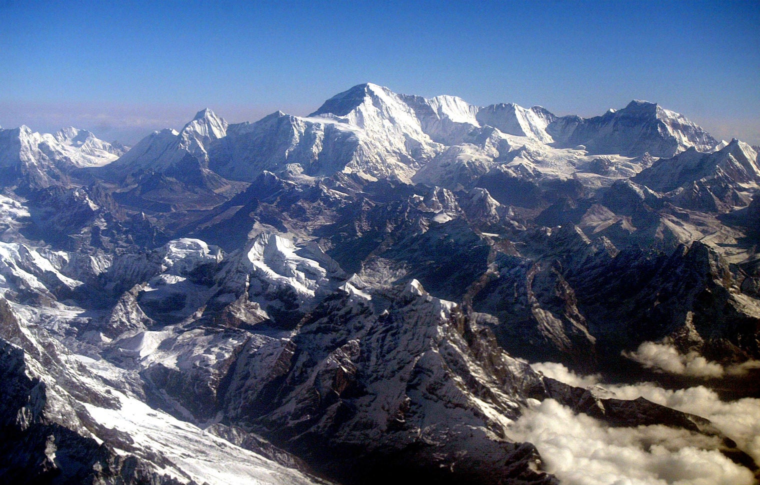
Mount Everest has moved 1.2 inches (3cm) - and changed direction - because of the Nepal earthquake, according to a geological survey by the Chinese government.
It's easy to forget that world's highest peak is moving, both laterally and horizontally. That process has been affected by the 7.8-magnitude earthquake, according to research reported in the state-run China Daily newspaper.
According to research by the Chinese government's National Administration of Surveying, Mapping and Geoinformation, the mountain has moved 3cm to the south-west since the quake, AFP reported.
In the decade to April, Everest, which straddles the China-Nepal border, had moved 40cm north-east at a rate of 4cm per year, as well as rising 3cm.
Satellite data released by the European Space Agency showed last month that Everest shrunk by almost exactly an inch (2.5cm) as a result of the quake.
Eighteen people died in an avalanche caused by the earthquake, on 25 April. More than 8,700 people died in Nepal in that tremor and another one- which did not move the mountain - on 12 May.
Meanwhile, avalanches in Nepal's northern mountains have injured five army rescuers and forced the suspension of a search for bodies in a trekking village that was buried by a landslide during the April earthquake.
The avalanches swept the Langtang Valley, around 35 miles from the capital Kathmandu, on Monday.
Additional reporting by Associated Press
Show all 44 1 /44Powerful earthquake hits Nepal Powerful earthquake hits Nepal Earthquake hits Nepal Victims of the earthquake are cremated at Pashupatinah Temple in Kathmandu
Getty Images
Powerful earthquake hits Nepal Earthquake hits Nepal An elderly woman prays at a temple in Kathmandu damaged by the earthquake
AP
Powerful earthquake hits Nepal Earthquake hits Nepal Nepalese police push back residents who began protesting after waiting for hours in line to board buses back to towns and villages
Getty
Powerful earthquake hits Nepal Earthquake hits Nepal A Nepalese policeman guards a collapsed building in Kathmandu. The number of people killed in the earthquake has passed 5,000 according to official figures
EPA
Powerful earthquake hits Nepal Earthquake hits Nepal A woman stands in silence in front of the historic Bal Krishna Thapa Chhetry temple in Kathmandu, which was been damaged by the earthquake
EPA
Powerful earthquake hits Nepal Earthquake hits Nepal Rescuers from Japan in the centre of Kathmandu; they are facing a race against time to find survivors
Getty
Powerful earthquake hits Nepal Earthquake hits Nepal Pallets of Australian aid (blankets, tarpaulins, hygiene kits and water purification tablets) are loaded onto a No. 36 Squadron C-17A Globemaster aircraft in preparation for delivery to Nepal
Getty Images
Powerful earthquake hits Nepal Earthquake hits Nepal Rishi Khanal is rescued after being trapped in a collapsed building in Nepal’s capital following Saturday’s earthquake
Reuters
Powerful earthquake hits Nepal Earthquake hits Nepal Villagers shelter from rain in the Gorkha district, north-west of Kathmandu; 10 days of rain are forecast, with tens of thousands of people sleeping outdoors
AFP/Getty
Powerful earthquake hits Nepal Earthquake hits Nepal A prayer bell is seen on top of the rubble of a damaged temple after an earthquake in Kathmandu, Nepal
Reuters
Powerful earthquake hits Nepal Earthquake hits Nepal People search through the rubble at the earthquake damaged Durbar Square in Kathmandu. Hundreds of thousands of Nepalis spent another night in the open after a massive quake which killed more than 4,000
AFP/Getty
Powerful earthquake hits Nepal Earthquake hits Nepal A priest prepares a fire for the cremation of an earthquake victim at Pashupati cremation center in Kathmandu, Nepal. The official death toll from the magnitude 7.8 earthquake has risen to 5,057 people
EPA
Powerful earthquake hits Nepal Earthquake hits Nepal A Nepalese villager injured in an earthquake holds her son as they sit inside an Indian Army helicopter after being evacuated from Lapu in Gorkha
AFP/Getty
Powerful earthquake hits Nepal Earthquake hits Nepal A satellite image showing a part of the city's historic center, left, before the 25 April 2015 earthquake and the after effects, right
EPA
Powerful earthquake hits Nepal Earthquake hits Nepal An injured woman and her daughter receive medical treatment after arriving at Dhading hospital, in the aftermath of the earthquake, in Dhading Besi
Powerful earthquake hits Nepal Earthquake hits Nepal An elderly woman mourns in front of her destroyed home in the Kumalpur village, on the outskirts of capital Kathmandu
Powerful earthquake hits Nepal Earthquake hits Nepal Earthquake victims collect belongings and salvage food items from a destroyed building after a major earthquake, Kumalpur village, on the outskirts of capital Kathmandu
Powerful earthquake hits Nepal Earthquake hits Nepal A Nepalese girl injured in the earthquake holds the hand of her mother inside an Indian air force helicopter as they are evacuated from Trishuli Bazar to Kathmandu airport in Nepal
Powerful earthquake hits Nepal Earthquake hits Nepal Nepalese victims of the earthquake lie inside an Indian air force helicopter as they are evacuated from Trishuli Bazar to Kathmandu airport in Nepal
Powerful earthquake hits Nepal Earthquake hits Nepal An injured boy sleeps on the ground outside the overcrowded Dhading hospital in Dhading Besi
Powerful earthquake hits Nepal Earthquake hits Nepal Members of a rescue team from China huddle while planning their operation at the site of earthquake in Kathmandu
Powerful earthquake hits Nepal Earthquake hits Nepal Local people gather at the top of large mound where once stood a temple to view the scene of devastation in Kathmandu
Powerful earthquake hits Nepal Earthquake hits Nepal People pray before cremating the body of a victim of the earthquake, along a river in Kathmandu, Nepal
Powerful earthquake hits Nepal Earthquake hits Nepal Nepalese soldiers carry a wounded man on a makeshift stretcher to a waiting Indian air force helicopter as they evacuate victims of the earthquake from Trishuli Bazar to Kathmandu airport in Nepal
Powerful earthquake hits Nepal Earthquake hits Nepal An Indian Air Force person carries a Nepalese child, wounded in the earthquake, to a waiting ambulance after the child and mother were evacuated from a remote area at the airport in Kathmandu
Powerful earthquake hits Nepal Earthquake hits Nepal An Indian Air Force person walks carrying a Nepalese child, wounded in the earthquake, to a waiting ambulance as the mother follows after they were evacuated from a remote area at the airport in Kathmandu
Powerful earthquake hits Nepal Earthquake hits Nepal Indian resident Santosh (2L) is met by relatives after being evacuated following an earthquake in Nepal at the railway station in Amritsar
Powerful earthquake hits Nepal Earthquake hits Nepal A helicopter prepares to rescue people from camp 1 and 2 at Everest Base Camp, Nepal
Powerful earthquake hits Nepal Earthquake hits Nepal People carry a woman from the rubble of a destroyed building after an earthquake hit Nepal, in Kathmandu, Nepal
EPA
Powerful earthquake hits Nepal Earthquake hits Nepal People try to free a living man from the rubble of a destroyed building after an earthquake hit Nepal
EPA
Powerful earthquake hits Nepal Earthquake hits Nepal A man struggles to free himself from under the rubble of a destroyed building after an earthquake hit Nepal, in Kathmandu, Nepal
EPA
Powerful earthquake hits Nepal Earthquake hits Nepal People free a man from the rubble of a destroyed building after an earthquake hit Nepal, in Kathmandu, Nepal
EPA
Powerful earthquake hits Nepal Earthquake hits Nepal Dust can be seen over the city during an earthquake in Kathmandu, Nepal, 25 April 2015.
EPA
Powerful earthquake hits Nepal Earthquake hits Nepal A building stands damaged after an earthquake in Kathmandu, Nepal, Saturday, April 25, 2015
AP
Powerful earthquake hits Nepal Earthquake hits Nepal Nepalese people walk past a collapsed building in Kathmandu on April 25, 2015.
AFP/Getty Images
Powerful earthquake hits Nepal Earthquake hits Nepal An injured man is assisted after an earthquake caused serious damage in Kathmandu, Nepal, 25 April 2015.
EPA
Powerful earthquake hits Nepal Earthquake hits Nepal An injured child lies on the ground outside the Medicare Hospital in Kathmandu, Nepal, Saturday, April 25
AP
Powerful earthquake hits Nepal Earthquake hits Nepal Nepalese health workers carry injured people into an open area following an 7.9 earthquake, at Lalitpur on the outskirts of Kathmandu on April 25, 2015.
AFP/Getty Images
Powerful earthquake hits Nepal Earthquake hits Nepal Indian bystanders look at a collapsed house following an earthquake, in Siliguri on April 25, 2015
AFP/Getty Images
Powerful earthquake hits Nepal Earthquake hits Nepal Volunteers help with rescue work at the site of a building that collapsed after an earthquake in Kathmandu, Nepal, Saturday, April 25
AP
Powerful earthquake hits Nepal Earthquake hits Nepal Nepalese rescue members and onlookers gather at the collapsed Darahara Tower in Kathmandu on April 25, 2015.
AFP/Getty Images
Powerful earthquake hits Nepal Earthquake hits Nepal People search for survivors stuck under the rubble of a destroyed building, after an earthquake caused serious damage in Kathmandu, Nepal, 25 April 2015.
EPA
Powerful earthquake hits Nepal Earthquake hits Nepal Nepalese rescue members move the body of a victim from the collapsed Darahara Tower in Kathmandu
GETTY
Powerful earthquake hits Nepal Earthquake hits Nepal Health workers take care of injured people outside the Manmohan Memorial Community Hospital after an earthquake caused serious damage in Kathmandu, Nepal
EPA

Join our commenting forum
Join thought-provoking conversations, follow other Independent readers and see their replies