The Independent's journalism is supported by our readers. When you purchase through links on our site, we may earn commission.
Have a Swale of a time walking in the Yorkshire's Dales
Walk of the Month: Walk one of Yorkshire's most dynamic waterways, says Mark Rowe

Sign up to Simon Calder’s free travel email for expert advice and money-saving discounts
Get Simon Calder’s Travel email
The Yorkshire Dales can be rugged with hills that clamber steeply out of its secluded valleys. But it is the rivers that really grind out these dales and this walk tracks one of the most dynamic waterways in the region, the River Swale. Beginning in Richmond, it takes in a superb valley walk before returning to town along a path high above the River Swale as it goes eastwards from its Pennine watershed to the River Ouse and the North Sea.
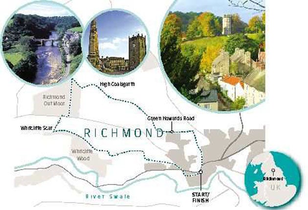
This walk was suggested by John Deighton, who is involved in the Richmond Walking and Book Festival (richmondbookfestival.com). Begin in Richmond's cobbled Market Place, where you need to find Friars Wynd, a narrow lane that passes through a postern gate, a remaining part of the town wall, and emerges by the Theatre Royal.
Cross the road and go up the steps to the tourist office and enter Friary Garden. Pass through the gardens with the remains of the 13th-century Franciscan friary on your left, and leave via the far right-hand gate by the well. Continue across the roundabout and Quakers Lane to climb the steps to a snicket (a narrow pedestrian way). Continue uphill to emerge at Green Howards Road. Below you can see Richmond Castle. Turn left for around 20 yards, cross the road and go through a narrow stile in the drystone wall.
Head half-left across the field, picking up the waymarkers as you cross two fields, before arriving at the old racecourse, now a public common. To the east, the view extends to the North Yorkshire Moors. Turn left and head west for three-quarters of a mile towards a large ruined grandstand. From the grandstand head north, following the clear track through a gap in the wall and walk through a small plantation and through a gate. Bear left and, with the wall on the left, follow the waymarked footpath up and then down into the Coalsgarth Valley. This is an enchanting stretch, as the valley slowly comes into view, dotted with ruined cottages, drystone walls and lime kilns and flanked with woodland. Follow the waymarks along the bottom of the valley – passing through two gates – until you reach its head, where you cross a stile on to a bridleway. Turn right to cross the stream and another stile. Climb the hill to reach a gate. Bear left in front of the gate, following the track as it arcs back through coniferous woodland.
Follow the path through the forest. After three-quarters of a mile you reach a road, where you turn right, then cross a ladder stile on the left a few yards along the road. Follow the beaten track over the moor to a fence and gate where Swaledale is laid out in front of you. This spot is known as Willance's Leap, after Robert Willance, a draper who tumbled off his horse here in mist in 1606. The horse was killed and Willance tucked his broken leg inside the horse's body to keep it warm overnight. The monuments here mark the final two strides of the horse. The view is striking, with Hag Wood covering the far side of the dale dominated by the moors.
Return through the gate and turn right, heading east along Whitcliffe Scar. Keeping the wall and escarpment on your right, follow the waymarked path. After the double ladder stile, head for the far left-hand corner of the field to the two-step double stile. Follow the main track, with more sweeping views of Swaledale, as it weaves between hawthorn bushes and gorse, with Richmond spread out in the valley.
Just after the gorse bushes, bear right downhill to a stile at High Leases farm. Over the stile, turn left and follow the road past a small holiday cottage on your right, along with a Richmond boundary stone and a dedication to Alfred Wainwright, whose coast-to-coast route passes through here. Just beyond the dip, pass through the kissing gate into Westfield. Head south for about 150 yards and then turn left (east) to follow the contour along Westfield, through a coppice and emerge through a kissing gate on to the Westfield road. Walk down the road and across Reeth Road to enter the cobbled street of Newbiggin, then re-enter Market Place via Finkle Street.
Walk of the Month: Facts
Distance: seven miles
Time: between three and three-and-a-half hours
OS Map: OS Explorer 304, Darlington and Richmond.
Mark Rowe stayed at Natural Retreats ( naturalretreats.com ) near Richmond, which offers two-night stays in a chalet sleeping up to six people from £325.
How to get there
The nearest train station to Richmond is at Darlington, which is served by Cross Country trains ( crosscountrytrains.co.uk). Buses run frequently between Darlington rail station and Richmond.
Subscribe to Independent Premium to bookmark this article
Want to bookmark your favourite articles and stories to read or reference later? Start your Independent Premium subscription today.
Join our commenting forum
Join thought-provoking conversations, follow other Independent readers and see their replies