Postcard from the edges: Stick to the coasts of the Canaries and you'll find spectacular scenery, deserted beaches and a touch of the Caribbean

Sign up to Simon Calder’s free travel email for expert advice and money-saving discounts
Get Simon Calder’s Travel email
Charles Darwin was impressed: shortly after the great naturalist began his five-year voyage on which his theories evolved, he sailed past Tenerife in January 1832. "The first of many days never to be forgotten," he declared, even though he was banned from landing because of fears that HMS Beagle might bring cholera.
The view that Darwin enjoyed in the early 19th century is remarkably similar to that of the early 21st century. Tenerife is dominated by Teide, Spain's highest mountain, whose towering silhouette fills the view from the ocean. The snow and sunburned lava close to the summit of this volcano merges into a belt of forest that encircles most of the island, bestowing a certain Alpine freshness to upper altitudes. Closer to sea level, though, you need to focus in on the detail: the raw edges of rock that are mostly tickled, but occasionally tormented, by the ocean. In the aeons since the Canaries emerged from the sea, the Atlantic has sculpted shorelines that range from gentle beaches to soaring cliffs.
Generations of travellers have subsequently shared the view of the coast that Darwin witnessed – from emigrants in search of a new life in the New World, whose ships happened to pause for replenishment in the Canaries, to inquisitive pre-jet age adventurers taking a slow boat to these Atlantic fragments of Spain.
My appreciation of the shores of the Canaries was a little more prosaic; I bought a £399 hop around the islands in the first wave of budget cruises that was launched in the mid-1990s. Cheap, cheerful and enlightening: the arrival in Arrecife in Lanzarote was one of those great travel moments when the muddle of houses in primary colours gradually took shape as the Sundream approached the shore and the morning mist melted away. And on every journey to the Canaries since, I have sought to combine my terrestrial explorations with marine meandering, using the excellent network of ferries that link the islands (see page VII for more details).
The southern shore of Tenerife is a place of constant fascination for me. Certainly, the rocky coastline has been much built-upon. Yet even around Playa de las Americas and the other resorts that cluster together, you can find patches of shore where shoulders of rock shrug off man's attempts to colonise the island. And another conurbation, Los Cristianos, provides options for escaping the crowds and enjoying the coast from the best perspective: the sea. Frequent fast ferries shuttle between Los Cristianos and San Sebastiá*de la Gomera. In less than an hour, you are transported between the intensively developed shoreline of southern Tenerife and the diminutive main town of La Gomera – virgin territory for many visitors to the Canaries, with virgin forest draped over the hillsides. Even if you delve no deeper than the nearest bar in San Sebastian before hopping on the next sailing back, you will develop an appetite for the archipelago's shores. And, should dolphins opt to race the boat back to Tenerife, you get an aquatic wildlife experience added on as these mischievous mammals jive in the bow wave.
Way over east, take the opportunity to contrast the shores of the unidentical twin islands of Lanzarote and Fuerteventura. The main resort in the north of the latter, Corralejo, has a certain harsh beauty – and a handy jumbo-sized catamaran waiting to grant you a seaborne perspective. As Fuerteventura retreated, I could properly appreciate the meaning of the word "windswept" – and why, with rocky shores washed by sparkling seas, the island is such a hit with watersports enthusiasts. Ahead, Playa Blanca provided a welcome to an island that still has a secret shoreline: Playa Papagayo, almost deserted when I was there, is protected by a barricade of rock and is hard to reach by road.
The best approach, as the astute yachtsman who drifted into the bay demonstrated, is by sea. Nevertheless, for the land-based shore explorer, Lanzarote's resorts are compact and artfully arranged around the coast, especially the exquisite Puerto del Carmen – where cafés and restaurants perch on the very edge of the shore, while palm trees trespass on to the fingers of rock that extend towards the ghostly shape of Fuerteventura. You can see where César Manrique, Lanzarote's late, great artist in residence, found much inspiration.
At the top end of Lanzarote, a very different vessel and vista awaits. The island ends with something of an exclamation mark, a thrust of rock that rises dramatically above the ocean. At the top is the most agreeable Mirador del Rio, a restaurant with a sweep of glass for you to enjoy the view. You should be able to spot the small boat that shuttles across the often-lively El Rio strait to La Graciosa, the largest of the Archipelago Chinijo: the sprinkling of islands that could be labelled Canaries Junior. From Orzola, the port on Lanzarote, the craft must round the needle-like Punta Fariones before docking at Caleta del Sebo, the "capital" of Graciosa. Prominent among its enterprises is the bike-hire shop, which is the best way to sample the sandy extremities of an island where nature is still very much in control.
How different it feels to Las Palmas, the largest city in the archipelago and the capital of Gran Canaria. But Las Palmas possesses that most agreeable of concepts, a long stretch of city beach. The Playa de las Canteras boasts a well-kept promenade, from which you can admire the poseurs and kite-surfers catching the sun, the wind and the waves. Also enjoy the architecture and ice-cream artistes, and treat yourself for lunch at the dramatic waterside La Marinera.
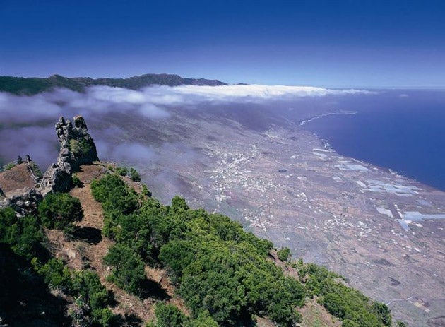
Las Palmas (the city) and La Palma (the island) may be linguistically similar, but they are very different concepts. La Isla de La Palma is the furthest from a continental land mass, almost 300 miles from the coast of Africa. The shape on the map always reminds me of an uncut diamond, but the three-dimensional reality as you view la isla verde from the one proper stretch of coast road – down the east side of the island – is even more dazzling. The northern part of the island, with dense vegetation and banana cultivation, is the closest you get to a Caribbean seaside in the Canaries. And I sensed similarities with the coast of la Octava Isla, as Venezuela is known in the Canaries because of its ethnic links with the archipelago: the exposed hills in the south of La Palma resonate with some of the harsher shores of that South American country.
Santa Cruz de la Palma is perhaps the prettiest and most immediately accessible of the Canarian ports, a town whose colour scheme is a pleasing mix of cream and tobacco. And even more pleasingly, it is the place where you can take a cruise from Santa Cruz to Santa Cruz, the latter being the capital of Tenerife. Mine was aboard one of the mighty Trasmediterranea fleet, big roll-on, roll-off ferries that are so well equipped that I paid a little extra for a cabin on the 120-mile voyage.
This is a particularly appealing crossing, since it hugs the northern shore of Tenerife: a terrace of terrain from tiny coves to rugged mountainsides, before the blinking Faro de Anaga signals the sharp turn to starboard as it runs down beside the popular Playa de las Teresitas (a quick bus ride from the capital, incidentally) and into the busy port of Santa Cruz. Somewhere behind the coastal fringe lies the ancient city of La Laguna, where the first Spanish colonists located their capital to be safely away from the dangerous coast in the years of post-Columbian expansionism.
One distant shore has so far eluded me: the coast of El Hierro, the island that Ptolemy decreed nearly two millennia ago as the end of the world. Indeed, it remained the prime meridian until the late 19th century when the line was moved to the more humdrum surroundings of London SE10, better known as Greenwich. Meantime, hardly anything has happened to El Hierro apart from its being elevated to the status of "biosphere reserve" by Unesco (in the company of Lanzarote, Fuerteventura, La Palma and Gran Canaria). I hope to get there in the next year or two. When I do, I shall make the journey from Puerto de la Estaca (the port close to the capital, Valverde) across to the Faro de Orchilla – the lighthouse that marks the far end of the Canaries. Next stop South America; now, what time's that ship?
Subscribe to Independent Premium to bookmark this article
Want to bookmark your favourite articles and stories to read or reference later? Start your Independent Premium subscription today.
Join our commenting forum
Join thought-provoking conversations, follow other Independent readers and see their replies