This is no bog-standard mountain hike
Walk Of The Month: The Sperrins - It's a rugged place of ancient stone circles and battlefields. And there's gold in them there hills. Mark Rowe steps out
Low clouds rushed past overhead, dipping to squeeze through the narrow valleys of the Sperrins, Northern Ireland's biggest mountain range.
The autumnal gloom merely enhanced the atmospheric setting and lush hillsides, whose flanks are home to ancient cairns and fairy trees – perhaps a solitary hawthorn – that are never to be felled, nor their fallen branches gathered, for reasons of genuinely felt superstition.
The Sperrins, roughly 60 miles west of Belfast, and topped and tailed by counties Derry and Omagh, cover 100 square kilometres (39 square miles). And, despite being an Area of Outstanding Natural Beauty, almost no one knows about them. They are a forgotten, lonely corner of the UK.
My walk started in the car park at Drumnaspar, two miles east of Plumbridge, one of only a handful of large villages and small towns on the map in this part of the world. It is also the name of the ridge that rises to the east. The name translates as "ridge of the battle axe" and these steep-sided, narrowing valleys were the site of one of the first major victories of the Irish over the Vikings in 856.
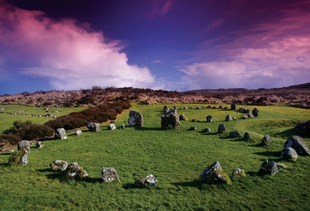
You won't see a Viking, or almost anyone else, on foot here these days. But I had a companion for my walk through Glenelly, or Fortress Glen – Brendan Gormley, a phenomenally knowledgeable local guide. Up on the hills to the north were the remains of ringed forts, or enclosed farmsteads, known as raths; across the Sperrins there are 90 stone circles; on our left the Glenelly River rushed along on its westwards journey to Lough Foyle.
"The Sperrins are very sparsely populated, so you have the real chance to be somewhere on your own," said Brendan, as, almost on cue, he reached down to point out a four-leaf clover. "You're likely to have the hills completely to yourself. There are huge tracks of hill. You can see heaths and bogs, and there's nothing else for a long, long way."
The Sperrins get their name from the Irish Na Speiríní, meaning "spurs of rock", though they are much more rounded and less angular than this implies. They date back 600 million years and comprise low-grade slate, and quartz, which is the source of the local tradition of panning for gold. (Don't rush – if you panned for a year or two you might just get enough for a filling.) The Sperrin range, a succession of whaleback peaks, dominates the skyline, reaching their highest on Sawel (2,224ft). The Ice Age sheered off the rough edges, giving them the appearance of inverted pudding bowls.
After a mile, we came to Toberanna, a sheltered shrine with a Virgin Mary, though such wells and shrines have their roots firmly in the pagan past. "People in Glenelly were supposed to be particularly barbarous and pagan," said Brendan, although local evidence suggests St Patrick had passed this spot. We reached the pass known as the Barnes Gap. (Thanks to linguistic confusions, Barnes means "gap" in Gaelic, so pedants will be pleased to note the name means "Gap Gap".) Heading uphill, you're sure to pass the yappy dogs of the local farm – their barking has become a rite of passage for hikers in the Sperrins.
This was the heart of the Sperrins: lumpy hills closed in to the west, with exposed rocky walls the lonely home of peregrine falcons. Off to the left, we took a short detour along a track to a Mass rock, where Irish worshippers, forbidden to practise in churches, held services in the open air. The views opened up to the south and west, and we followed a delightful path along the contours of the mountain, passing the mournful remains of abandoned houses. The verges were home to pixie caps, small mushrooms that yield a black ink when squeezed.
Our route climbed up to Craignamaddy Ridge. The panorama on a clear day is reward for the plodding, boggy climb – the Mourne to the east, the conical shape of Muckish to the west in the Donegal highlands, and the Sperrins bouncing along to the north. The top of the ridge is also a watershed, and sheep have disappeared for good in some of the deeper cracks in the bogs. No walkers have yet suffered the same fate and since the peat here dates back 3,600 years, it's high time more of us explored the superb scenery.
Compact Facts
How to get there
Translink Ulster Bus (028-90 666630; translink.co.uk) runs between Omagh and Plumbridge and stops at the car park. Mark Rowe stayed at Ardtara Guesthouse, Upperlands (028-796 44490; ardtara.com), which offers B&B from £99 per room per night.
Further information
Sperrinstourism.com, discovernorthernireland.com, discoverireland.com/gb/. About Ulster (028-81 647112; aboutulster.eu), run by Brendan Gormley and Martin Bradley, offers highly recommended bespoke guided walks around Northern Ireland.
Directions
Distance: Seven miles
Time: Four-five hours
OS Map: Sperrins 1/25,000, Ordnance Survey of Northern Ireland.
Route: From Drumnaspar car park, turn left along the road and first left, signposted Barnes Gap, over the bridge. Follow the road left, with the river on your left. Continue for 2.5 miles to Barnes Gap car park. Turn right, go uphill along the second of two lanes, marked for the Craignamaddy circuit. Turn right at the top. After a mile, bear half-right, follow marker for the Craignamaddy circuit. Ignore a waymarked stile over a fence and instead continue ahead until you reach a farm with red gates. Walk across the front of the farmhouse and follow the track uphill with the fence on your right. After 200 yards, turn left uphill, keeping ahead to the ridge and a fence. Turn right, crossing a low fence, and cross the stile. Follow the posts across the bogs to a stile and the rough track downhill. The path becomes a road. At the first crossroads by the "Give Way" sign, turn right downhill; at the next meeting of lanes, continue straight ahead; at the T-junction, turn left to return to the car park.
Join our commenting forum
Join thought-provoking conversations, follow other Independent readers and see their replies
Comments
Bookmark popover
Removed from bookmarks