The Dymaxion map: A more geographically accurate world map that also promotes global cohesion
'Traditional world maps reinforce the elements that separate humanity'
Think ‘world map’ and your mind probably jumps to the elliptical Winkel tripel projection, often seen in textbooks and incorporated in world news logos.
It’s pretty ubiquitous, but is just one of dozens of world maps trying to solve the unsolvable problem of representing a 3D sphere on a 2D plane.
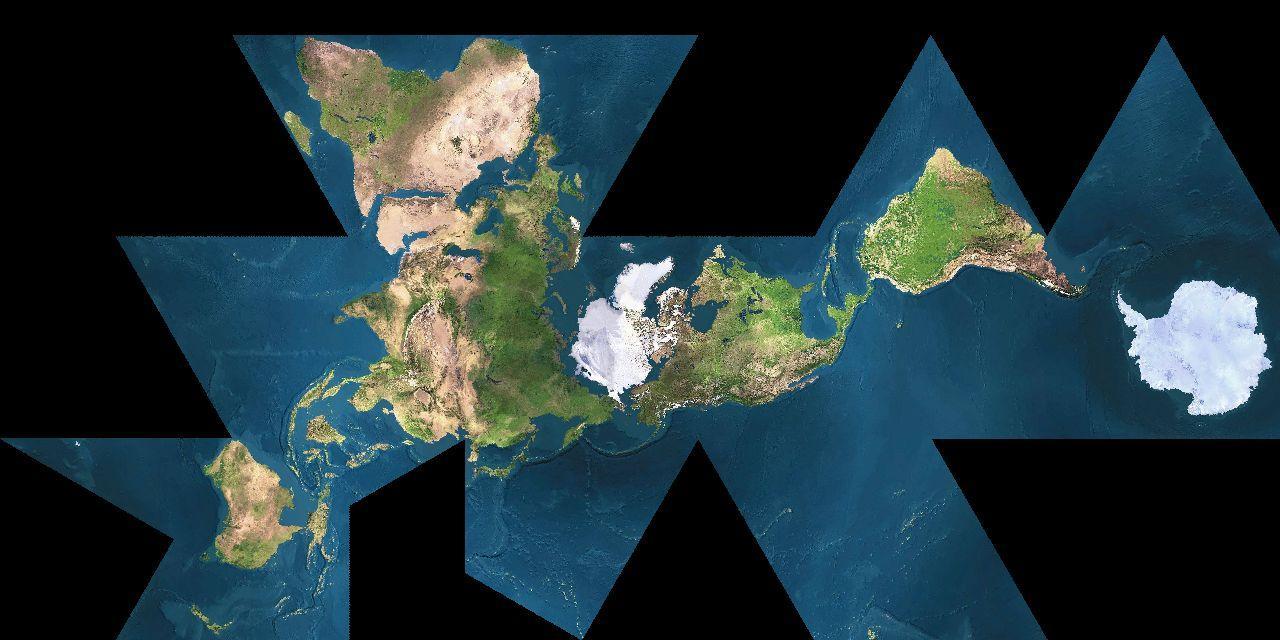
The Dymaxion map, invented by systems theorist and designer Buckminster Fuller in 1943, is one such attempt to display the Earth while preserving its dimensions.
Unlike other projections, it can be folded into an icosahedron with almost contiguous land masses:
There are several advantages to it.
The Dymaxion map “is the only flat map of the entire surface of the Earth which reveals our planet as one island in one ocean, without any visually obvious distortion of the relative shapes and sizes of the land areas, and without splitting any continents,” the Buckminster Fuller Institute explains.
Its unorthodox shape resists the skew compromises of other projections.
“As the earth is a spherical body, so the only true cartographic representation of its surface must be spherical. All flat surface maps are compromises with truth,” Fuller wrote in his 1946 patent.
“For example, Mercators projection is true to scale only along the equator, and azimuthal projection is limited to convergence of the meridians at one pole at a time. Other known systems of projection can be made to give uniform scale along parallels, or to give equal areas albeit with exaggerated shape distortions.”
According to the Institute, the map’s importance transcends geography however, its shape forcing us to conceive the world in a different way, a way not delineated as East and West.
“Traditional world maps reinforce the elements that separate humanity and fail to highlight the patterns and relationships emerging from the ever evolving and accelerating process of globalization,” the BFI notes.
“Instead of serving as "a precise means for seeing the world from the dynamic, cosmic and comprehensive viewpoint," the maps we use still cause humanity to "appear inherently disassociated, remote, self-interestedly preoccupied with the political concept of its got to be you or me; there is not enough for both."
Most schools around the world still use the Mercator projection, though a school in Boston this week switched to the Peters projection, which shows the developed world in a smaller, truer way.
Join our commenting forum
Join thought-provoking conversations, follow other Independent readers and see their replies
Comments
Bookmark popover
Removed from bookmarks