‘Concurrent disasters’: How California could see more severe mudslides as a result of wildfires
Last week a scenic stretch of the iconic Highway 1 collapsed into the ocean near Big Sur following a storm. Wildfires and debris flows are called ‘concurrent disasters’, and latter can be as dangerous as original blazes
The unprecedented and devastating 2020 California wildfires have left some regions vulnerable to mudslides and debris flows.
Last week, a scenic stretch of the iconic Highway 1 coastal route from LA to San Francisco collapsed into the ocean following a storm. California Highway Patrol images revealed a chasm in the road about 15 miles south of Big Sur.
The event, known as a slip out, saw mud and debris cascade down the hillside, overwhelming drainage infrastructure. It’s unclear when repairs will begin, and currently the highway remains closed.
The debris flow took place in the burn scar of the Dolan wildfire last August, according to local news blog Big Sur Kate, which destroyed 100,000 acres and 14 buildings.
Dr Jason Kean, a hydrologist with the US Geological Survey (USGS), and his team research post-fire debris flows. He told The Independent that wildfires substantially increase the risk of landslides.


"When intense rain falls on steep slopes after moderate to high-burn severity, that can trigger rapid runoff and erosion. A debris flow – a mixture of water, rocks, boulders, and mud – can move incredibly fast," he said.
The USGS team is assessing impacts from last week’s storm in several burn areas in California and are yet to visit the Highway 1 failure.
Dr Kean noted that the stretch of highway along the Big Sur coast has long been susceptible to landslides, and they're not always related to fires. However a USGS hazard assessment following the Dolan Fire found there was an 80-100 per cent likelihood of a debris flow following concentrated rainfall.
“Our modeling suggested [the area] was very susceptible to debris flows after the fire and that played out,” Dr Kean said. "The amount of rain that can cause problems after a fire is relatively low. A garden-variety storm can cause a problem. The more intense the rainfall is the bigger the problems can be."
Last week, a powerful storm packing heavy rain, snow and wind pounded parts of California and western Nevada. The onslaught was being fuelled by a potent atmospheric river from the Pacific Ocean that impacted the San Francisco Bay Area, Santa Cruz and Big Sur.
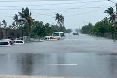
The storm also led to mudslides near the city of Salinas, south of the Bay Area. It caused "mild to moderate" damage to about two dozen rural ranch homes beneath hillsides scorched by the River Fire in August 2020, the Monterey County Regional Fire Protection District told AP.
One woman was treated for broken bones after mud went "completely through the house" in the early morning hours, spokesman Dorothy Priolo said. Fifty horses were rescued.
The storm brought several inches of rain and concerns over burn areas, as well as several feet of snow to high elevations of the region's mountains.
The atmospheric river last week was part of a major shift in weather for California, which had significant drought conditions for months.
The dryness contributed to the worst wildfire season in California’s history. More than 4.2 million acres (17,000 sq km) were scorched in 2020 and 31 people killed.
The climate crisis has increased temperatures in California, meaning moisture evaporates from the land and causes vegetation and trees to burn with far greater intensity once wildfires spark.
Climate scientists predict that climate change will mean less snowfall in the state, storms of concentrated rainfall followed by extended dry periods.
Daniel Swain, a PhD climate scientist at UCLA's Institute of the Environment and Sustainability, told the Tahoe Daily Tribune: "We are losing the cushion we had for wildfire risks."
Dr Kean said that while it is difficult to tie any single event to climate change, there are disturbing trends.
"In the West, the increase in the size and severity of wildfires alone makes more steep terrain vulnerable to debris flows. There are not big changes in the amount of annual precipitation but it's all coming at once. This combination of alternating dry periods with intense periods of rain is a bad scenario for post-fire debris flows."
Wildfires and debris flows are called "concurrent disasters" and the latter can be as dangerous as the original blazes, USGS warns.
Debris flows are caused by a combination of factors. Intense wildfires incinerate trees and vegetation, leaving behind dead matter and loosened soil.
Dr Kean said: "The protective blanket of vegetation, all that binding organic matter that was in the soil even down to fungus, that's gone. So rain can impact the bare soil and it's easier to erode. In an unburned situation, there's a thick blanket of litter and dust which acts like a sponge and that's what helps keep runoff from happening.
"Another factor is that heat from the fire can make the soil water-repellent. There's a variety of reasons for that. One theory is that the heat from the fire vaporizes organic matter, leaving a waxy layer which repels water. So a rush of water on top of a slope makes a slurry which, once it gets started, can get bigger and bigger."
USGS helps state agencies prepare for post-wildfire landslides by making hazard maps. In the past year they have assessed a record 6.5 million acres, an area twice the size of Connecticut. Dr Kean says that because post-fire debris flows start at the surface, they can be easier to predict than a deep landslide.
“We have data and models that can estimate rainfall threshold for the National Weather Service,” Dr Kean said. “Then they look at forecasts and rainfall measurements before a storm impacts a burn area, to see if it’s going to be above or below threshold.
“NWS can issue warnings which they did in the Dolan fire [burn scar] because there was an anticipation of rainfall being above threshold. They shut down Highway 1 before anything happened and that was key to not as big a problem.”
AP contributed to this report. This article has been updated
Join our commenting forum
Join thought-provoking conversations, follow other Independent readers and see their replies
Comments
Bookmark popover
Removed from bookmarks