Satellite photos shows shocking impact of climate crisis in western US
From Lake Mead to the Sierra Nevada mountains, striking images illustrate the extent of the climate crisis
Satellite images have revealed the shocking shrinkage of several lakes in California and Nevada as the US West faces punishing heat and extreme drought conditions.
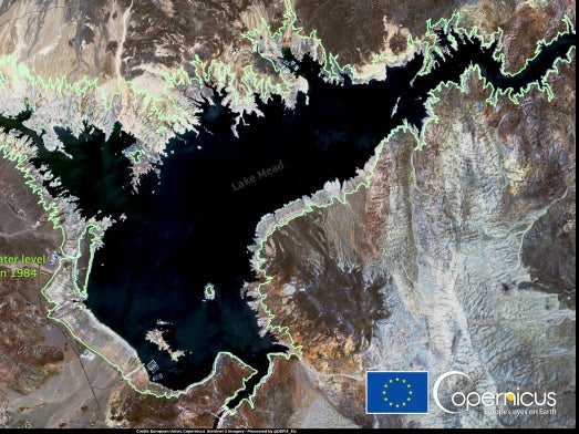
One particular image has revealed the shocking shrinkage of Lake Mead in the last 37 years brought on by the climate crisis. The image was captured by the Copernicus Sentinel-2 satellites on 14 July 2021 and shows the current size of Lake Mead in Nevada.
Data taken from the Landsat-5 satellite was combined with the Copernicus image and compared to the lake's borders in 1984. In the image, a green line represents the lake's boundary in 1984 and shows the significant recession of the lake over the past 37 years.
As of last month, Lake Mead's level had dropped to a third of its total capacity, bringing it to its lowest point in history. Lake Mead is a major provider of water for numerous population centres in the region, and cuts to water allocation for those areas have been planned for 2022.
The shortage has been further exacerbated by the climate change-driven megadrought affecting the Western US.
On top of reducing the water output to downstream population centres, the decline of Lake Mead has also resulted in a reduction of electrical output at the Hoover Dam.
Lake Mead powers one of the country's largest hydropower plants, which provides electricity to 1.3 million people in Nevada, California and Arizona, as well as tribal communities in the surrounding regions.
Patti Aaron with the Nevada Bureau of Reclamation told KTNV Las Vegas that the dam's hydropower efficiency has dropped about 25 per cent due to the lake's shrinkage.
She said that the dam would continue to produce power until the lake drops to 950 feet (290m). Currently the water level is at 1,067 feet (325m).
While the reduction in electricity would be a hurdle for Nevada, the state generates the majority of its electricity through natural gas and nonhydroelectric renewable sources.
In the wake of the lake's decline, a group of activists drawn from conservationists, business people and regional officials representing cities and farming communities have called for an end to the "status quo" management of the Colorado River, which feeds Lake Mead.
Other satellite images from NASA reveal the environmental impact from the severe drought conditions in California.
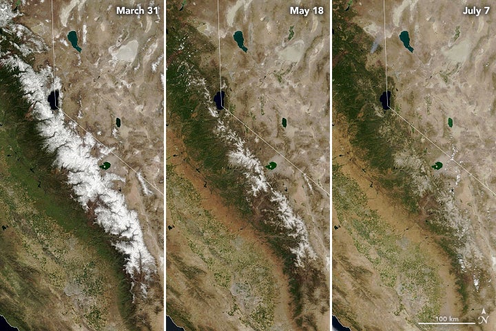
The above NASA image shows the rapid melt of snowcaps on the Sierra Nevada mountains, from March to July 2021. Typically the snowmelt can last deeper into the summer.
“According to state and federal scientists, melting in 2021 in the Sierra Nevada occurred three to four weeks earlier than usual. And that snowmelt did not go far. Parched by two years of drought, the soils between the mountains and the valleys soaked up vast quantities of water,” NASA wrote of the snow melt.
“In a July 8 report, climatologists with the US National Integrated Drought Information System noted that much of California and Nevada are missing 0.5 to 1 years’ worth of precipitation since October 2019, and California is missing more than 1.5 years’ worth of streamflow,” the agency added.
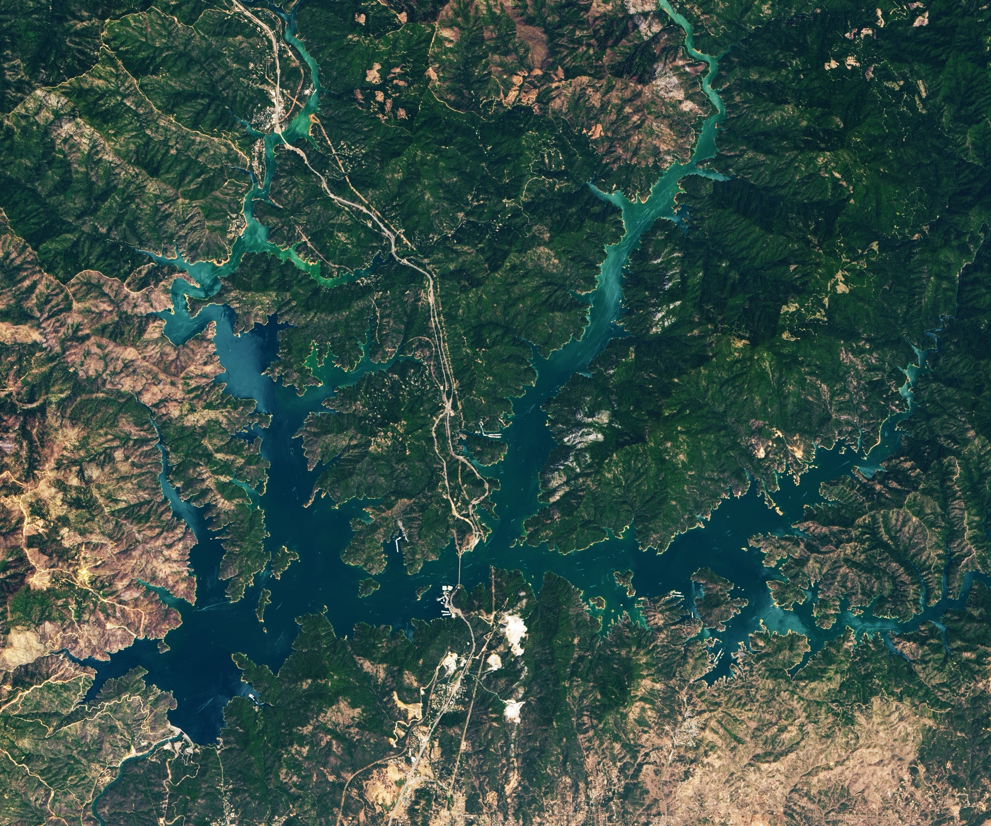
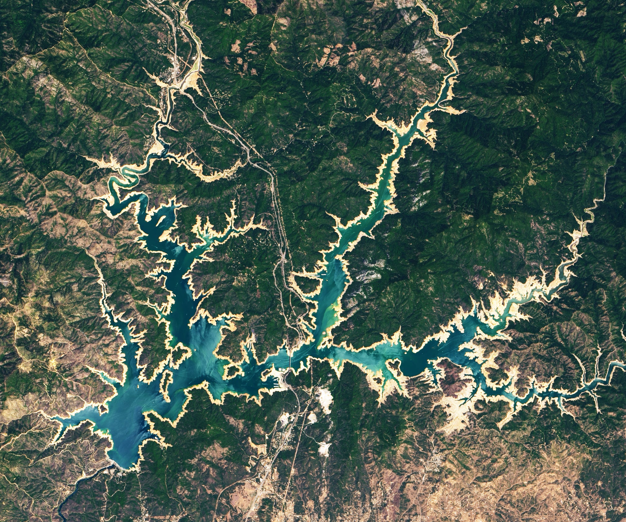
The above images from NASA also show the depleted the water level at Shasta Lake in northern California. According to the agency, Shasta is the largest water reservoir in California, and the state’s third-largest body of water.
“The tan fringes around the water in 2021 are areas of the lakebed that are underwater when the reservoirs are filled closer to capacity. The phenomenon is often referred to as a ‘bathtub ring,’” NASA said in describing the images.
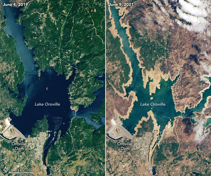
Similarly, Lake Oroville in northern California has seen its water level drop. “From June 2019 to June 2021, the water level on the state’s second largest reservoir fell 190 feet (58 meters), from 895 to 705 feet above sea level,” NASA said, noting that the Associated Press has reported that the lake’s lowest-ever level was 646 feet in 1977.
Join our commenting forum
Join thought-provoking conversations, follow other Independent readers and see their replies
Comments
Bookmark popover
Removed from bookmarks