Potential hurricane headed for Florida weeks after more than 100 killed during Ian
If it reaches Category 1 status, Subtropical Storm Nicole would become one of only a few, rare November hurricanes to hit land
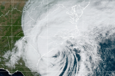
Parts of Florida are under a hurricane watch as a late-season storm moves in from the Atlantic this week.
The storm system, called “Subtropical Storm Nicole” as of Monday morning, is projected to become a Category 1 hurricane on Wednesday as it moves across the Bahamas and toward the Miami area.
Nicole is projected to make landfall in the US on Wednesday night, meaning it is unlikely to have a major impact on Election Day — though some rain could start as early as Tuesday afternoon.
It will also bring another coastal storm to Florida just weeks after Hurricane Ian devastated communities and left more than 100 people dead across the Sunshine State.


Nicole’s impact is likely to result in “storm surge flooding, heavy rainfall and strong gusty winds”, according to the National Weather Service office in Miami.
A hurricane watch has been issued for the northwest Bahamas, the Florida coast from just north of downtown Miami through Brevard County outside Orlando, and the area surrounding Lake Okeechobee. The rest of Florida’s Atlantic coast, as well as parts of Georgia, are under a tropical storm watch.
Along much of the Florida coast, storm surge could reach up to five feet (1.5 metres), the National Hurricane Center (NHC) says. Rainfall in some spots could reach up to six inches (15 centimetres).
Nicole is not expected to get much stronger than a Category 1 storm. But if it hits land as a hurricane, it would be one in a rare set of late-in-the-season storms. Between 1851 and 2017, the average year had less than one tropical storm form in November, according to the National Oceanic and Atmospheric Administration (NOAA).
There have been some exceptional years, however: 2020 featured the highest number of tropical storms ever recorded in the Atlantic including two Category 4 hurricanes — Eta and Iota — that hit land in November.
This year, Hurricane Lisa hit Belize as a Category 1 storm in early November. Another Category 1 hurricane, Martin, formed this month but did not make landfall anywhere.
Hurricane season in the Atlantic usually lasts from early June until the end of November, with activity peaking in September. Nicole is the 14th named storm of the year — and if reaches Category 1 status, it would be the eighth hurricane.
NOAA had predicted an “above-normal” hurricane season, with between 14-20 named storms and six to 10 hurricanes, including three to five hurricanes at Category 3 or higher.
While the season looks like it will end at the lower end of that range, the two major hurricanes that have formed were particularly destructive. In September, Hurricane Fiona, — which eventually reached Category 4 status — slammed in Puerto Rico and other parts of the northwest Caribbean, leaving some places without power for weeks.
Later that month, Hurricane Ian hit southwest Florida as a nearly Category 5 storm, leaving widespread devastation in places like Fort Myers and Cape Coral.
While Nicole is not forecast to have a direct impact on the communities impacted most directly by Ian, it could bring strong winds and heavy rain to parts of the state that got battered earlier this year.
Hurricanes are forecast to become much stronger on average as the climate crisis grows. As the planet heats up, warmer ocean surface temperatures — conditions that can lead to explosive growth in hurricane power — are expected to get a lot more common.
A UN climate science panel has found that a higher percentage of storms are reaching Category 3 or higher, making them even more hazardous if they make landfall.
Join our commenting forum
Join thought-provoking conversations, follow other Independent readers and see their replies
Comments
Bookmark popover
Removed from bookmarks