Tropical Storm Hilary makes landfall, bringing risk of tornadoes and flooding for millions in California
Despite being downgraded from hurricane status, Hilary still poses grave risks, officials warn
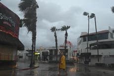
The remnants of Hurricane Hilary made landfall as a major tropical storm in northwestern Mexico on Sunday, bring the risk of heavy rains and flash floods to millions.
The storm hit a sparsely populated area about 150 miles norther of Ensenada, Mexico, according to forecasters.
Even before the centre of the storm began passing over land, Mexico’s Baja peninsula was inundated, with flood waters washing layers of earth over towns like Santa Rosalía.
The extreme weather, expected to pass over Los Angeles on Sunday afternoon, has claimed at least one fatality already, a man in the Mexican state of Baja California Sur who was swept away in a stream on Saturday as he and his family attempted to cross by car, according to officials from the Mulege township.
As of 11am Pacific time, the storm, which was downgraded from a Category 1 hurricane to a tropical storm on Sunday morning, was about 210 miles south-southeast of San Diego, California, according to the National Hurricane Center (NHC).

The centre said in a forecast that the storm means “catastrophic and life-threatening flooding [is] likely over Baja California and portions of the Southwestern US through Monday.”
“Intense heavy rainfall associated with Hilary is expected across the Southwestern United States through early Monday morning,” it added. “Rainfall amounts of 3 to 6 inches, with isolated maximum amounts of 10 inches, are expected across portions of southern California and southern Nevada leading to dangerous to catastrophic flooding.”
A team from the Federal Emergency Management Agency is deployed in California ahead of the arrival of Hilary.
"FEMA urges residents in Hilary’s path to complete preparation for flooding impacts associated with the storm," the agency said in a statement. "Although Hilary is expected to weaken to a tropical storm before it reaches Southern California, it is forecast to bring dangerous to catastrophic flooding across portions of southern California and southern Nevada."
Some areas could see as much of a year’s normal amount of rain in a single day, while heavy weather is expected as far north as Oregon and Idaho.
Ahead of the arrival of the storm, California declared a state of emergency, and evacuations were ordered for communities including Azusa in the San Gabriel Mountains, Santa Catalina Island, and towns and cities in the path of potential flooding in San Bernadino County as well as Orange Counties.
All beaches were closed in San Diego and Orange County.
“Rainfall flooding has been the biggest killer in tropical storms and hurricanes in the United States in the past 10 years and you don’t want to become a statistic,” National Hurricane Center Director Michael Brennan said on Sunday in a public briefing.
The worst of the storm isn’t expected above Los Angeles until late Sunday afternoon, but bands of rain were already causing flooding as of Sunday morning.
The National Weather Service issued a Flood Watch Warning covering the entirely of Los Angeles on Sunday, an area spanning nine million people in LA and outlying communities including Long Beach, Malibu, and the San Fernando Valley.
Cities like San Diego with large homeless populations sought to bring in as many people as possible, establishing emergency shelter beds as the area’s over 10,000 unhoused people faced extra risk being outside in the middle of Southern California’s first tropical storm in 8 decades.
At major air hubs, numerous flights were cancelled because of the weather, including 185 out of Phoenix, 251 out of San Diego, and Southwest canceling all its flights out of Palm Springs.
Hilary is expected to remain a tropical storm then dissipate on Monday as it moves into central Nevada.
Join our commenting forum
Join thought-provoking conversations, follow other Independent readers and see their replies
Comments
Bookmark popover
Removed from bookmarks