UK weather: Flood warning as heavy rain to batter parts of Britain
Showers also expected into Wednesday
The Met Office has issued a yellow weather warning for heavy rain, with floods possible across many parts of the UK.
The forecaster’s warning is across most of the UK until 9pm on Tuesday with possible disruption to buses and rail transport.
The warning has been issued for London and south east England, in addition to Wales, south west England and parts of Scotland.
“Some of the rain will be heavy, with 15-30 mm of rain falling widely and as much as 40-50 mm over parts of Dartmoor and south facing high ground of southern Wales and the Marches and parts of southern England,” the forecaster added.
“Flooding of a few homes and businesses is possible.”


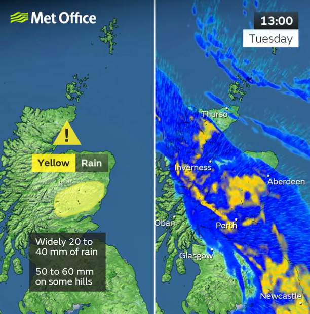
Met Office chief meteorologist Steven Ramsdale said: “Rain will affect much of the UK during the early part of this week, with a weather front on Tuesday bringing heavy rain and strong winds at times.
“Rain on Tuesday is likely to bring some impacts to travel and some possible flooding in places. Parts of southern Wales, southern England and eastern Scotland are likely to see the heaviest and most persistent rain, with over 30mm of rain in some places and some exposed parts of eastern Scotland potentially seeing 50mm.
“It will be a wet day for many however with 10-20mm of rain falling across much of England, Wales and Scotland.”
Showers are also expected into Wednesday as part of an unsettled day. Rain will be most prevalent on southern and western coasts, before low-pressure and a more persistent spell of rain arrives from the west on Wednesday evening, the Met Office said.
Met Office deputy chief meteorologist Helen Caughey said: “Wednesday will start off generally drier for many, albeit with some showery interludes especially around coastal areas in the south and west.
“While there are some differences in timing, there’s a good degree of confidence that low-pressure will move in from the west on Wednesday evening and track northeast through Thursday, clearing the far northeast early on Friday, signalling a return to wetter and windier conditions more widely.”

She added: “This low pressure will bring some heavy rain at times late on Wednesday, with that risk spreading further north on Thursday. High winds are also expected for most, with some coastal gales possible. The strongest winds are most likely in the far northeast of Scotland and the Northern Isles on Thursday, with gusts in excess of 60mph possible.”
According to the Met Office, temperatures will drop through this week back towards average for the time of year, although with the strong winds and rain, this will feel much cooler than the unseasonably mild conditions seen in recent days.
Join our commenting forum
Join thought-provoking conversations, follow other Independent readers and see their replies
Comments
Bookmark popover
Removed from bookmarks