A guide to A-road Britian: A169
As a sampler to the delights of God's Own County, the road from Malton to Whitby is hard to beat. Rachel Shields guides us up through the North Yorkshire Moors and then down to the sea
For a road which cuts through some of the wildest and most beautiful landscapes in the British Isles, tumbling over the rugged gorse-covered hills of the North Yorkshire Moors, the A169 begins somewhat inauspiciously. Branching off the busy A64 from York, just north of the market town of Malton, the narrow road snakes along the valley floor, passing through the picturesque village of Old Malton, before sidling alongside Wykeham, Low Marishes and Marishes.
Although undeniably pretty in the bright summer sunshine, these chocolate -box villages feel worryingly out of place amid such a flat landscape. They seem almost southern. While I must declare an interest - I am a Yorkshire lass, albeit one who has decamped to London - they bear no resemblance to the dramatic wilderness which provided the backdrop to Emily Bronte's passionate love story of Cathy and Heathcliff.
Before I get too downhearted, a large white rose of Yorkshire bears down on us from the wall of one of the many farms which line the road, reminding us we are indeed in what Yorkshire folk, with the modesty for which they are noted, call "God's Own County".Pubs alongside the road advertise homecooked food and beer from the Black Sheep Brewery in nearby Masham, while a garden centre offers 200 varieties of potted roses; presumably available in colours other than white.
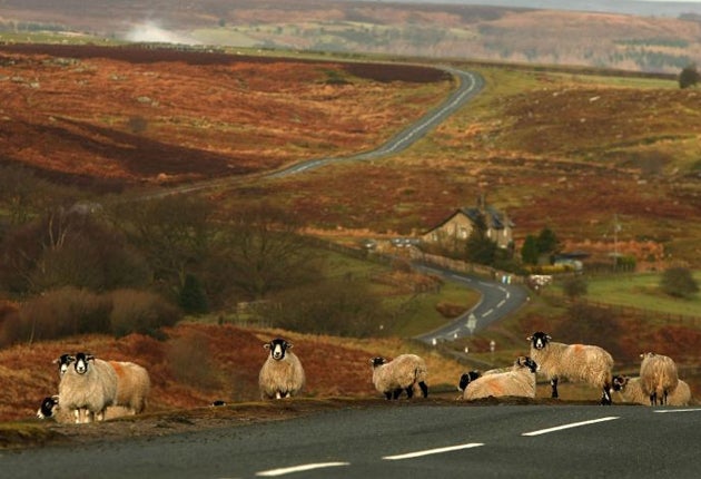
Letters on the asphalt warn drivers to "Slow", but the Highways Agency needn't have any worries on that front, as the numerous tractors pootling along this section of the road limit traffic speed more effectively than any camera could.
Passing through the market town of Pickering, whose origins can be traced back to 270BC and which boasts a castle in which Richard II was imprisoned, the road enters the North Yorkshire Moors, and the really great driving begins.
The road winds upwards, offering drivers a progressively better view over great swathes of brown, green and mustard-yellow moorland. At the crest of the hill the land immediately to the west falls away into a spectacular amphitheatre 120 metres deep and a kilometre wide, known as "The Hole of Horcum". Local legend has it that the hole was made by the giant Wade, who picked up a clod of earth and threw it at his wife, making both the hole and nearby Blakey Topping, where it landed.
Cars park along the top where people take in the view and the vehicles dispense walkers in bright coloured anoraks.
The road then descends, tracing a delightful sweeping curve before meandering back up to the top of Snod Hill where the radar base, RAF Fylingdales, is perched to provide early warning of ballistic nuclear missiles. Set back to the west, the white pyramid-shaped tracking centre replaced the famous "golf balls" back in 1992. This stretch is largely uncrowded, but the snaking curves of the largely empty road prove too tempting for some drivers and motorcyclists, who tend to use it as a race track.
Plumes of smoke curl up between the thick trees to the east; a romantic reminder of the steam trains still chugging along the North York Moors Railway.
The line runs parallel to the A169 for nearly 15 miles, from Pickering to the village of Grosmont, and is so reminiscent of The Railway Children that one half expects to see a girl waving a red petticoat.
This feeling of having driven back in time is complete when, 12 miles from Pickering, the road drifts past Goathland where they filmed the TV series Heartbeat, which is set in the 1950s.
As the road creeps up on to Blue Bank just six miles from Whitby, a panoramic view of the coastal town fills the windscreen, taking in everything from the 13thcentury abbey on the cliffs to the famous sailors' church of St Mary, and the sea stretching ahead. Just a moment later, the road drops from the moors in a satisfying long, steep descent into the village of Sleights. Weaving past picture perfect houses, pubs and the Botham & Sons Bakery, you then cut across the babbling River Esk before blending seamlessly into the A171 for the final stretch into Whitby.
As Britain's A-roads are numbered in order of importance - the lower the number, the more significant the road - the A169 clearly isn't a vital part of the country's transport network. But as a unique window into Yorkshire culture - taking in everything from the county's stunning moorland, to its characterful villages and coastline - it is unrivalled.
Join our commenting forum
Join thought-provoking conversations, follow other Independent readers and see their replies
Comments
Bookmark popover
Removed from bookmarks