Historic 240-year-old nautical map shows damage to Florida's coral reefs far worse than feared
Navigational charts by 18th century British Admiralty surveyor George Gauld suggest decimation of marine life off Keys more severe than previously thought
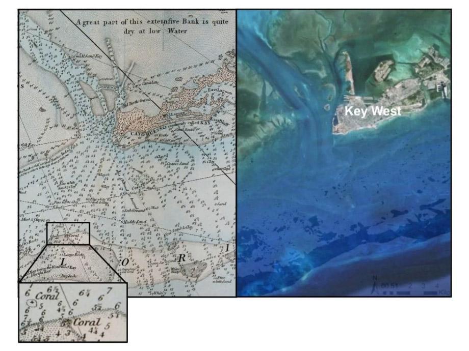
Between 1773 and 1775, George Gauld, a surveyor with the British Admiralty, immortalised the coast of the Florida Keys in ink. Though his most pressing goal was to record the depth of the sea - to prevent future shipwrecks - Gauld embraced his naturalist side, too. He sprinkled his maps with miscellany that later charts would omit: where sea turtles made their nests, or the colours and consistency of sand.
Gauld also took note of the corals he saw. And in doing so he created the oldest known records of Florida reefs.
“With the early charts you can actually see the reef itself being drawn,” said Loren McClenachan, a marine ecologist at Colby College in Maine. “It matches almost exactly with the satellite data.” In a study published Wednesday in the journal Science Advances, McClenachan and her colleagues compared those 240-year-old observations with present-day satellite images.
A stark picture of shrinking coral emerged: Half of the reefs recorded in the 1770s are missing from the satellite data.
The coral nearest to shore fared the worst, with 88 percent of the coral that Gauld recorded now gone. At the fore-reef, the coral at the most seaward edge of the reef, there appeared to be no loss between historical coral observations and modern habitat maps. “I was surprised that there was such a strong spatial gradient,” McClenachan said.
“It's a very important study,” said Sam Purkis, a marine geoscientist and conservationist at the University of Miami who was not involved with this research. The maps are old and were “generated with very primitive techniques,” he said. (Where modern biologists will use satellites or hop into the sea to observe coral, surveyors such as Gauld dredged up seafloor samples using rope tipped with tallow or wax pockets, the study authors wrote. Or they simply looked.)
Katie Cramer, a researcher at the Scripps Institution of Oceanography in San Diego, pointed out a few possible limitations with the maps: It's impossible to tell whether the surveyors distinguished between living and dead coral, for example, or how long the reefs had persisted.
Despite such limitations, dismissing these charts, Purkis said, would be “overlooking a very rich data source.”
The causes of modern coral deaths are widespread, McClenachan said, such as more-acidic oceans and higher water temperatures. But these newfound sharp losses were local. As for the exact reasons for the disappearance of the Florida corals, “we can't get at that,” she said. “All we have is then and now.”
But the marine ecologist offered a few possible explanations, most of them involving humans. Humans built a causeway through the Keys and dredged the Key West harbour. We've changed the way fresh water flows through the Everglades. Perhaps agriculture played a part. In Panama, where studies of fossilized coral show similar near-shore population drops, ecologists suspect that the appearance of banana plantations degraded water quality.
Land-based pollution and fishing were older sources of coral destruction, said Cramer, who has studied the paleoecological history of reefs. “Corals began dying in other parts of the Caribbean shortly after the establishment of industrial agricultural operations,” Cramer said. What's more, she said, “the historical loss of algae-eating fish such as parrotfish has likely caused a decline in coral growth rates.”
“There are many factors, some natural, some anthropogenic,” Purkis said. He did not rule out human involvement, but he also noted that the local sea level has been rising since the 1930s. The rising seawater sweeps out mangrove and saw-grass debris as well as sediment, he said, which can choke coral.
Looking at older ecological records helps redefine what we think of as a natural baseline - particularly in marine environments, McClenachan said, where we don't have a lot of historical information. She said she doesn't consider the Florida losses to be isolated. And we might not know how severe other local coral population declines have been. “If something's not there, you don't know to look for it,” she said.
“Even the oldest surviving generations probably cannot remember seeing spectacular reefs close to shore in Florida,” Cramer said, “so we have lost our collective memory of the majesty of these reefs and a sense of the magnitude of what has been lost.”
Purkis said this long time scale offers a look into not only the past but also the future. If deeper corals are the most historically resilient, for instance, perhaps they deserve special attention. “If we think about protecting reefs in the future, with no-take zones and marine protected areas, we might learn about where our more sensible conservation efforts can be,” he said.
After all, Floridians might want these ecosystems to stick around for another 240 years: The global biodiversity of reefs is estimated to be worth billions. Fish, including many species that end up on dinner plates, spawn and grow around coral. And, with storms such as Hurricane Irma on the horizon, it's important to recognise that reefs protect landlubbers by blunting waves before they can strike the coast.
The Washington Post
Join our commenting forum
Join thought-provoking conversations, follow other Independent readers and see their replies
Comments
Bookmark popover
Removed from bookmarks