Rare pink fog descends on the UK as Met Office issues weather warnings across the country
A number of flights to and from London City Airport have been cancelled
Many Britons woke up on Wednesday to find a pink fog had descended in a rare weather phenomenon.
People in London and the southeast of England reported seeing the rosy skies, which occurs when sunlight passes through layers of fog during sunrise or sunset.
The Met Office explains that when the sun is low on the horizon, its light travels through more of the atmosphere.
Because fog is essentially a cloud at ground level made up of tiny water droplets, shorter wavelengths (blue and green light) are scattered out, leaving the longer red wavelengths to dominate.
When this filtered light shines through fog, it gives the fog a pink or rosy hue, which is “purely an optical effect it does not indicate any unusual weather hazard beyond normal fog risks, such as reduced visibility”.

The blanket of pink fog comes as forecasters are warning of potential flight disruption and cancellations after fog alerts were issued across London and other parts of the UK.
The Met Office has said parts of the country have seen “dense fog” on Wednesday with visibility as low as 100m in places, causing a number of flight cancellations and delays.
Thousands of passengers are experiencing disruption after seven flights to and from London City Airport were cancelled. Flights inbound to Southampton have also been heavily delayed by the fog.
It comes as low-pressure systems move across the UK, bringing unsettled weather, fog and heavy showers. Forecasters warned the weather could lead to “difficult travel conditions”, particularly across the east Midlands and Cambridgeshire.
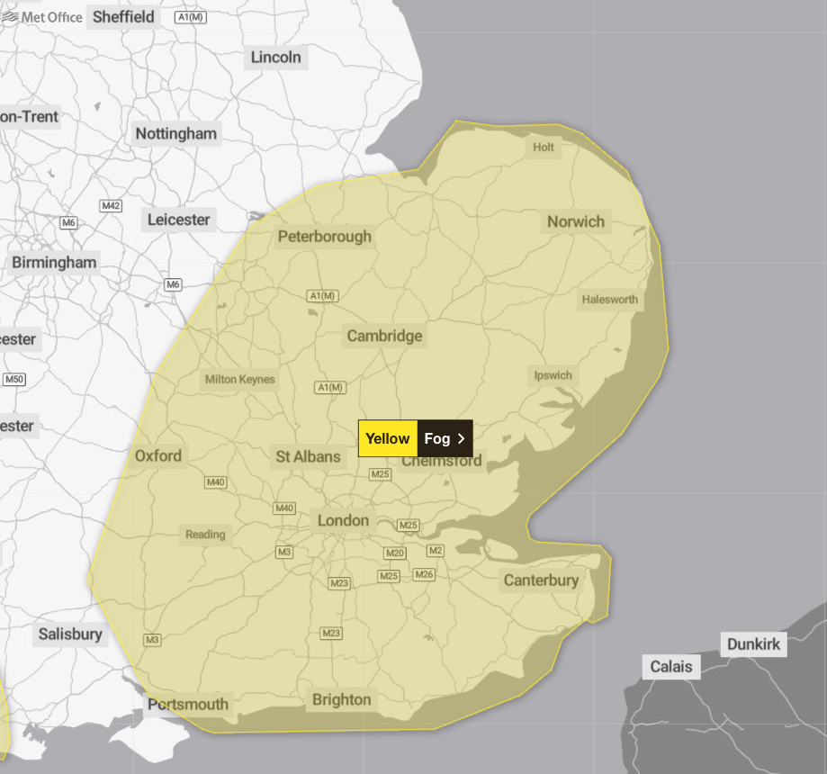
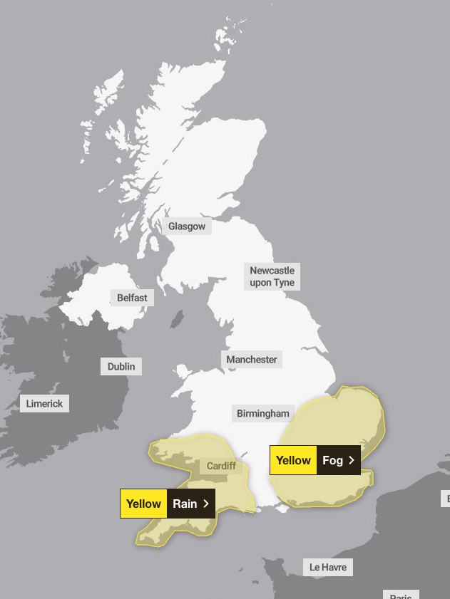
A yellow weather warning for fog was in place this morning covering south-east England and the east Midlands, while a yellow warning for rain has been issued in the South West.
The fog warning was in place until 10am on Wednesday, but it is still impacting flights in and out of London City Airport. Its runway is only 19ft above mean sea level, is adjacent to the River Thames and is often affected by poor visibility.
Gatwick Airport told The Independent that no flights have been impacted by the fog.
In the South West and south Wales, a yellow warning for rain is in place until 11.59pm on Wednesday. Forecasters have warned that heavy rain, especially over high ground, may cause travel disruption and flooding.
The Met Office said 10 to 20mm of rain is likely widely, with 40 to 60mm possible over Dartmoor and the hills of south Wales.
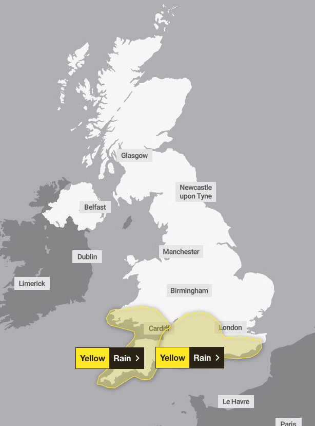
Heavy rain is expected to push eastwards on Thursday. Forecasters have issued a yellow weather warning for rain across south-west England and south Wales until 7pm, and a separate yellow warning for the southern counties of England between the hours of midnight and 9pm.
It added that within this warning area, 15 to 25mm of rain is possible widely, with 40 to 60mm possible over the Downs.
Forecasters urged people to check road closures and travel disruptions ahead of journeys and prepare for strong winds, particularly in coastal areas.
Neil Armstrong, chief forecaster at the Met Office, said: “We’re set to see an unsettled week as low-pressure systems push fronts across the UK. With recent heavy rain, further wet conditions will increase the risk of flooding.
“With that in mind, it’s important to stay up to date with the latest Met Office forecast and warnings and remember to never drive through floodwater.”
Looking ahead to Christmas week, Mr Armstrong said another low-pressure system could bring further rainy and unsettled conditions over the weekend before higher pressure takes over.
The Met Office said drier and milder weather is expected as we move closer to Christmas Day next Thursday, with some frost and mist overnight.
UK five-day weather forecast
Wednesday
Outbreaks of heavy rain and brisk winds will move eastwards through the day on Wednesday, with southeast England staying dry until after dark.
A yellow warning for rain is in place all day on Wednesday for south-west England and south Wales. Heavy rain, especially over high ground, may cause travel disruption and flooding. 10 to 20mm of rain is likely widely, with 40 to 60mm possible over Dartmoor and the hills of south Wales.
Thursday
Heavy rain is set to move north-east across much of the country on Thursday, with a further yellow warning for rain in place across south-west England and south Wales through the day.
A separate yellow warning for rain is in place for the southern counties of England between midnight and 9pm. Within this warning area 15 to 25mm of rain is possible widely, with 40 to 60mm possible over the Downs. Strong winds are expected too, gusting over 50mph in exposed coastal areas, which may exacerbate impacts.
Friday and the weekend
Friday will bring frequent blustery showers, typical for the time of year, with a brief calmer spell before another low-pressure system arrives. This could bring further heavy rain and unsettled conditions into the weekend.
Join our commenting forum
Join thought-provoking conversations, follow other Independent readers and see their replies
Comments
Bookmark popover
Removed from bookmarks