UK weather: Snow and ice warnings as cold snap returns with -4C Arctic freeze
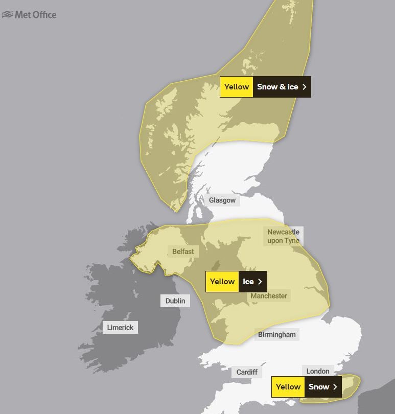
The Met Office has issued a yellow warning for ice in a wide belt across the centre of the UK
Snow and ice warnings have been issued for large parts of the UK as temperatures are set to plunge well below zero.
The Met Office has issued four days of warnings starting on Sunday, as Arctic winds see the return of the pre-Christmas cold snap.
Monday is expected to be the worst affected day of the week, with warnings for snow in the South East and Scotland, and ice warnings for northern England and Northern Ireland.
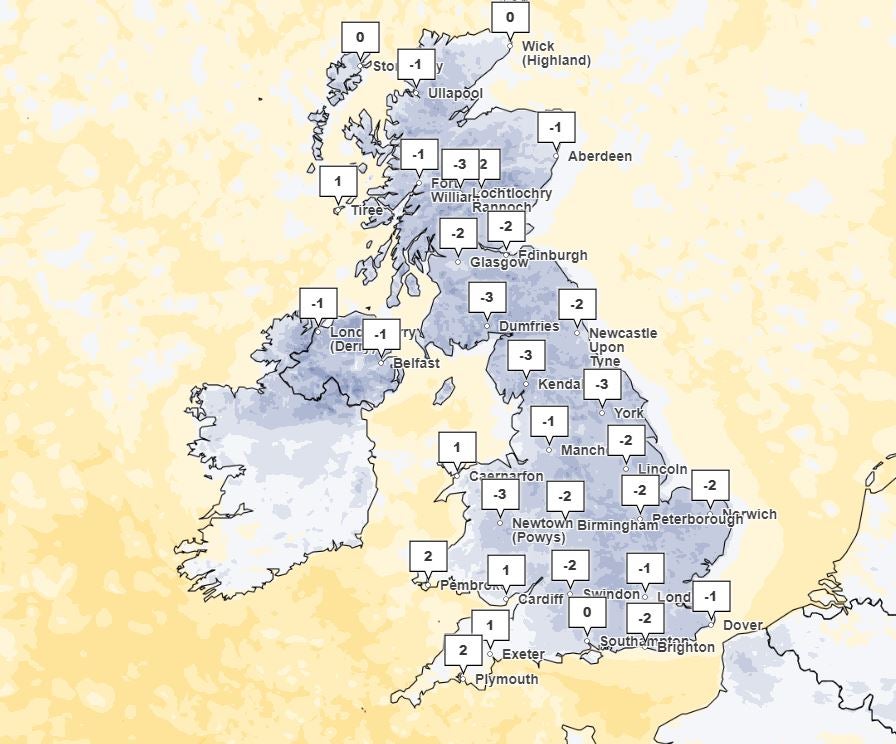
Temperatures are set to drop as low as -4C overnight, struggling to get above 5C during the day.
The first alert, which warns that wintry showers will lead to difficult driving conditions due to slippery surfaces, is in place from 6pm on Sunday until 10am on Monday.


A lengthy yellow warning for snow and ice across northern Scotland begins at 2pm on Sunday through to 10am on Wednesday.
And another warning for snow across parts of southeast England has been issued by the forecaster for Monday, lasting from 2am until 8am.
Residents are urged to take care as there may be icy patches on untreated roads, pavements and cycle paths, and some roads and railways are likely to be affected by longer journey times.
Met Office meteorologist Craig Snell warned those driving to work on Monday to leave plenty of time for their journeys, as the worst of the ice is expected to be during rush hour.
“We are starting to see the cold weather coming in from the Arctic, so we have now started to issue warnings for snow and ice across the UK,” he said.
“We have got a couple of areas we are keeping a very close eye on – we could well see some wintry showers develop tonight across the middle band of the UK, with a risk of snow on high ground and slippery surfaces on lower areas.
“This could be a problem during rush hour, it could cause a few problems on the roads. The risk of flooding is still there.”
Mr Snell added that while “cold and wintry weather” is set to “dominate the UK” throughout the week, the weekend looks milder. “Compared to the cold spell in December, it doesn’t look like it’s going to last as long,” he said.
The Met Office has said overnight temperatures will dip below 0C for much of the UK, while sheltered glens and high areas of Scotland could see -10C.
More than 100 flood warnings are still in place across the UK. Earlier, flood defences, including boarding, were deployed in York city centre.
City of York Council said it had taken the measure to keep the area “safe and open” as it urged visitors to plan their journeys in advance.
Rescue workers were seen using a boat to navigate floodwater in the centre of York after the Ouse burst its banks.
The Environment Agency had issued 98 flood warnings and 180 flood alerts in England as of Sunday morning.
Meanwhile, the Scottish Environment Protection Agency has issued three flood warnings for areas of the Scottish Borders, Tayside, and Ayrshire and Arran, along with two milder alerts for west-central Scotland.
Met Office outlook
Sunday
Bright or sunny spells are possible at first, turning cloudier later. Dry for most, but the odd outbreak of rain is possible in the far north and west. Feeling cold, particularly in strong winds during the morning. Maximum temperature 7C.
Sunday night
Rain will move eastwards in the early hours of the morning, turning heavy at times in the south and perhaps falling as snow over hills. Windy along the south coast. Minimum temperature 0C.
Monday
Overnight rain and hill snow will quickly clear, leaving a cloudy day with the chance of the odd shower during the afternoon. Feeling cold, with strong winds along the south coast. Maximum temperature 4C.
Tuesday to Thursday
Feeling cold throughout, with widespread sharp overnight frosts and ice risk. Dry with sunny or clear spells. Breezy at times.
Bookmark popover
Removed from bookmarks