More than 120 million set to get drenched this weekend as coastal system hammers East Coast
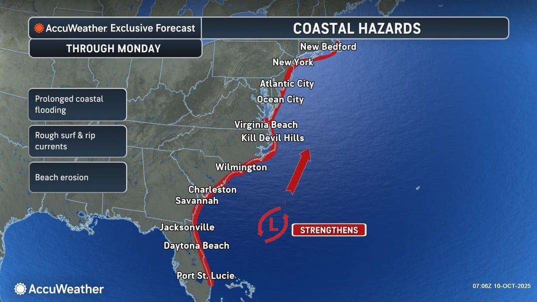
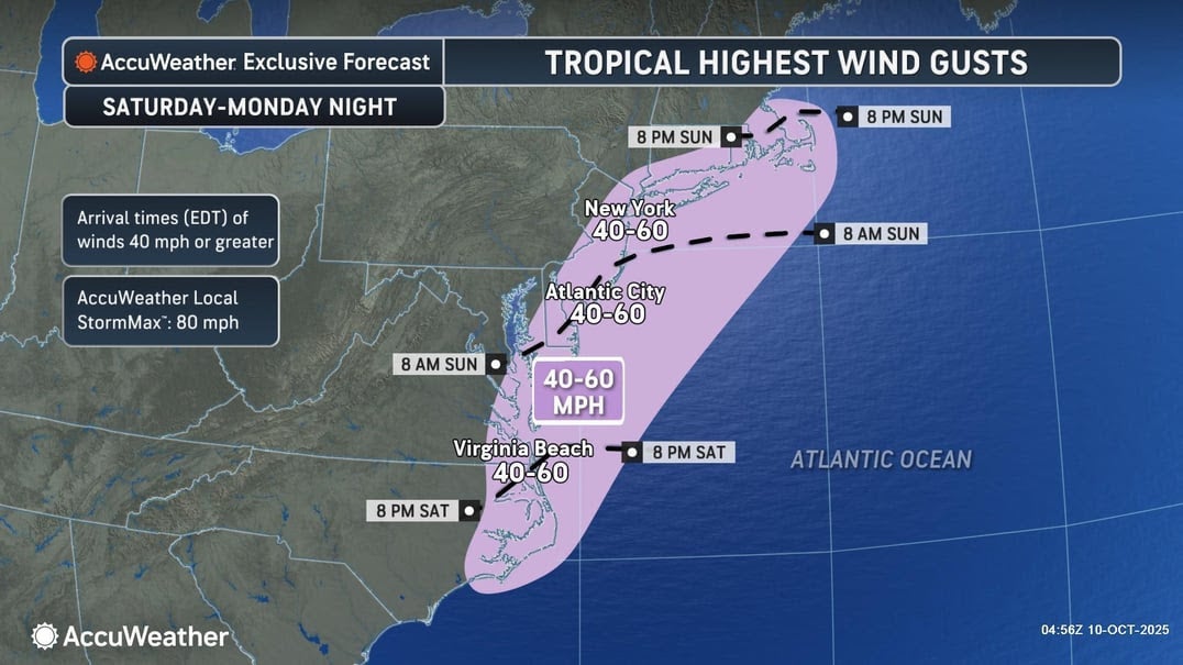
The storm is expected to impact travel up and down the East Coast, bringing gusting winds up to 60 miles per hour and major coastal flooding
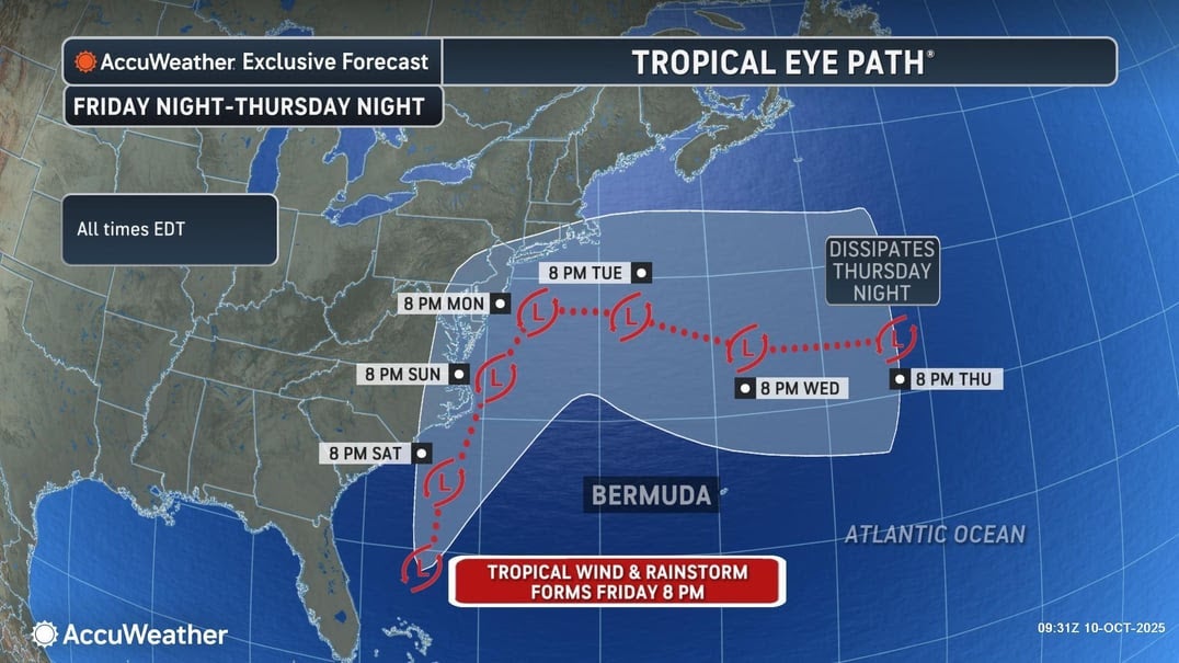
A strong coastal storm is expected to hit the southeastern U.S. on Friday night, impacting around 120 million Americans until early next week.
Heavy rainfall, strong winds gusting up to 60 miles per hour, dangerous rip currents and widespread coastal flooding will likely sweep areas up and down the East Coast.
"This will be a damaging storm for some along the Atlantic coast," AccuWeather Chief On-Air Meteorologist Bernie Rayno said.
The low-pressure system is forecast to form along Florida’s eastern coast, moving northward over the weekend.
The system comes following a quiet Atlantic hurricane season, with only one storm making landfall in the U.S. last July.

Florida
Florida was already flooding amid high tides on Thursday night, with at least one vehicle becoming trapped.
The National Weather Service in Miami said storms had dumped heavy rain across the state’s southwestern region, and the Tampa office warned winds could gust up to 30 miles per hour on Friday.
The low-pressure system is forecast to develop today along Florida’s eastern shores before moving up the Southeast Coast on Saturday and into North Carolina, where it is set to produce showers and thunderstorms.
The Carolinas
A coastal flood warning was in effect for all South Carolina beaches on Friday, and major flooding was projected to affect travel in Charleston and Colleton Counties.
Residents already reported flooding from high tides in Horry County, but a pier there could see a historic crest due to the storm.
“Based on the forecast, a crest of 8.5 feet would land in the top 10 highest historic crests for Springmaid Pier! Elsewhere, minor coastal flooding is expected,” the Wilmington National Weather Service office wrote.
Areas from Beaufort County to McIntosh County and Tidal Berkeley County are slated to see moderate flooding and winds in the state are gusting over 20 miles per hour.
In North Carolina, forecasters in Wilmington said between two and four inches of rain are anticipated to fall along the coast. Strong winds were expected to lead to high impacts from coastal flooding through Sunday night.
Parts of the Outer Banks could see up to four feet of flooding through Monday, with as many as five inches of rain through Sunday in that area. Wind gusts could reach around 45 miles per hour.
The Mid-Atlantic
Coastal flood advisories were issued for the lower Chesapeake Bay, lower James River, and Currituck Outer Banks on Friday morning.
In Virginia, winds along the coast may reach speeds up to 55 miles per hour on Saturday night and into Sunday, which may result in isolated power outages.
The National Weather Service’s Weather Prediction Center said there was a slight risk for excessive rainfall over parts of the Mid-Atlantic coast from Saturday and into Sunday morning.
“The associated heavy rain will create mainly localized areas of flash flooding, with urban areas, roads, small streams, and low-lying areas being the most vulnerable,” it said.
In Delaware, a coastal flood watch was also in effect from Sunday through Monday and extremely rough waters are expected within the Delaware Bay.
“Significant beach erosion and dune breaching is possible due to very high surf. Now is the time to prepare your property for the threat of coastal flooding,” the National Weather Service in Mount Holly urged.
The Northeast
“We are expecting a coastal storm beginning early Sunday morning with the potential to bring severe flooding,” New Jersey Governor Phil Murphy wrote. “Remain alert and monitor your local weather.”
As many as three to five inches of rain may fall in coastal areas of New Jersey and New York, and a high wind watch was issued for New York City on Sunday through early Monday morning.
It is forecast to continue up the East Coast before turning on Monday and Tuesday, according to AccuWeather.
Join our commenting forum
Join thought-provoking conversations, follow other Independent readers and see their replies
Comments
Bookmark popover
Removed from bookmarks