"Frankenstorm" hybrid may be created as Sandy nears East Coast

Hurricane Sandy will probably grow into a "Frankenstorm" as it nears the Northeast early next week with wind and rain that may cause millions of dollars in damage anywhere from Washington to New York and Boston.
Sandy, a Category 2 storm with winds of 105 miles (169 kilometers) per hour, will begin to transform into a hybrid system as it closes in on the East Coast, said Tom Downs, a forecaster at Weather 2000 Inc. in New York.
"The guys in the government are calling it 'Frankenstorm'" because it will be a hybrid between a tropical system and a nor'easter, Downs said. "It is safe to say that there will be millions of dollars in damage."
Sandy was 25 miles east of Great Exuma in the central Bahamas as of 1 p.m. New York time, according to a National Hurricane Center advisory. It was moving north at 20 mph on a wobbling track that nears New Jersey on Oct. 30.
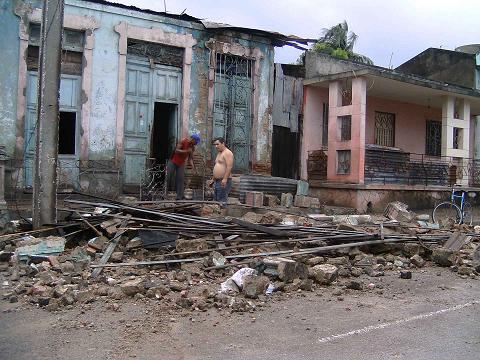
Sandy damaged at least 3,000 homes in eastern Cuba, along with coffee and tomato crops, according to Air Worldwide, a catastrophic modeling firm in Boston.
On Jamaica, where Sandy hit Wednesday, 70 percent of the island lost power, roofs were torn from off homes and roads were blocked by downed trees and floods, according to Air Worldwide.
A hurricane gets its power from warm ocean waters, while a nor'easter gains strength from differences in air temperature, Downs said. Sandy, a big, warm tropical system, is going to collide with cold air and low pressure along the eastern U.S., combing the elements of both.
"So this is going to be a hybrid storm with wind flow over a wider area than a hurricane," Downs said by telephone. "You're not going to experience the massive damage in a concentrated area. Any damage is going to be more widespread but it isn't going to be as catastrophic as a hurricane."
The amount of damage the East Coast is going to absorb is hard to estimate because the storm's track is in a state of flux, said Tom Larsen, senior vice president and product architect at Eqecat Inc., a risk modeler in Oakland, Calif.
Larsen said he doesn't expect Sandy to be worse than Irene, which struck the East Coast in August 2011, killing at least 45 people and causing at least $15.8 billion in damage, according to the hurricane center.
"Right now, in terms of loss levels, Irene is the best kind of guideline," Larsen said. "It doesn't look to be a whole lot worse than Irene."
Because weather models keep changing, Sandy's official track will change as well, Downs said. The hurricane center warns that tracks are just estimates and subject to change.
"Regardless of the exact track of Sandy, it is likely that significant impacts will be felt over portions of the U.S. East Coast through the weekend into early next week," Michael Brennan, a senior hurricane specialist at the center in Miami, said in a forecast analysis.
The storm may hit anywhere from the mid-Atlantic states starting Oct. 28 to southern New England later in the week, said Gary Best, a meteorologist for Hometown Forecast Services Inc. in Nashua, New Hampshire.
"A very complicated situation is going on right now," Best said by telephone. "As it moves across the western Atlantic, it is going to encounter a dip in the jet stream. There will be a lot of energy coming in from the West and it may try to capture the storm and pull it into the U.S. coastline."
New York City has a 55 percent chance of winds of at least 39 mph by Oct. 30, according to estimates by Tropical Storm Risk, a consortium of experts on insurance, risk management and climate supported by the British government.
Cold air over the Appalachian Mountains may mix with the moisture and drop several inches of snow, Best said. The cities along the East Coast will probably have rain.
— With assistance from Jim Polson and Henry Goldman in New York, Lynn Doan in San Francisco, Yee Kai Pin in Singapore and Julie Johnsson in Chicago.
Join our commenting forum
Join thought-provoking conversations, follow other Independent readers and see their replies
Comments
Bookmark popover
Removed from bookmarks