Tracking Hurricane Lee: What is the path of the monster storm?
Here is everything we know about Hurricane Lee and where it may be heading
A storm that has now intensified to a Category 5, is "rapidly strengthening" as it stirs through the Caribbean, the US National Hurricane Center reported on Thursday.
Hurricane Lee began to strengthen over the very warm waters of the Atlantic, growing from a tropical storm into a Category 1 hurricane on Wednesday and by late Thursday night, it had grown to Category 5, with maximum sustained winds of 160mph.
By Friday morning, forecasters said Lee could become a “monster 180mph” storm.
Forecasters report that the storm could reach its peak by this weekend and is expected to be a vicious hurricane over the southwestern Atlantic by next week.
The NHC said “dangerous surge and life-threatening rip currents are likely in the northern Leeward Islands beginning Friday” and move along most of the US East Coast on Sunday.


Here is everything we know about Hurricane Lee and where it may be heading
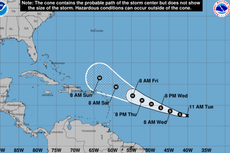
Where is Hurricane Lee heading?
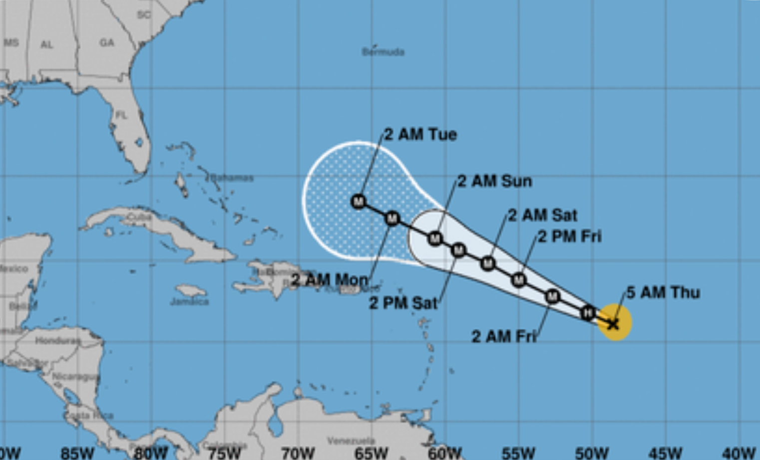
The National Hurricane Center has said the storm will be moving in the following direction:
This weekend and early next week, the storm will progress to move north of the northern Leeward Islands. It said the conditions will impact the Virgin Islands, and Puerto Rico.
On Friday, the rip currents will spread westward, affection Puerto Rico, Hispaniola, the Turks and Caicos and the Bahamas through the weekend.
On Sunday morning, the “dangerous” surf and rip currents will churn along most of the US Coast.
The agency has advised people to check with local weather offices for more information.
AccuWeather meteorologist Bernie Rayno told USA Today, "Right now, the area in the United States that really needs to pay attention includes locations from the Outer Banks of North Carolina up to the Northeast."
Where will hurricane Lee make landfall?
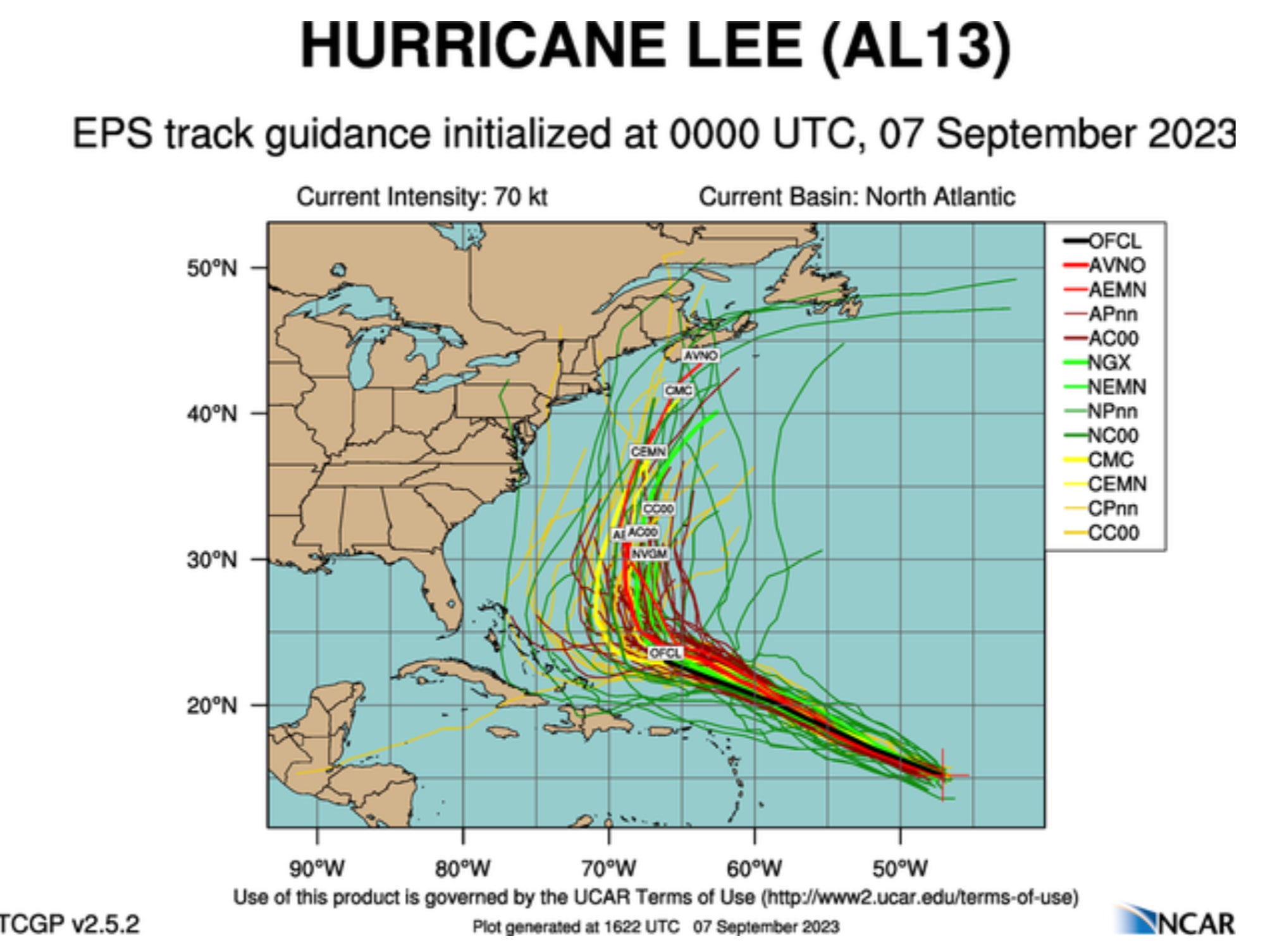
It is too early to tell, according to a CBS News forecaster – but there a few possible scenarios.
One theory involved a cold front coming off the East Coast that could trap Lee and push it north against the coastline, bringing potentially stormy weather to areas along the coast.
However, if no cold front were to form, the forecaster explained that Lee would then potentially stay out at sea for a longer period until it were to reach Newfoundland and Labrador in Canada . At this point it may have significantly weakened, theCBS report said.
Dr Levi Cowan PhD in meteorology from Florida State University, wrote on X, formerly known as Twitter that this he was most “impressive rapid intensification episodes” in the Atlantic.
He added: “This is one of the most impressive rapid intensification episodes I’ve ever seen in the Atlantic. Hurricane #Lee went from having no eye this morning to possibly Cat 5 intensity this evening. Absolutely incredible.”
What is a category 5 and what are some of the strongest hurricanes ever recorded in Atlantic basin?
Storms are ranked from one to five on what is called the “Saffir-Simpson Hurricane Wind Scale”.
According to the National Hurricane Center, Category 5 is the highest and when “catastrophic damage will occur.”
“A high percentage of framed homes will be destroyed, with total roof failure and wall collapse. Fallen trees and power poles will isolate residential areas.
“Power outages will last for weeks to possibly months. Most of the area will be uninhabitable for weeks or months,” the agency said on its website.
Here are some of the strongest hurricanes ever recorded in the Atlantic basin:
The Labor Day Hurricane in 1935 – After a reanalysis by National Oceanic and Atmospheric Administration, it was found that the maximum sustained winds were at 185mph which it made landfall in the central Florida Keys.
Hurricane Allen in 1980 – the cyclone started in the central Atlantic and ravaged its way in the Caribbean - winds were estimated to have reached 190mph, according to Fox Weather.
Hurricane Wilma in 2005 – This storm, now listed in the Guinness World Records are the “lowest barometric pressure in the eye of an Atlantic hurricane” – but despite the low-pressure winds hit around 185mph and has been listed as one of the most intense cyclones ever recorded.
Additional reporting from agencies
Join our commenting forum
Join thought-provoking conversations, follow other Independent readers and see their replies
Comments
Bookmark popover
Removed from bookmarks