Hurricane Willa: 'Extremely dangerous' storm over Mexico's Pacific coast grows to Category 5 strength
Forecasters predict 'life threatening storm surge, wind and rainfall'
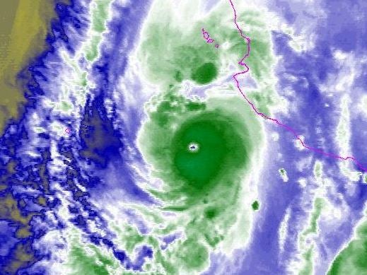
Hurricane Willa has grown rapidly into an “extremely dangerous” Category 5 storm which could smash into Mexico’s western coast over on Tuesday, forecasters have warned.
The US National Hurricane Center said it could “produce [a] life threatening storm surge, wind and rainfall” over portions of the Central American country’s south and central west.
Category 5 is the highest classification for hurricanes.
The storm is expected to make landfall between the resort towns of Mazatlan and Puerto Vallarta late Tuesday or early Wednesday.
A hurricane warning has been posted for Mexico’s western coast between San Blas and Mazatlan.
Tropical storm warnings have also been raised from the beach area Playa Perula to San Blas and also north of Mazatlan to the bay of Bahia Tempehuaya.
Willa had maximum sustained winds of 155mph in the early hours of Monday morning, which extended over 15 miles out of the storm’s core.
Tropical storm force winds were spread even wider, at 55 miles out from Willa’s core.
Forecasters said 15 to 30.5cm of rain should fall over parts of Mexico’s western Jalisco, western Nayarit and southern Sinaloa states
Some areas could see up to 46cm of rainfall, increasing the danger of flash flooding and landslides in mountainous areas.
Tropical storm Vicente, which is separate to WIlla, is expected to weaken to a tropical depression over the south of Mexico.
It is still likely to produce heavy rainfall and flooding in parts of southern and southwestern Mexico.
Forecasters said the storm could produce an additional 7.5 to 15cm of rain across Mexico’s Guerrero, Michoacan, Colima and Jalisco states.
Additional reporting by agencies
Join our commenting forum
Join thought-provoking conversations, follow other Independent readers and see their replies
Comments
Bookmark popover
Removed from bookmarks