‘Lost’ ancient Mexican city had as many buildings as Manhattan, laser map shows
'If you do the maths, all of a sudden you are talking about 40,000 building foundations up there'
A "lost" Mexican city built by rivals to the Aztecs has as many buildings as Manhattan and was home to around 100,000 people, according to new research.
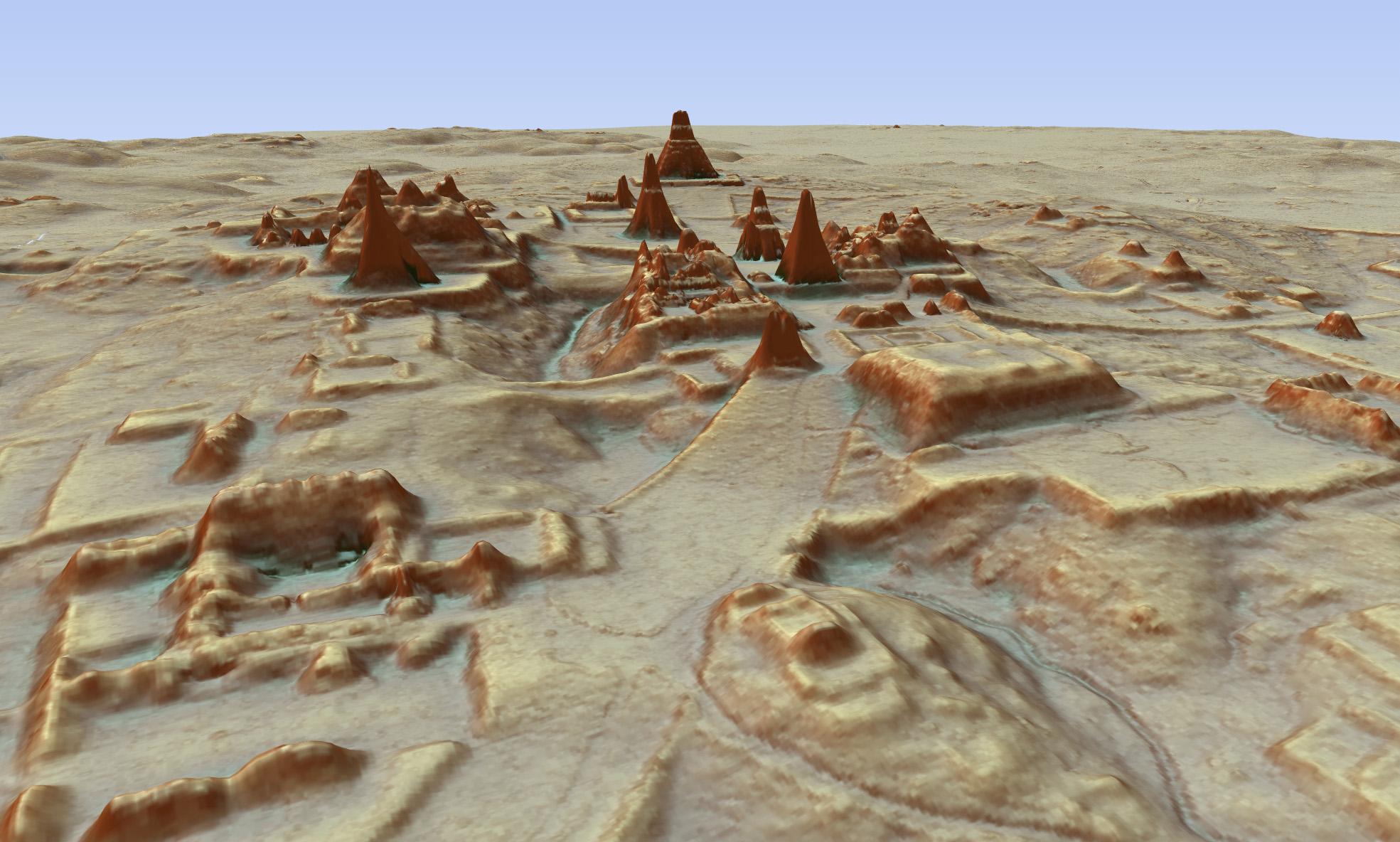
The sprawling urban centre of Angamuco which was part of the Purépecha empire that peaked in the 16th century was detected by an aerial laser mapping technique called the Lidar system.
An aircraft beamed out laser pulses and experts later examined the signals that bounced back from the ground, which helped them pull together a 3D map of the city near modern day Morelia in the state of Michoacan in western Mexico.
It revealed Angamuco covered an area of more than 10 square miles, complete with monuments such as pyramids, temples, plazas and road systems.
“To think that this massive city existed in the heartland of Mexico for all this time and nobody knew it was there is kind of amazing,” archaeologist Chris Fisher told The Guardian.
The Purepecha were a major civilisation which peaked in the 16th century, with its capital Tzintzuntzan also located beside Lake Patzcuaro in western Mexico.
Mr Fisher was part of a team which studied the 3D maps of Angamuco city. He estimated some 100,000 people lived there at the height of the civilisation between 100Ad to 1350AD.
“That is a huge area with a lot of people and a lot of architectural foundations that are represented,” he said. “If you do the maths, all of a sudden you are talking about 40,000 building foundations up there, which is [about] the same number of building foundations on the island of Manhattan.”
He added that its size "would make it the biggest city that we know of right now in western Mexico during this period."
Archeologists initially found Angamuco in 2007 and tried to explore the area the traditional way on the ground, but realised it would take at least 10 years to map out the area.
The researchers later deployed the Lidar laser mapping technique which helped them uncover the area in detail.
University College London archaeology professor Elizabeth Graham, who was not involved in the project, hailed the system but said archeologists still had to get “on the ground and excavate”.
The aerial laser mapping technique also helped researchers discover a lost Mayan "Snake King" city in a jungle in the Peten region of Guatemala earlier this month.
Join our commenting forum
Join thought-provoking conversations, follow other Independent readers and see their replies
Comments
Bookmark popover
Removed from bookmarks