UK weather: Met Office extends heavy rain warnings as 18-hour deluge to hit Britain
Two yellow weather warnings in place for south of England
The Met Office has extended a yellow warning for rain across parts of England as an 18-hour deluge is set to batter the south.
Up to 40mm of rain could fall in the worst affected parts, with the warnings covering large swathes of the southeast and southwest.
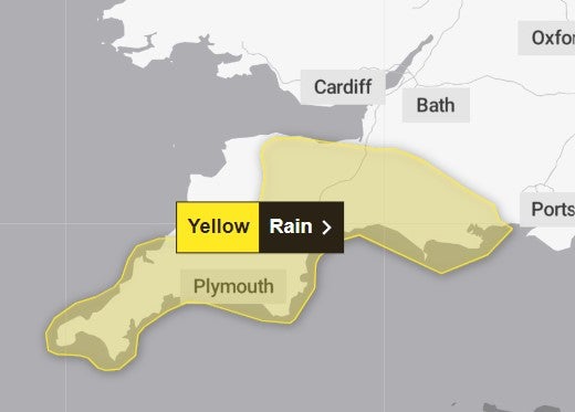
There are two warnings in place, as rainfall in the southwest began early on Sunday morning and is expected to last until midnight.
“Rain will move east across southwest England on Sunday morning, persisting through much of the day before slowly easing later,” the Met Office said.
“15 to 25 mm of rainfall is expected quite widely with 40-60 mm over Dartmoor and Exmoor. There is a small chance of these higher accumulations falling in some lower lying parts of Devon and Cornwall too.”
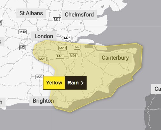
The warning for the southeast begins at 3pm today and is in place until 9am Monday.
The warning says: “Rain is expected to arrive across Sussex and Kent during Sunday afternoon, persisting through the night before slowly clearing on Monday morning.”
Mr Dewhurst added: “We are keeping an eye on this area of low pressure as it moves into southern counties of England and Wales over the course of Sunday and into Monday.
“It will bring some heavy rain and some strong winds as well. This rain is falling on saturated ground and could lead to some localised flooding problems.”
Met Office meteorologist Greg Dewhurst, urged people to “take care if you are travelling through the day on Sunday across southern counties”.
The Environment Agency has issued 59 flood warnings, where flooding is expected, and 164 flood alerts, where flooding is possible, across England.
Where flooding occurs, there is a chance of delays to transport services, the Met Office added.
Sunday’s temperatures are set to reach around 7C-9C and there should be generally light winds, “but stuck under some cloud and with showers passing through it will feel chillier than the numbers suggest”, particularly across southern areas where double figures are expected, Mr Dewhurst added.
Rainfall led to the closure of several schools in Herefordshire and Worcestershire on Thursday because of rising flood levels and “treacherous road conditions”, councils said.
Many roads across the West Midlands in particular were submerged and rail operators struggled to resolve issues on the tracks, with Transport for Wales and West Midlands Railway services operating a replacement bus service between Shrewsbury and Wolverhampton.
Five-day forecast
Tonight:
Rain in the south gradually clearing most, though lingering in the far southeast. Mostly dry elsewhere with some coastal showers. Turning chilly with a patchy frost mainly in the north.
Monday:
Largely dry with sunny spells and a few showers, these mostly in the northeast. Rain and stronger winds in the southeast slowly easing through the day. Temperatures around average.
Outlook for Tuesday to Thursday:
Rain spreading southeast on Tuesday, then brighter with showers in the north. Dry start on Wednesday with further rain arriving from the west, turning heavy at times through Thursday.
Join our commenting forum
Join thought-provoking conversations, follow other Independent readers and see their replies
Comments
Bookmark popover
Removed from bookmarks