Hottest day of the year recorded as temperatures in the UK hit 34C
Temperatures in the capital almost reached 35C on Tuesday, as the Met Office reported record-breaking heat in June
The UK has recorded its hottest day of the year so far as temperatures surpassed 34C and much of the country swelters in heatwave conditions.
A high of 34.7C was recorded in St James’s Park in central London on Tuesday afternoon by the Met Office, beating the previous warmest day of the year on 21 June, where a scorching 33.2C was recorded in Charlwood, Surrey.
Much of England has faced warnings of extreme heat this week as Monday brought the hottest start to Wimbledon on record and temperatures shot up to maximums of 33.1C in Heathrow and 32.9C in Kew Gardens.
The previous warmest opening day on record was on 25 June 2001, when temperatures hit 29.3C.
Met Office spokesperson Stephen Dixon said that Tuesday would likely mark “the peak of this current heatwave in terms of absolute temperatures we’re expecting”.
“It’s a continuation of recent days in the South East in particular, with those temperatures well beyond average for the time of year, in a fairly notable heatwave,” he added.
Not only has July started with the hottest day of the year so far, but the Met Office released reports of a record-breaking June. England had its warmest June on record, per the forecaster’s provisional statistics.
The UK experienced its second warmest June since the series began in 1884, with a mean temperature of 15.2C for June, only surpassed by June 2023, which recorded 15.8C.
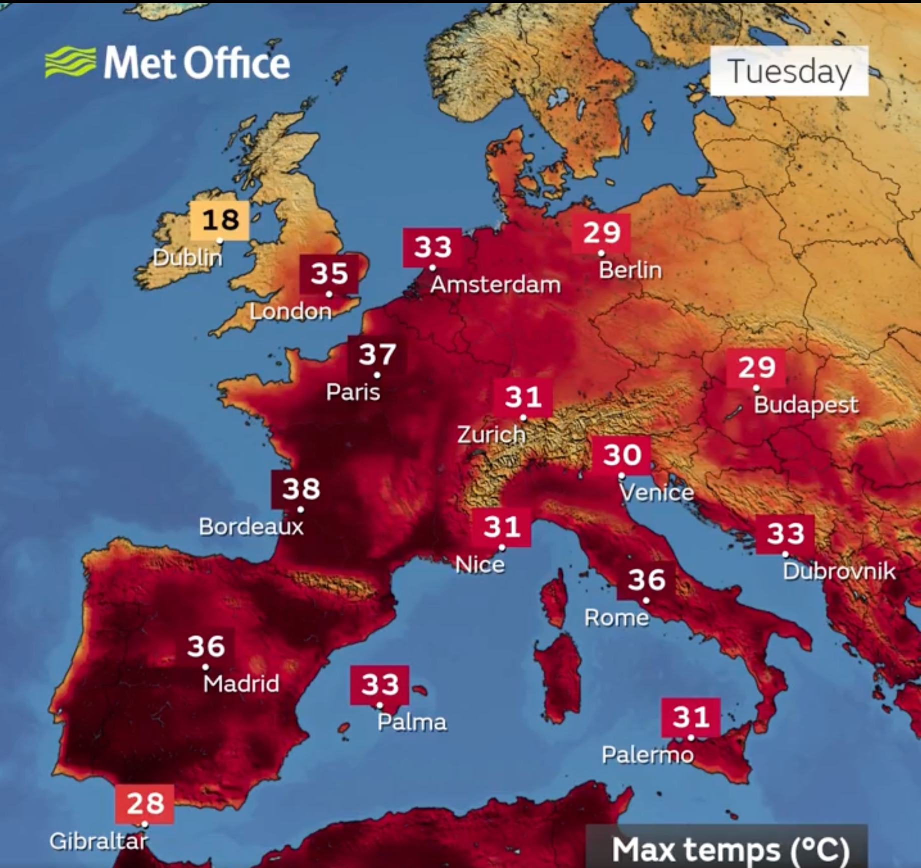
It is the second heatwave for parts of the UK within the last month, as Europe more widely is facing searing temperatures in the high thirties with wildfires across Turkey and Greece.
Met Office climate scientist, Dr Amy Doherty, said: “While we’ve not conducted formal climate attribution studies into June 2025’s two heatwaves, past studies have shown it is virtually certain that human influence has increased the occurrence and intensity of extreme heat events such as this.
“Numerous climate attribution studies have shown that human influence increased the chance that specific extreme heat events would occur, such as the summer of 2018 and July 2022. Our Met Office climate projections indicate that hot spells will become more frequent in our future climate, particularly over the southeast of the UK. Temperatures are projected to rise in all seasons, but the heat would be most intense in summer.”
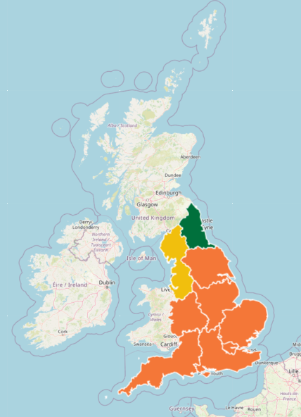
The UK Health Security Agency (UKHSA) also extended amber heat health alerts covering London, the East Midlands, South East, South West, Yorkshire and Humber, the West Midlands and East of England, until 9am on Wednesday.
Alerts provide a warning system to authorities and the public to show when temperatures may hit dangerous levels, impacting health and social care services. They are colour coded from green (no alert), yellow, amber, to red (emergency response).
A yellow alert indicates that weather conditions may affect vulnerable people, while an amber alert warns that conditions could impact the wider population, putting pressure on health services.
A heatwave is declared when areas reach a certain temperature for three consecutive days, with thresholds varying from 25C to 28C in different parts of the UK.
It seems that Tuesday will be the peak of the heatwave, as temperatures are set to drastically descend to the low twenties, with balmy peaks of 21-23C in the south of England. A cooler, wetter front over Scotland and the north of England will gradually move southeastwards.
“It’s already bringing some rain to parts of Scotland through the day today, and will gradually move southwards through the day today and overnight tonight,” Mr Dixon said.
“Tomorrow will be feeling fresher for many, with temperatures more likely to kind of get into the mid-20s, and some showery rain, particularly in some eastern coasts, through the day tomorrow as well.”
Forecasters say conditions will stay relatively dry throughout the week in the South, with the weekend looking more unsettled, with frequent showers, particularly in western areas.
While showers are expected to eventually move towards the south of England, people have been warned to watch out for wildfires amid the dry and hot conditions.
Ben McCarthy, head of nature conservation and restoration ecology at the National Trust, said: “With record-breaking temperatures across the country this week following the driest spring on record, our ranger and countryside teams are on high alert for fires which can cause decades of damage to habitats, decimate ecosystems and result in significant losses to our wildlife.
“Unfortunately, the sad truth is that most of the fires in the UK that impact our landscapes are started by people, whether accidentally or not, rather than by natural causes.
“Therefore, we’re calling on people to help us protect wildlife and habitats by acting responsibly when outdoors, as even a small spark can cause a fire, and to please call 999 if you see a fire or any suspicious behaviour.”
Join our commenting forum
Join thought-provoking conversations, follow other Independent readers and see their replies
Comments
Bookmark popover
Removed from bookmarks