Summer 2020 Arctic wildfires break carbon emissions records
The EU’s monitoring service revealed that carbon emissions from the Arctic Circle fires so far this year are already up one-third compared to the whole of 2019, writes Louise Boyle

The summer of wildfires in the Arctic Circle has broken last year’s carbon emissions record, according to the European Union’s earth observation programme, as the region continues to deteriorate at a faster pace than the rest of the world.
Carbon dioxide (CO2) emissions from Arctic Circle fires were up by more than a third in 2020 compared to last year, according to new data published Thursday by the Copernicus Atmosphere Monitoring Service (CAMS) at the EU’s medium-range weather forecasting centre (ECMWF).
Scientists have estimated that between 1 January-31 August this year, CO2 emissions for the region were 244 megatonnes (Mt) – compared to 181Mt for the whole of 2019.
Carbon emissions are accelerating the climate crisis and having severe impacts on polar regions. The Arctic has already warmed at least twice as fast as the rest of the planet in the past 30 years.
“The Arctic fires burning since middle of June with high activity have already beaten 2019’s record in terms of scale and intensity as reflected in the estimated CO2 emissions,” said Mark Parrington, senior scientist at CAMS.
“Our monitoring is vital in understanding how the scale and intensity of these wildfire events have an impact on the atmosphere in terms of air pollution.”
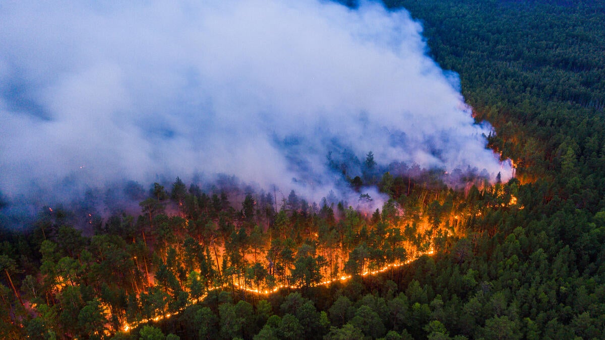
The blazes have ripped through millions of acres in Russia’s Sakha Republic which straddles the Arctic Circle. Satellite images have captured huge plumes of smoke spreading over an area that is a third the size of Canada.
In the vast region, spanning 1.19 million sq miles (3m sq km) there has been a large spike in CO2 emissions from 208Mt in 2019, to 395Mt this year.
In June the town of Verkhoyansk, Sakha, reported what is believed to be the highest temperature – 38C (100.4F) – ever known inside the Arctic Circle.
Arctic fire season typically peaks in July and early August but forecasters noted that Sakha, and the neighbouring Chukotka region, were still suffering above average wildfires on a daily basis last month.
Researchers are unclear what sparked the massive wildfires. However some blazes early in the season were so-called “zombie fires”, a phenomenon where peat fires smoulder underground during winter and reappear in the spring.
Fires have largely burned unabated as the region is largely inaccessible and sparsely populated. The blazes are fuelled by the boreal forest, which wraps around the top of the northern hemisphere, peat bogs and tundra, which produce more smoke than trees or grass when they catch fire. Boreal forest, peat bogs and tundra all have higher concentrations of carbon which spew CO2 into the atmosphere when burned.
In the past three months, across the Eastern Federal District of Russia, the country’s largest but least populated districted, wildfires pumped out approximately 540Mt of carbon emissions, blowing past the previous highest total emissions in that region in 2003.
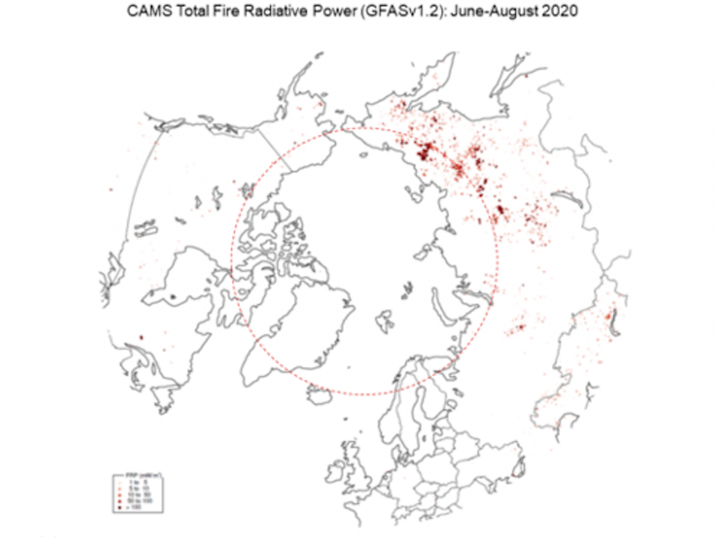
To gather the data, the EU forecasting service uses a ”Global Fire Assimilation System (GFAS)” which pulls observations on fire radiative power from satellite sensors to produce daily estimates of emissions from wildfires and biomass burning around the world.
In California, fire crews have been battling the second and third worst fires in state history. The latest satellite data showed large plumes of smoke moving eastward across the Great Lakes towards the North Atlantic.
The intense and widespread wildfires, which have also affected Colorado, are believed to have been started by lightning strikes and exacerbated by dry and extremely hot conditions.
GFAS also showed that in Colorado, the intensity for the whole state has been well above the 2003-2019 average for most of August, while in California, the intensity peaked in the second half of the month.
Carlo Buontempo, director of the Copernicus Climate Change Service (C3S), said in July that while the Arctic Circle has large fluctuations from year to year, what is concerning is how fast the region is warming.
In 2019, the UN’s Intergovernmental Panel on Climate Change found that the cryosphere – the places on the planet which regularly turn to snow or ice – was melting at an unprecedented rate.
Sea ice loss from the polar regions has the potential to impact global weather patterns, leading to greater unpredictability in the systems. The melting of polar glaciers and ice sheets are the greatest drivers of global sea level rise which is now more than twice as fast as in the 20th century.
Arctic melting is caught in a ruinous feedback loop: As the region’s permafrost thaws out, it will likely pump billions of tons of greenhouse gases into the atmosphere, driving global heating, and only accelerating towards climate breakdown.
Join our commenting forum
Join thought-provoking conversations, follow other Independent readers and see their replies
Comments
Bookmark popover
Removed from bookmarks