Flood map reveals which areas are most at risk from climate change
Some areas are at risk even if climate pledges are met and temperature rise kept to 1.8C
A map has revealed the areas in the UK most at risk of flooding damage over the next century as climate change worsens.
Researchers have compiled a detailed map showing the expected annual damage (EAD) in towns and cities across the country.
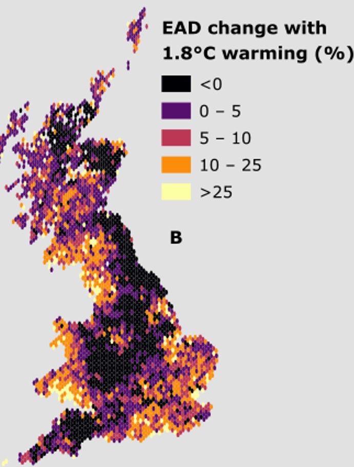
They say the damage could increase by more than a fifth from today’s terms but could be reduced or avoided altogether if pledges to reduce emissions are met.
Some areas are more at risk from climate change than others and there are “hotspots” where homes and businesses at particularly in danger.
Map A represents historical flood damage from 1960 to the present day and Map B represents forecast damage over the next century.
Areas that are coloured lightly are forecast to be more damaged. For example, London is forecast to be worse off than places in the north of Scotland.
Each dot on the map represents an area of 10km. The figures in the key in both maps are in thousands.
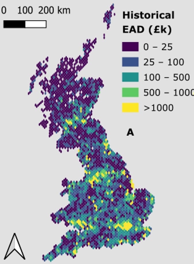
The maps, produced by the University of Bristol and Fathom, a global water risk modelling company, predict that parts of London, Cardiff, Manchester and Edinburgh could suffer the most financial damage because of flooding.
And even if climate change pledges are met and temperature increases are kept to around 1.8C, areas such as South East England, North West England and South Wales are still set to experience significantly increased flooding.
The detail in the new "flood risk map" also reveals locations that will be largely unaffected, which researchers say will be key for future planning decisions. The model indicates flood hazards in northeast and central England as well as eastern and northern Scotland changed very little from the present day.
Lead author Paul Bates, professor of Hydrology at the University of Bristol and Chairman of Fathom, said: “For the first time this flood model gives us a more accurate and detailed picture of the impact of climate change on the risk of flooding in the future across the UK.
“The results are a timely warning to the country’s political leaders and business sector that global commitments to significantly reduce carbon emissions must be taken very seriously, and ultimately take effect, in order to mitigate increased losses due to flooding.”


“Although the most optimistic climate scenarios see only modest increases in flood losses at a national level, these new data demonstrate how this conceals dramatic variations across the country, with some places seeing large changes and others very little,” Mr Bates added.
“This is a result of changing patterns of future rainfall, river flow and sea level rise, and this leads to the regional differences we predict.
“We found that flooding increases most in places where risk is already high now, so the best thing we can do to prepare for the impact of climate change is to strengthen flood management in currently at-risk areas, and this will bring immediate economic and social benefits as well."
For their study, the researchers simulated different types of flooding in the coming decades, including information about terrain, river flow, rainfall patterns and sea level to build a detailed picture of how much damage floods could cause to homes and businesses.
This was combined with Met Office climate predictions over the next century and the team said it was modelling flooding in Northern Ireland to produce a UK-wide picture in the future.
Dr Oliver Wing, chief research officer at Fathom, said it was vital to pinpoint the areas in the UK that are most at risk from flooding.
"Our model shows that there are many places where flood risk is growing," he said.
"Being able to understand the communities where this is likely to happen allows us to make sensible investment decisions - about flood defence structures, natural flood management or even moving people out of harm’s way."
Join our commenting forum
Join thought-provoking conversations, follow other Independent readers and see their replies
Comments
Bookmark popover
Removed from bookmarks