Typhoon Mawar inches closer to Japan threatening to bring heavy rains and winds
Mawar, despite weakening, threatens to lash Okinawa with heavy winds and rains
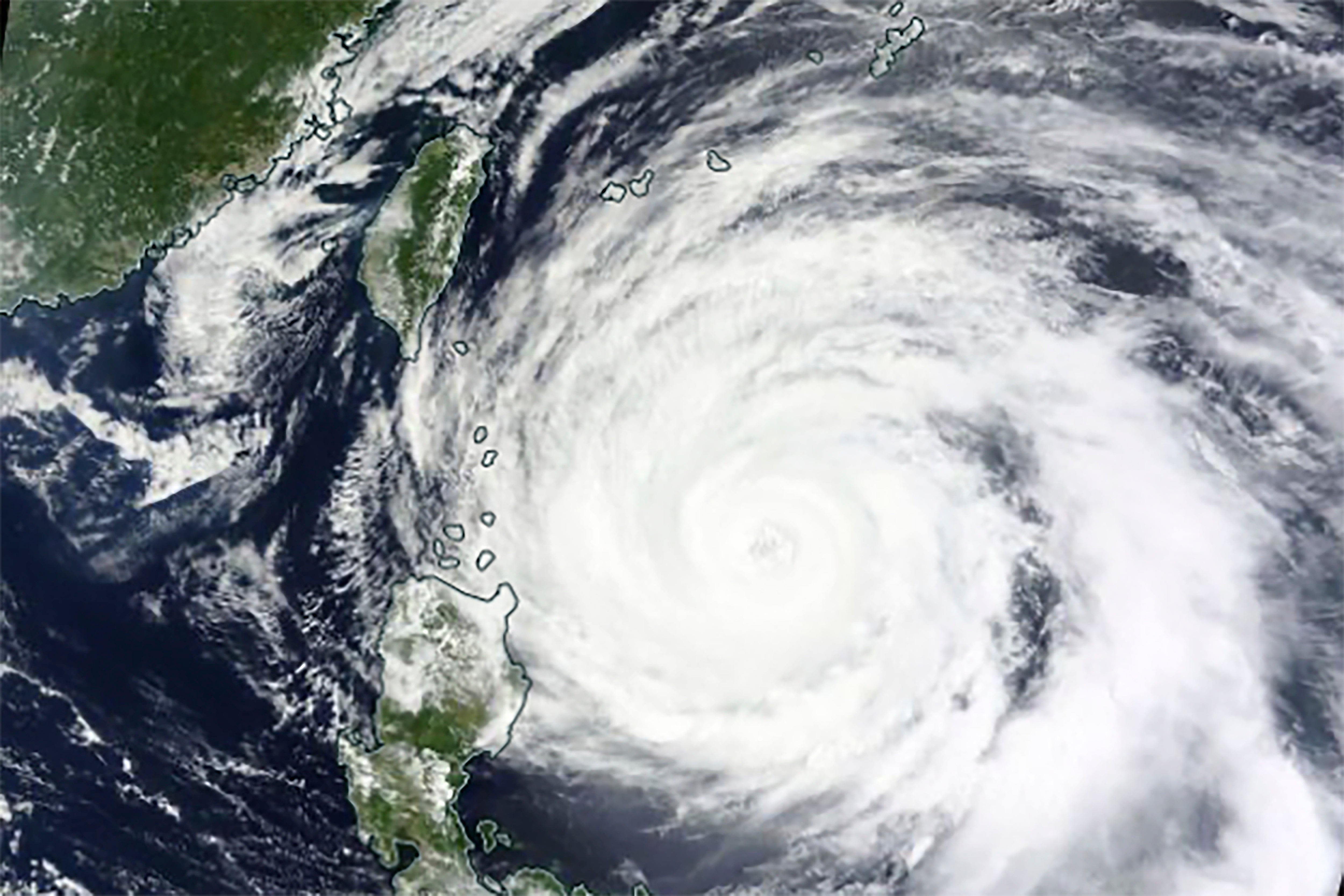
Typhoon Mawar, also known as typhoon Betty, is moving slowly towards southern Japan, threatening to lash Okinawa with heavy rains and winds after passing over the Philippines.
The Sakishima Islands of Okinawa are currently experiencing strong winds, which were expected to intensify as the typhoon drew closer, the state weather agency warned.
At Painushima Ishigaki Airport, a maximum wind speed of 87kmh was observed, while Hateruma Island recorded winds of 86kmh.
The typhoon was still in the Philippines Area of Responsibility, the oceanic area monitored by the weather agency of the archipelago, but was inching closer to Okinawa and away from the northern islands.
It was moving northward with maximum sustained winds of up to 126kmh near its centre and gusts as strong as 180kmh. It had a central barometric pressure of 965 hectopascals, the Philippine Atmospheric, Geophysical and Astronomical Services Administration (PAGASA) said.


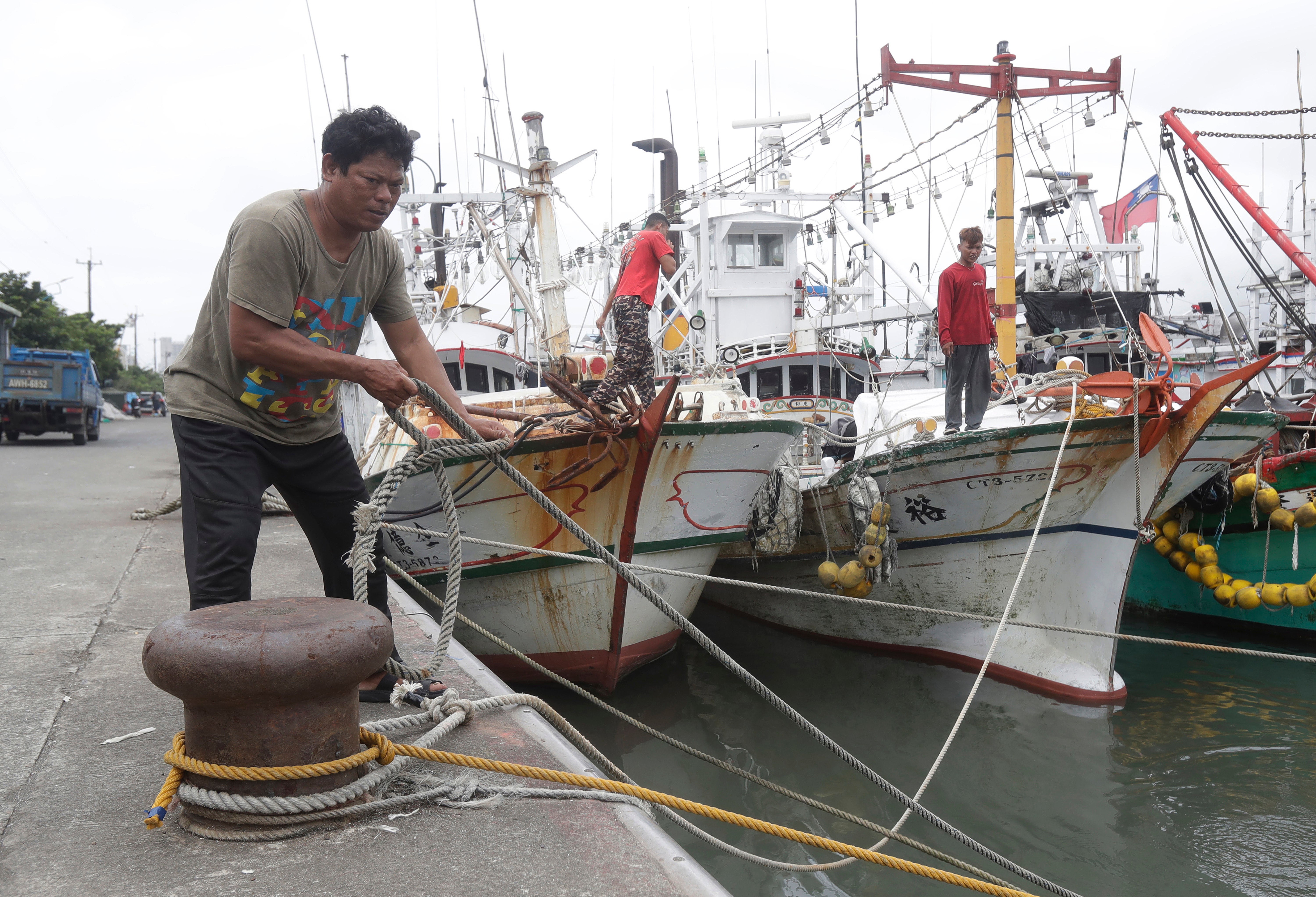
The typhoon also lashed the Taiwanese fishing town of Yilan with high tides and winds, as extreme weather warnings were issued for coastal communities. Fishermen secured their boats and homes against the stormy conditions on Tuesday evening and took shelter.
“The wind and waves are very strong,” coast guard officer Wang Hsing-chieh told the Associated Press.
“We hope that beachgoers won’t come near the beach and embankment at this moment. We will also send coast guard personnel to patrol the port to warn beachgoers.”
The Batanes islands and northern province of Luzon, the country’s most populated area, was under warnings for floodings, landslides and heavy winds. The storm spared the country, which is the most exposed one to tropical cyclones in the world, from a direct landfall and continued its trek northward.
More than 3,400 villagers remained in emergency shelters in northern provinces, flights to and from Batanes remained suspended, and classes have not resumed in more than 250 cities and towns in the north, according to the office of civil defence, AP reports.
Winds lashed nearby Cagayan province on Monday, causing an unoccupied wharf warehouse to collapse and prompting more villagers to move to evacuation centers.

Typhoon Betty, as it’s called in the Philippines, was forecasted to gradually accelerate on Wednesday and Thursday, moving generally northward over the waters east of Batanes Island, PAGASA said in its 11am update on Wednesday morning.
Although some wobbling in its movement, such as sudden turns to the north-northeast or north-northwest, was possible within the next 12 hours, the typhoon was expected to turn more northeastward by Thursday afternoon or evening.
It was projected to exit the PAR on Thursday evening or early Friday morning and potentially make landfall close to the central Ryukyu Islands of Japan, particularly Okinawa, by mid-Friday.
The Philippines' weather agency also mentioned that the typhoon, which was a super typhoon last week, was anticipated to steadily weaken over the next five days due to cooler ocean waters, dry air intrusion, and increasing vertical wind shear.
However, experts raised concerns in the past that it can stagnate in the region for a longer period.
There is a possibility that the typhoon may be downgraded into a severe tropical storm by Wednesday night or Thursday morning, PAGASA said, and further weaken into a tropical storm by Friday evening or Saturday morning.
However, the extent of dry air intrusion's impact on the typhoon may result in a faster weakening rate, it said.
The slow movement of the typhoon, along with its potential to affect Japan over an extended period, raised concerns about the potential damage. While slower-moving typhoons have a longer duration of impact, they can also cause more damage due to prolonged exposure to strong winds, heavy rainfall, and high waves.
The Western Pacific typhoon season stretches across the entire year, but most storms form between May and October. The region sees more tropical storms and typhoons each year than any other ocean basin.


Tropical cyclones are formed in the warm waters and are also becoming more frequent and intense, as well as slow-moving, leading to more damage due to the climate crisis, scientists have warned.
Last week, Mawar lashed the remote US territory of Guam and left the island with heavy damages, power cuts and flooding before rapidly intensifying to category-5 strength in the Philippine Sea, becoming the strongest typhoon in 2023 and the most intense recorded in May.
Join our commenting forum
Join thought-provoking conversations, follow other Independent readers and see their replies
Comments
Bookmark popover
Removed from bookmarks