Hand-held laser scanner creates 3D maps of crime scenes in minutes
The Zebedee scanner records 40,000 data points every second and will be used to help forensics teams as well as present evidence to juries

Sign up to our free weekly IndyTech newsletter delivered straight to your inbox
Sign up to our free IndyTech newsletter
A hand-held scanner that creates perfect 3D maps at a walking pace is set to revolutionize crime scene investigation.
The Zebedee scanner uses technology originally designed to explore cave complexes and has been developed by CSIRO, Australia’s national science research agency.
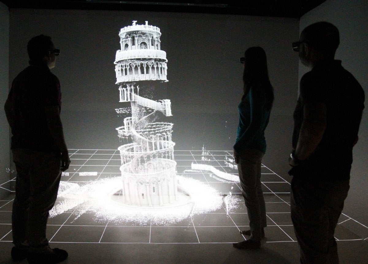
It’s previously been used to map the interior of the Leaning Tower of Pisa (above) but has now been issued to police in Queensland, who say it can map a crime scene in just 20 minutes.
"The benefits of this new technology will reduce interference at a scene, save time and allow access to previously hard to reach areas such as step declines and bushland," said Queensland Police Commissioner Ian Stewart.
Stewart said the device would save police “many thousands of hours in investigation” and would lead to “faster capture of accurate information in our investigation process”. The maps created by the Zebedee will also be used to illustrate crime scenes in court cases.
Each scanner costs $37,000 and although the police only the Australian police only currently have a single unit, they hoping to purchase one for each individual state.
Looking like a futuristic dowsing rod, the Zebedee is named after the moustachioed character from 70s children’s TV show The Magic Roundabout, who also rested on a spring.
Unusually, the spring itself is the key to the technology. The device at the end of the wand is a conventional 2D LIDAR scanner that bounces lasers beams off nearby objects (it has a range of 30 metres and creates about 40,000 measurements every second), counting the time it takes for these to return in order to measure the distance.
By fixing this scanner to the spring and setting it moving the scanner’s field of view is increased. Cleverly, even the disturbances created by the person walking with the device actually increase the field of view by allowing it to oscillate in “an irregular fashion”.
CSIRO say that the next step will be to use drones that allow the scanner to fly. They also hope that it will be used to map more cultural heritage sites like the Tower of Pisa.
"Our detailed record of the Leaning Tower of Pisa may one day be critical in being able to reconstruct the site if it was to suffer catastrophic damage,” said Franco Tecchia, Assistant Professor at the PERCRO - Perceptual Robotics lab.
"Having a detailed 3D model of the world's most significant cultural heritage sites could also be used to allow people who cannot physically visit these sites to better understand and appreciate their history and architecture.”
Subscribe to Independent Premium to bookmark this article
Want to bookmark your favourite articles and stories to read or reference later? Start your Independent Premium subscription today.
Join our commenting forum
Join thought-provoking conversations, follow other Independent readers and see their replies