‘Prolific snowmaker’ storm threatens 180 million Americans from Texas through New England as store shelves go empty
Experts say the ‘largest winter storm of the season’ could blanket a stretch from Albuquerque to Dallas to New York and Boston with as much as a foot or more predicted
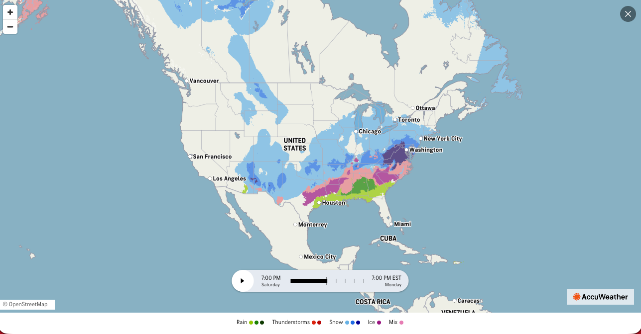
A panic-buying frenzy has swept across parts of the United States as forecasters warn a powerful winter storm will hammer 33 states across nearly 2,000 miles this weekend, bringing heavy snow and dangerous ice to more than 180 million people.
Pictures and videos shared on social media as early as Wednesday show grocery store aisles cleared of staples like milk, bread and bottled water as residents prepare for the storm’s expected impacts, particularly in states less accustomed to severe winter weather, including Alabama, Texas and Tennessee.
Dubbed Winter Storm Fern by The Weather Channel, forecasters predict it to bring a dangerous mix of heavy snow, sleet and damaging ice from the Southern Plains through the Midwest and up into the northeast.
Forecasters say the system could impact well over 180 million Americans with snow or ice as it moves from Texas and New Mexico toward New England.
The storm is set to start taking shape Friday in the Rockies and Plains before moving south into Texas and up into the Northeast, AccuWeather meteorologist Brandon Buckingham told The Independent on Wednesday.
.png)
“This may end up being the largest winter storm of the season,” Buckingham said. “This will undoubtedly rank up there in terms of highest impact storms this season.”
National Weather Service winter storm watches and warnings are already in effect across several regions from the southern Rockies through parts of the southeast and into the Ohio Valley and Northeast, as the storm’s timing and track become clearer.
Major cities, including Dallas, Oklahoma City, Nashville, Charlotte, Washington, D.C., Philadelphia and New York City, are among those in the projected path.
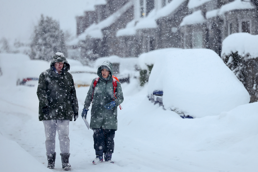
The storm is expected to develop by Friday, with snow, sleet and freezing rain increasing across the Plains and spreading eastward throughout the weekend. In southern states, forecasters warn of significant ice accumulations that could make roads impassable and bring down tree limbs and power lines, potentially leading to widespread outages.
Farther north, the heavy snow threat is strongest from New Mexico and the Texas Panhandle through the Midwest and into the northeast, where many areas could see at least six inches of snow, and in some cases, a foot or more.
Travel disruptions, including flight delays and cancellations, are expected at major hubs as snow and ice peak over the weekend.
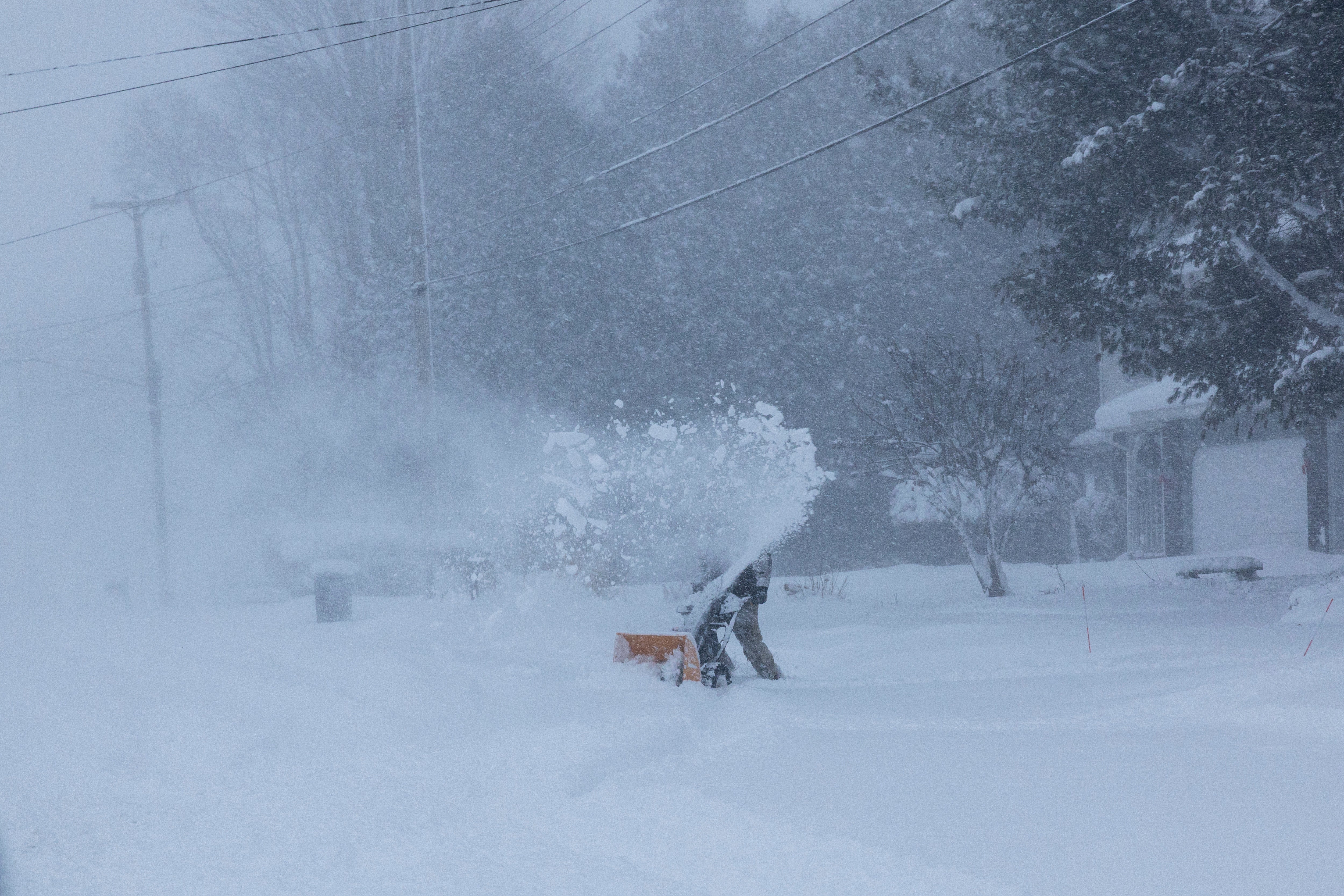
As the storm departs early next week, colder Arctic air will follow, keeping temperatures well below seasonal norms and posing additional risks of ice formation on untreated surfaces.
The deep freeze in a number of states could also take out trees, power lines and burst pipes. With below-freezing temperatures set to last through much of next week, removing the ice and fixing power outages may take time, and forecasters urge people to take precautions and prepare ahead of time.
Here’s what each region across the U.S. can expect.
The Rocky Mountains, the Great Plains and the South
Snow and ice are forecast in a stretch from the Rocky Mountains to the Great Plains, building a corridor of icy conditions before heading south toward Texas.
“This is a moisture-packed storm that’s going to be colliding with arctic air that’s off to the north of it,” Buckingham said. “As that occurs, a wide swath of snow and ice are expected to sweep across the central U.S., the Plains, into the Mississippi River Valley and into portions of the south and mid-south during the day Saturday.”
Accumulating snow will hit drought-affected states, including Wyoming, Colorado and New Mexico, while lesser snow may be seen in Utah and Arizona. Accuweather snow predictions range from 1-3 inches to as much as a foot in Albuquerque, New Mexico.
Cities including Denver, Wichita, Oklahoma City and Tulsa will likely see snow, sleet and freezing rain Friday. Oklahoma City is in the band that could see 6-12 inches.
“That will be a corridor of those icy conditions that we will be monitoring very closely as that develops,” Buckingham said.
Heading into Saturday, the storm is expected to worsen, bringing heavy snow and ice along the Interstate 40 corridor, from New Mexico to the Carolinas. Parts of Texas are expected to see 3-6 inches of snow.
A threatening ice storm may also impact residents from Texas all the way to the Carolinas.
Meanwhile, temperatures are expected to be bone-chilling, with forecasts showing temperatures will be below 32 degrees Fahrenheit for 48 to 60 consecutive hours in Dallas, Texas.
The Southeast
Snow and ice are expected to extend into the Southeast portion of the country on Saturday, hitting parts of Arkansas, Louisiana, Mississippi, Tennessee and Alabama.
“Pointing north of those locations, where it falls is all snow,” Buckingham said.
“It will be a prolific snowmaker for many areas that are used to dealing with snow, but snow of this magnitude, many of these areas don’t quite have the same resources as areas farther North,” he added.
Areas along Interstate 44 from Tulsa, Oklahoma, to just south of St. Louis, Missouri, may see some of the heaviest snow, according to Buckingham.
“That corridor of heaviest snow is supposed to be right just north of that transition line where that icy mix and the pure snow line kind of reside,” Buckingham said.
As the storm moves up the coast Saturday, places like Atlanta, the southern Appalachians and the Blue Ridge Mountains may see significant ice storms.
“Then you work your way into the Carolinas,” Buckingham said. “Northeast and Central South Carolina, a place like Charlotte or even Raleigh, for the latter half of the weekend, will be dealing with potentially significant icing concerns.”
Further north, in areas where the air is colder, like the Ohio River Valley, the central Appalachians, the Virginias, Maryland and southern Pennsylvania, can expect to see “snow expand and increase in intensity,” Saturday going into Sunday, Buckingham said.
The storm will likely bring all snow from the Ohio Valley to the Northeast.
“I think there could very well be a solid swath of 12 plus inches of snow that occurs from the storm system,” Buckingham said.
Northeast
As the snow piles up across much of the country, the storm will head northeast into Sunday.
The corridor of snow is expected to advance northward up the Interstate 95 corridor, potentially bringing snow to Washington, D.C., Philadelphia, New York City and Boston.

“Places like New York City, a majority of Pennsylvania and southern New England are expected to see those conditions rapidly deteriorate as snow falls in those areas,” Buckingham said.
New York could see 6-12 inches of snow, per Accuweather and Washington, D.C., is in the same prediction band as of now.
Forecasters remain uncertain when exactly the storm will ease up.
“Sunday night into Monday, there are still some question marks as to what the final act of this storm will be as it exits off the Atlantic Coast,” Buckingham said, noting some areas in the northeast may even see snow into Monday.
Join our commenting forum
Join thought-provoking conversations, follow other Independent readers and see their replies
Comments
Bookmark popover
Removed from bookmarks