Tornado warning issued as galeforce winds and snow to hammer UK ahead of New Year’s Eve
The Tornado and Storm Research Organisation is warning of ‘isolated tornados’ as Storm Henk threatens to hit the UK
A tornado warning has been issued for a large region of the UK as the country faces more severe weather in the wake of Storm Gerrit.
Winds will reach speeds of 70mph with a risk of isolated tornados in Wales, the Midlands, East Anglia, southern England and the Channel Islands, says the Tornado and Storm Research Organisation.
Its warning for the severe weather is active until Sunday morning at 6am.
The severe weather could be named Storm Henk - the next name for the storm recorded by the Met Office - and it follows Storm Gerritt which resulted in a tornado in Greater Manchester causing severe damage earlier this week.
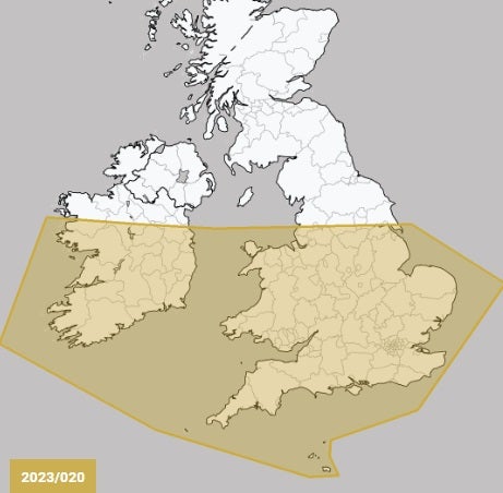

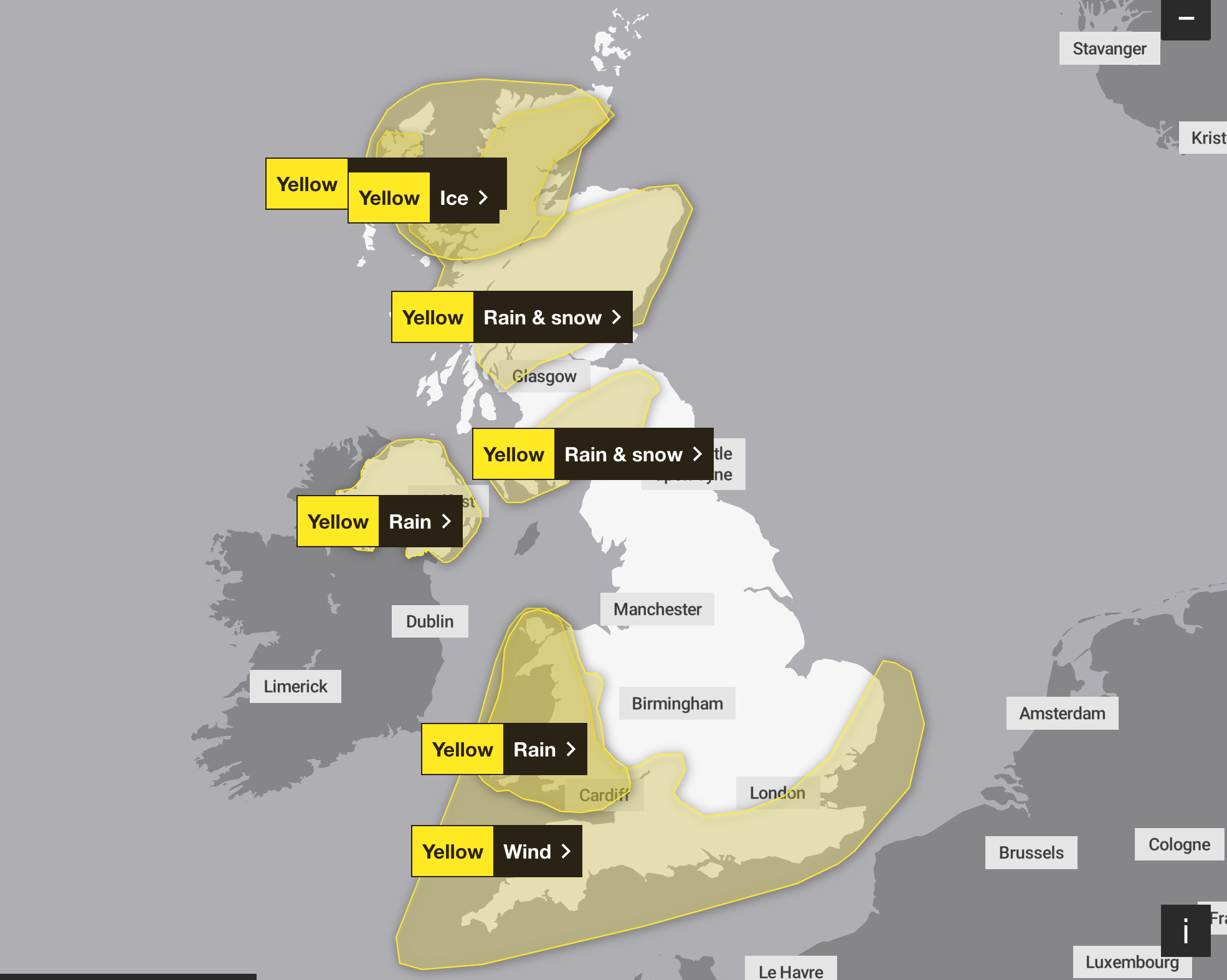
The warning comes as large areas of Scotland are facing a yellow warning from the Met Office for rain and snow which will last until midnight. A large part of Wales has been issued a warning for rain, while a warning over strong winds for southern England is in place until 3am tomorrow.
In its warning, the Tornado and Storm Research Organisation said: “The tornado risk, although low, may take on a bi-modal distribution - with one area of slightly higher risk being across the Republic of Ireland on Saturday morning, and the second being across parts of Cent Southern England, South East England, the South East Midlands, and East Anglia on Saturday night.
“This latter area will be monitored on Saturday for a possible tornado watch.”
The analysis from the organisation also warns of lightning, hail and winds of between 60mph and 70mph. The group is a 40-year-old private research body specialising in the prediction of extreme weather.
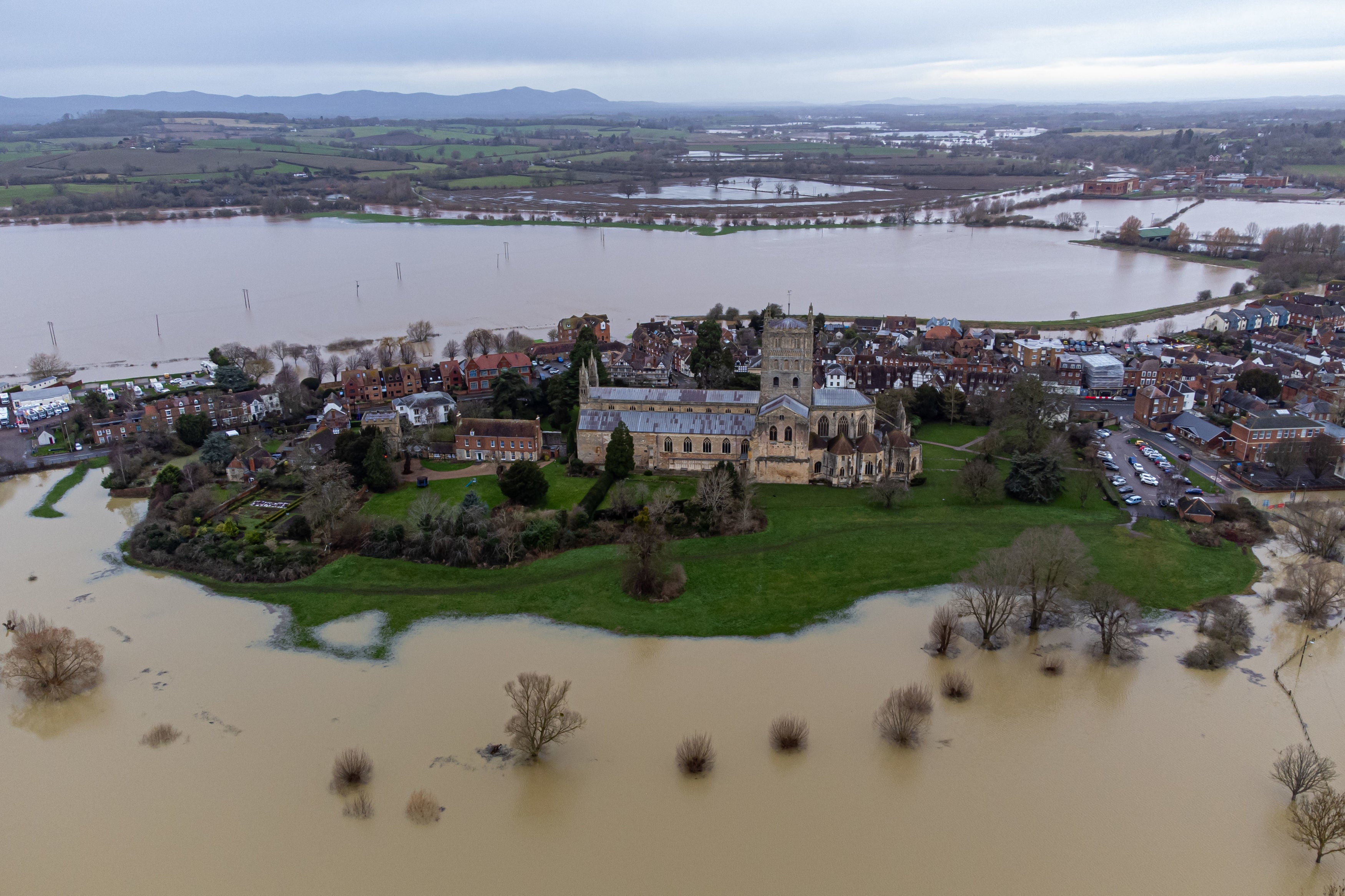
The weather conditions today have already brough disruption. Eurostar axed all its remaining trains on Saturday due to flooding in the tunnels between St Pancras International and Ebbsfleet, bringing misery to families planning trips to Paris.
Meanwhile, strong winds across southern England are causing hazardous driving conditions on the roads with a risk of a loss of power, according to the Met Office, which introduced a warning for the area at 11am today.
In Wales, the body warns rain could lead to flooding and transport disruption, while in Scotland, a “period of sleet and snow” will bring disruption.
Join our commenting forum
Join thought-provoking conversations, follow other Independent readers and see their replies
Comments
Bookmark popover
Removed from bookmarks