Which parts of the US can expect a white Christmas this year – and which will need to brace for storms, flooding and travel chaos
Deadly flooding is set to continue as record warmth heats up Christmas for millions of Americans
The chances of a white Christmas this year are slim for many Americans – but weather could play a more serious part in the festive season for millions.
Stormy weather is expected to impact travel across the U.S. as more than 120 million Americans heading home for the holidays take to the roads and skies.
While an atmospheric river storm in California resulted in deadly flash flooding, forecasters warned another was on its way.
Meteorologists also said an early-week clipper system is projected to bring snow and chilly temperatures from the Midwest to the Northeast.
"A somewhat larger clipper storm will affect parts of the Upper Midwest and Northeast from Monday to Tuesday," AccuWeather Senior Meteorologist Adam Douty explained.

Other parts of the country may experience dry but extremely warm weather this week, according to AccuWeather, with the potential to be one of the warmest Christmases on record in the south-central states.
"Close to two dozen states, from parts of the Rockies to portions of the Appalachians, northward through much of the Plains and part of the Midwest, are forecast to experience temperatures that are 15 to 30 degrees above the historical average by Christmas Day," AccuWeather Meteorologist Alyssa Glenny said.
The West
Travel is projected to be most disrupted in California and the West.
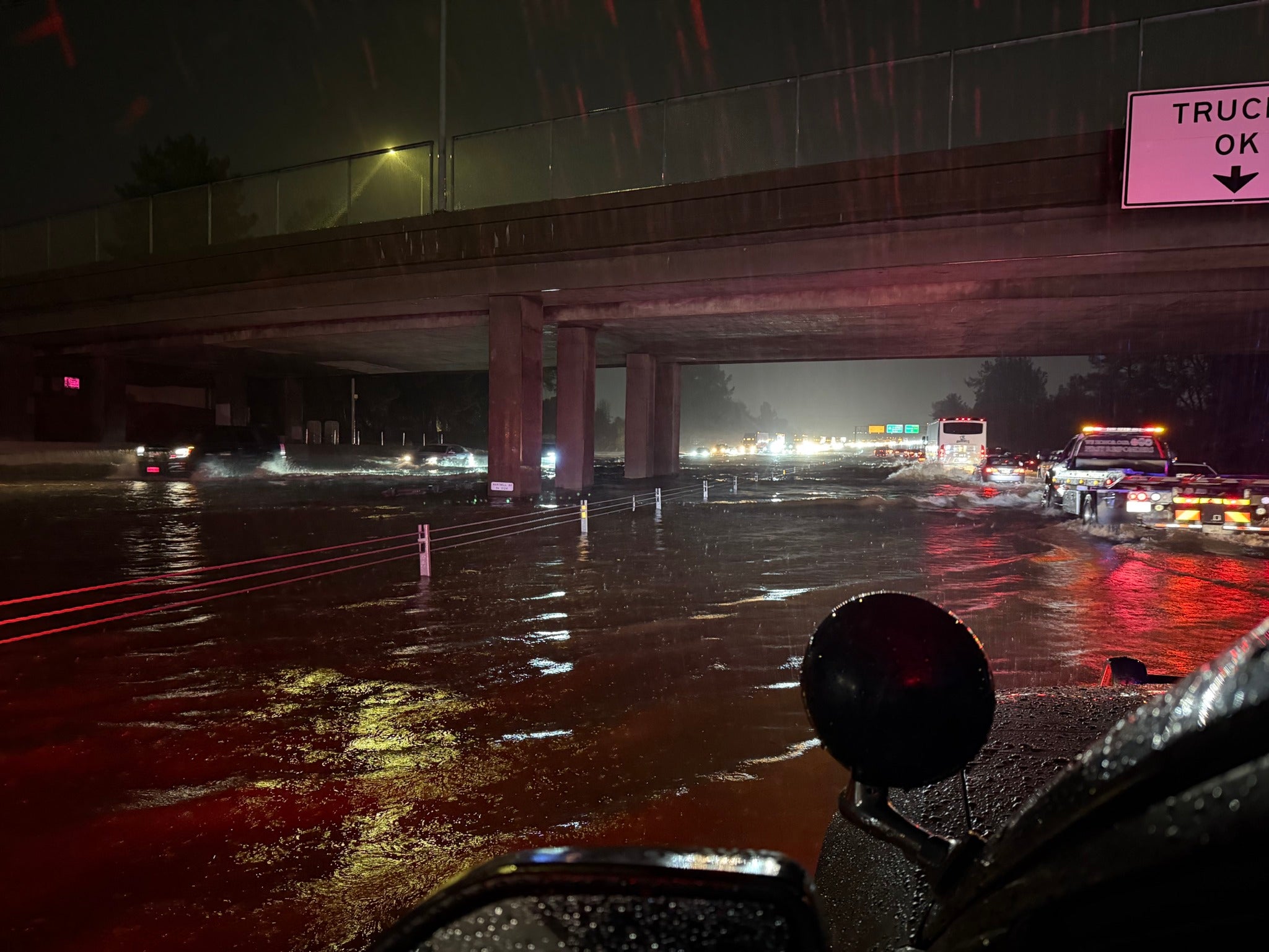
California, which has already seen nearly a foot of rain in some areas and hazardous flooding that resulted in the death of one unidentified person in Redding, is bracing for a second atmospheric river storm this week and more impacts to airports.
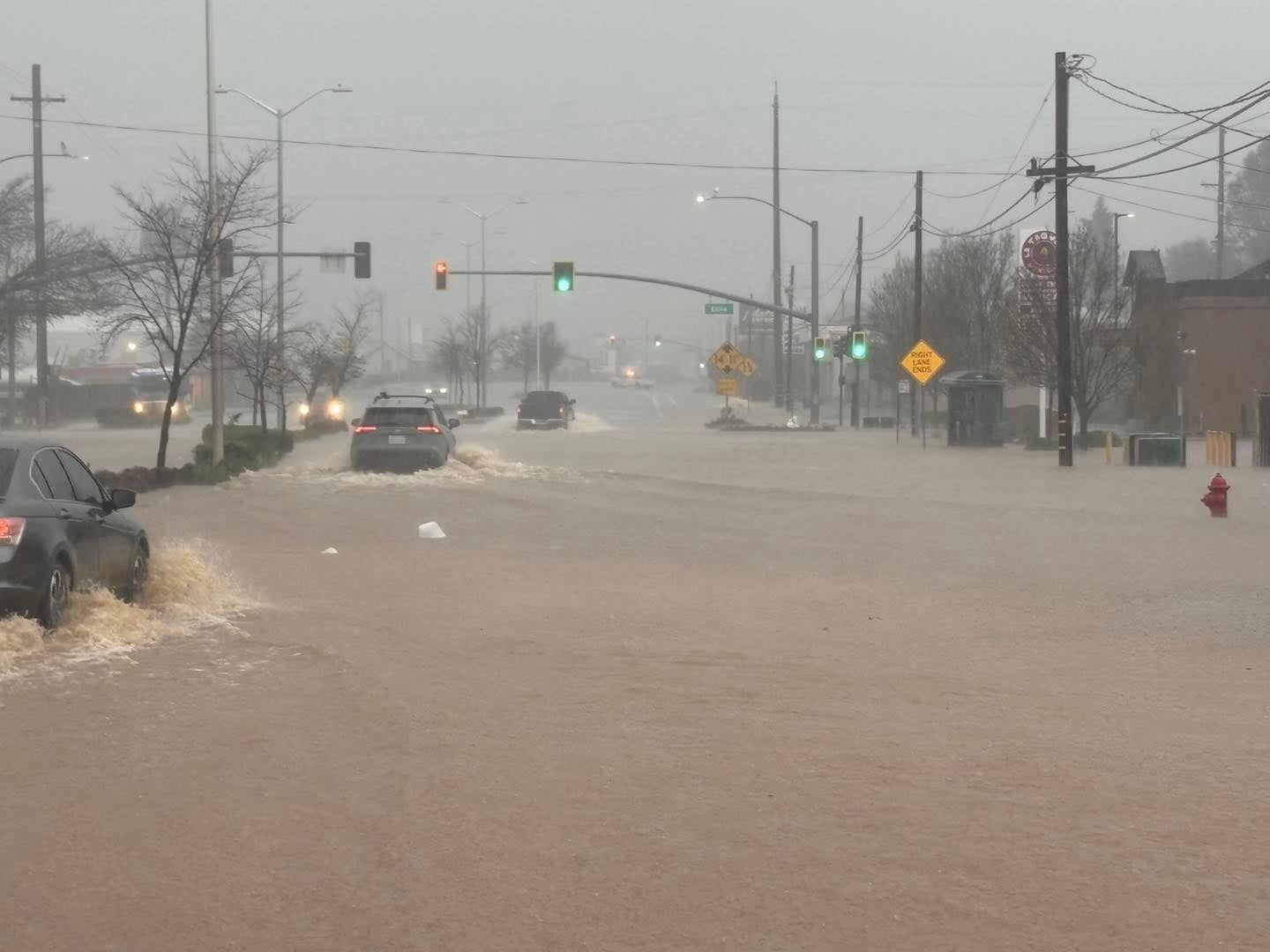
Flood warnings remained in effect in northern California’s Shasta County on Monday, as the National Weather Service cautioned that rivers, creeks, streams and other low-lying locations could flood.
“Please stay safe tonight and call in to report any emergencies or issues of concern so staff is aware,” Redding’s Mayor Mike Littau urged Sunday night on Facebook.
There’s “still more to come for the Redding area,” Katrina Hand, at the weather service's Sacramento branch, said.
Sacramento and the San Francisco Bay Area are set to see two or four more inches of rain, according to AccuWeather.
“Numerous flash flooding events are possible. In addition, many streams may flood, potentially affecting larger rivers,” the National Weather Service said. “The flooding may include debris flows in or near recently burned areas.”
Strong winds are another threat with this storm, said AccuWeather, including gusts up to 70 miles per hour in northern California.
While the first atmospheric river was largely focused on the northern and central regions of the Golden State, the second storm is anticipated to develop over central and southern California from Tuesday and past Christmas Day.
A flood watch is in place for Los Angeles starting Tuesday afternoon and lasting through Friday afternoon, with KABC reporting some communities could see up to 10 inches of rain.
With the storm, however, snow could finally fall around Lake Tahoe after one of the slowest starts to the season in decades.
Up the West Coast, snow was continuing to dump across Portland and up through the Seattle area.
“Models suggest up to 12 additional inches of snow is on the way above 4,000 to 5,000 feet by the time we get to Christmas Eve (Wednesday),” Portland’s KOIN said.
Meanwhile, critical fire weather conditions continued for a second week in windy Colorado, with above-normal temperatures slated to continue there through Christmas.
The Central and Southern states
In the central U.S. and southern U.S., the weather is forecast to be largely dry and warm this week.
That’s because of a large “bubble” of warm air building over the region, according to AccuWeather. The FOX Forecast Center said the air would challenge more than 100 record high temperatures in the regions.

Highs in much of Texas are in the 70s this week, with temperatures in Indiana, Nebraska and Arkansas in the 60s.
“Some record highs may be tied or broken at both official climate sites in Dallas-Fort Worth and Waco,” forecasters in Fort Worth, Texas, said in a social media post.
Christmas may break some records in the Lone Star State, Missouri, Oklahoma, Kansas and New Mexico, AccuWeather said.
Cool temperatures are forecast to return by next week in Oklahoma, Norman forecasters noted.
Along the Gulf Coast, Louisiana and Florida were also expected to see warm temperatures. Louisiana saw dense fog and Florida experienced winds over 30 miles per hour on Monday.
The Great Lakes to the East
A clipper system – a fast, low-pressure storm that forms in Canada – is bringing snow from the Great Lakes to New England and the Northeast early in the week before temperatures warm.
Detroit was set to see around half an inch before light rain starts on Monday afternoon.

Snow and a wintry mix is also set to impact travel in the northern mid-Atlantic and into New England.
In Boston, accumulating snowfall is likely on Tuesday, forecasters said, with up to three inches along and west of the I-95.
To the south, light snow was expected Monday night in New York City.
“Snow likely changes to rain along the coast Tuesday morning, and possibly by early afternoon for most inland areas,” the National Weather Service in the Big Apple said.
Tracker FlightAware showed there was some flight trouble at the city’s John F. Kennedy International Airport, as well as in Chicago and Atlanta.
Less than an inch of snow was projected to fall in Philadelphia, with precipitation shifting north.
Sadly for many, the chances of a white Christmas are slim below the northernmost reaches of the country.
"There is a chance a storm on Christmas Day brings some mix of snow and ice to parts of the interior Northeast," Douty noted. "But, with cold air being extremely limited, any fresh snow would likely be limited to the northern part of New York and New England."
“You know it’s bad when Florida has as much snow on the ground as South Dakota. This Christmas it appears the U.S. may have its lowest snow cover on record!” Florida meteorologist Jeff Berardelli said.
Join our commenting forum
Join thought-provoking conversations, follow other Independent readers and see their replies
Comments
Bookmark popover
Removed from bookmarks