DC to be hit with another snowstorm
‘Hazardous conditions could impact the Thursday evening commute and the Friday morning commute,’ National Weather Service says
Washington DC will be hit with heavy snowfall just days after a snowstorm brought the US Capital to a standstill.
Forecasts show that that between two and four inches could fall during Thursday night into Friday morning after more than a foot of snow fell in some areas earlier this week, with Huntington, Maryland southeast of DC reporting 15.5 inches of snow on Monday.
Hundreds of motorists were stuck on Interstate 95 in northern Virginia for more than 24 hours earlier this week as the storm caused dozens of accidents and brought traffic to a halt, trapping drivers, some with their families in tow, in their vehicles.
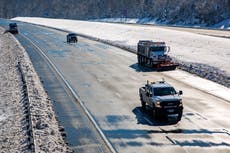
The DC region is still dealing with clogged, icy, and slippery streets from the storm on Monday as more snow is incoming on Thursday night.
A winter weather advisory is in effect for Washington, DC, Maryland, and northern Virginia from 9pm on Thursday until 5am on Friday.


The precipitation could begin as rain before transitioning to snow between 9pm and 10pm, with most of the snowfall likely to occur between 11pm and 5am. The snowfall could reach one inch per hour at times during the night, according to NBC Washington.
Up to six inches of snow could hit higher elevation areas, such as Shenandoah National Park about two hours southwest of DC.
The snowfall is expected to not be as heavy earlier in the week, but the speed with which it may fall could still pose problems for commuters.
The National Weather Service (NWS) in Baltimore, Maryland and Washington, DC said a winter storm warning was in effect from 3pm on Thursday until 10am Friday for Western Highland County in Virginia, Western Grant and Western Pendleton Counties in West Virginia, and for Garrett County in Maryland.
“Snow accumulations of 4 to 8 inches, with isolated totals up to 10 inches” are possible, NWS states on its site. “Northwest winds will increase and gust around 30 to 35 mph Friday morning. Wind chills around -10 to -15 degrees are possible along the ridge tops Friday morning.”
NWS adds that “travel could be very difficult. The hazardous conditions could impact the Thursday evening commute and the Friday morning commute”.
The service writes that “the heaviest snow is expected this evening with snowfall rates around one to two inches per hour possible” and they warn that “visibility will be reduced to below one-quarter mile at times in snow and blowing snow”.
“If you must travel, keep an extra flashlight, food, and water in your vehicle in case of an emergency. When venturing outside, watch your first few steps taken on steps, sidewalks, and driveways, which could be icy and slippery, increasing your risk of a fall and injury,” the service states.
Join our commenting forum
Join thought-provoking conversations, follow other Independent readers and see their replies
Comments
Bookmark popover
Removed from bookmarks