The Worst Storm in History? Hurricane Sandy looms over the East Coast, but just how bad could the 'Frankenstorm' be?

The latest headlines from our reporters across the US sent straight to your inbox each weekday
Your briefing on the latest headlines from across the US
Hurricane Sandy, or Frankenstorm, or indeed Superstorm Sandy - whatever you call it - this massive storm looks set on a course to wreak spectacular havoc across the US East Coast when it makes landfall sometime this evening.
But why, in particular, is this storm expected to cause such chaos, and are the American authorities over-hyping it?
Here are some reasons why forecasters, emergency services and residents are so worried about what Sandy might do:
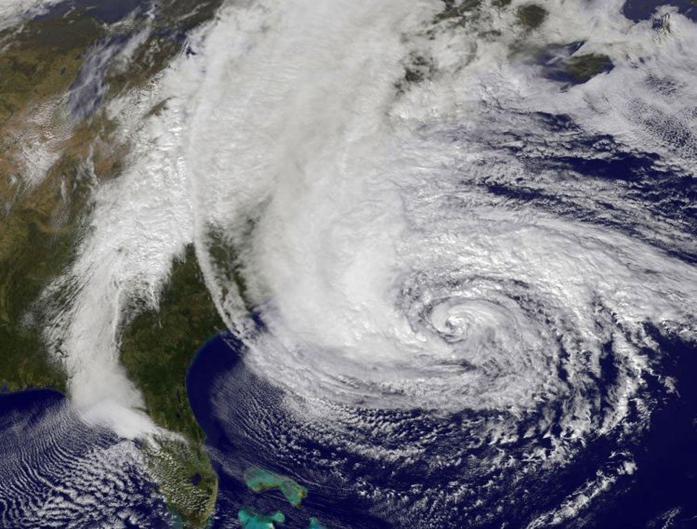
Hurricane Sandy is enormous.
Sandy is thought to be the second largest Atlantic tropical cyclone since 1988 - only bettered by Olga, a 2001 storm.
The storm has 175 miles of hurricane force winds stretching out from its centre, combined with tropical storm force winds extending 520 miles.
Because of its enormity the numbers of people who could be impacted by the storm is mind-boggling with somewhere in the region of 60 million Americans likely to experience some of the weather associated with Sandy - this is some 20% of the population of the US.
Its direction...
Normally hurricanes head off into the Atlantic as they move north.
This time Sandy is being forced by a high-pressure zone to head inland, where it will fuse with a cold front bearing down from Canada and could intensify.
This morning the storm appeared to be gaining in strength, recording winds of 85mph as it veered north.
The storm is expected to change direction later, moving towards the north-west, and putting the New Jersey coastline directly in its path.
The storm is predicted to pass possibly within 100 miles of New York.
The biggest storm in history?
Sandy has been compared to the Perfect Storm that slammed into the American northeast in 1991.
The National Oceanographic and Atmospheric Administration has also compared Hurricane Sandy to Hurricane Hazel in 1954 and the Great Gale of 1878.
The Great Gale of 1878 hit regions from New England to Cuba. Hurricane Hazel killed over a thousand people.
Hurricane Sandy could be particularly devastating because of the possibility it may merge with cold weather fronts from the west and north, creating a superstorm and meaning that as well as rain and high winds there could be up to two feet of snow in some areas.
Some experts say the storm could even be bigger than the 1938 New England hurricane known as the Long Island Express, which killed nearly 800 people.
Others have predicted it would be significantly more disastrous than last year's Hurricane Irene, which caused $15 billion in damage.
Storm surge of up to 12ft
Possibly the most worrying aspect of Hurricane Sandy is the forecast of a 12ft storm surge in the New York City area.
The highest ever storm surge in modern history at Battery Park was 10.5 feet in 1960.
Hurricane Irene saw a surge of just over four feet.
Officials have warned that the surge combined with rain means flooding would be “life-threatening.”
Experts from the hurricane centre have said the surges could reach 11 feet in New York Harbor, Long Island Sound and Raritan Bay in New Jersey.
High winds mean power cuts and damage
Hurricane strength winds are expected to do significant damage, causing power cuts across a huge area.
Ominously just after dawn this morning Sandy appeared to be gaining in strength, recording winds of up to 85mph.
Winds of 40-50mph are expected across a significant area across the East Coast.
It'll stick around...
The low pressure associated with this particular storm means it is likely to be long lasting.
Forecasters have predicted low pressure of 951 millibars, the lowest ever recorded in New Jersey was 961 millibars.
The tropical storm winds are unlikely to start to abate until well into Wednesday.
Up to 9 inches of rain.
Along with the high-winds, and the possible snow, some forecasters are suggesting there could be as much as nine inches of rain in some areas, leading to significant flooding.
Travel chaos
Hurricane Sandy has already been responsible for the grounding of flights across the US and from the UK.
Around 3,000 flights have been cancelled because of airports shutting down. Yesterday evening, in anticipation of the arrival of Sandy the New York transportation system closed at 7pm.
Subscribe to Independent Premium to bookmark this article
Want to bookmark your favourite articles and stories to read or reference later? Start your Independent Premium subscription today.
Join our commenting forum
Join thought-provoking conversations, follow other Independent readers and see their replies