From a cave of giant crystals in Mexico to the grass bridges of Peru: 6 world wonders you've never heard of
A new book lists our planet's oddest sights - here are our picks of the most amazing natural wonders you didn't know about
Inspiring equal parts wonder and wanderlust, new book Atlas Obscura celebrates over 600 of the most curious and unusual destinations around the globe.
More cabinet of curiosities than traditional guidebook, it revels in the unexpected, the overlooked, the bizarre, and the mysterious. Here, we’ve picked six entriesfrom Atlas Obscura that reveal our favourite little-known natural wonders (or, at least, wonders made from natural materials) around the world.
Peru: The Last Incan Grass Bridge
Huinchiri, Cusco
The Incas never invented the wheel, never figured out the arch, and never discovered iron, but they were masters of fibre. They built ships out of fibre (you can still find reed boats sailing on Lake Titicaca). They made armour out of fibre (pound for pound, it was stronger than the armour worn by the conquistadors). And their greatest weapon, the sling, was woven from fibres and powerful enough to split a steel sword. So when it came to solving a problem like how to get people, animals, and goods across the steep gorges of the Andes, it was only natural that they would turn to fibre.
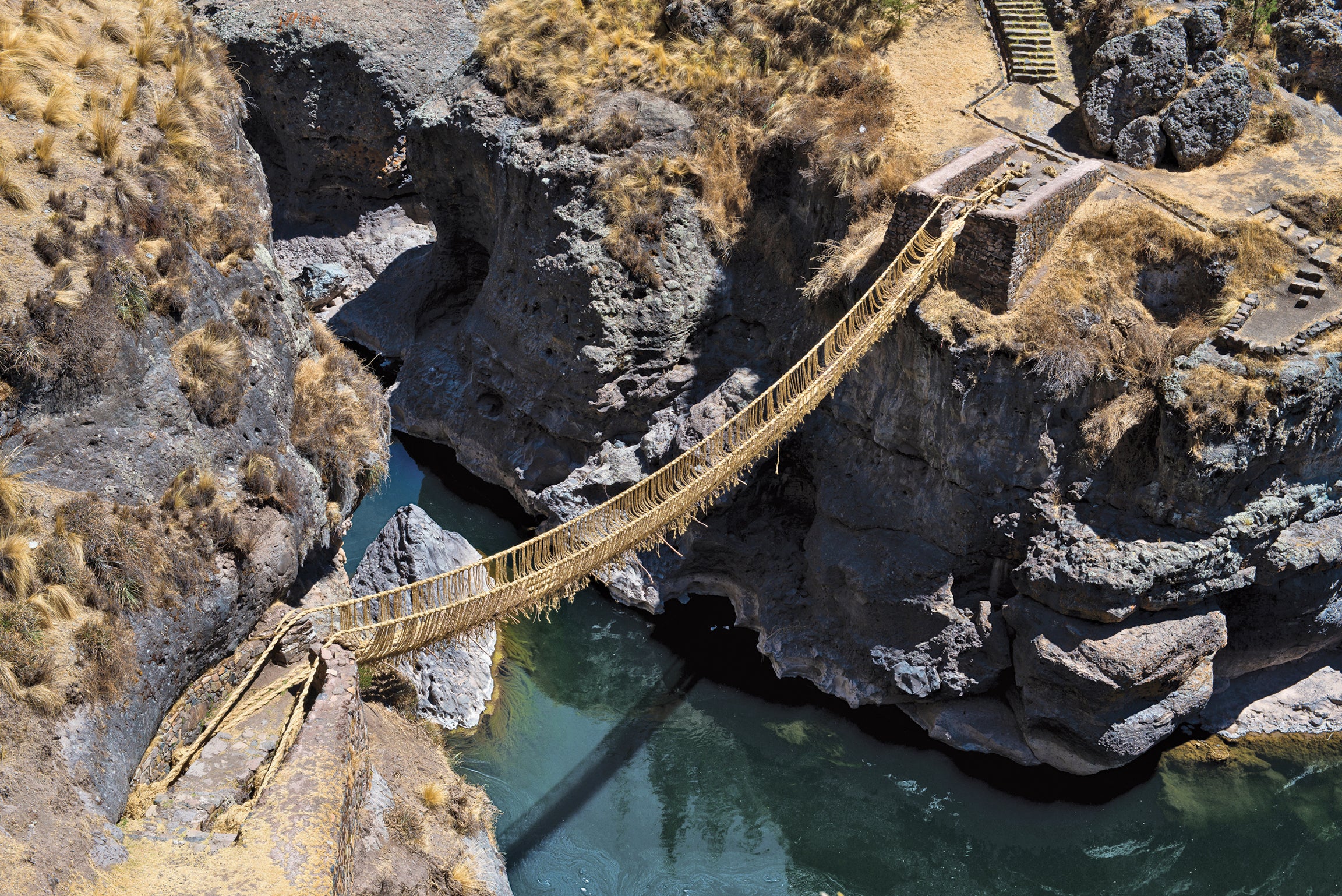
Five centuries ago, the Andes were strung with as many as 200 suspension bridges braided from nothing more than twisted mountain grass and other vegetation, with cables sometimes as thick as a human torso. Three hundred years before Europe saw its first suspension bridge, the Incas were spanning longer distances and deeper gorges than anything the best European engineers, working with stone, were capable of.
Today, there is just one Incan grass bridge left, the Keshwa Chaca, a sagging 90ft (27.4-metre) span that stretches between two sides of a steep gorge, near Huinchiri. According to locals, it has been there for at least 500 years. Despite its seemingly fragile materials, modern load testing has found that in peak condition, the Keshwa Chaca can support the weight of 56 people spread out evenly across its length.
The yearly tradition of rebuilding the Keshwa Chaca has not abated. Each June, it is renewed in an elaborate three-day ceremony. Each household from the four surrounding towns is responsible for bringing 90ft of braided grass cord. Construction takes place under the supervision of the bridge keeper, or chacacamayoc. The old bridge is then cut down and thrown into the river. Because it has to be willfully, ritually regenerated each year, the Keshwa Chaca’s ownership passes from generation to generation as a bridge across not only space, but also time.
Where: The bridge crosses Apurimac Canyon, five hours south of Cusco.
Coordinates: S 14.383056 W 71.493333
Mexico: Cave of the Crystals
Naica, Chihuahua
In 2000, workers at Naica, Mexico’s largest mine, were excavating a new tunnel 1,000ft (305 metres) underground when they broke into an extraordinary cave. This chamber, now known as the Cave of the Crystals, contains some of the largest crystals ever found. Its crisscrossing shards of selenite measure up to 39ft (12 metres) long.
The unusually immense crystals formed over half a million years in water that was a steamy and stable 136°F (57.7°C). These conditions allowed a particular mineral in the cave, anhydrite, to absorb water and transform into gypsum, its lower-temperature, stable form. Gypsum deposits gradually built up, forming the giant selenite crystals. When mining operations began in the area, workers pumped water from the surrounding caves, inadvertently draining the crystal cave and exposing its treasures.
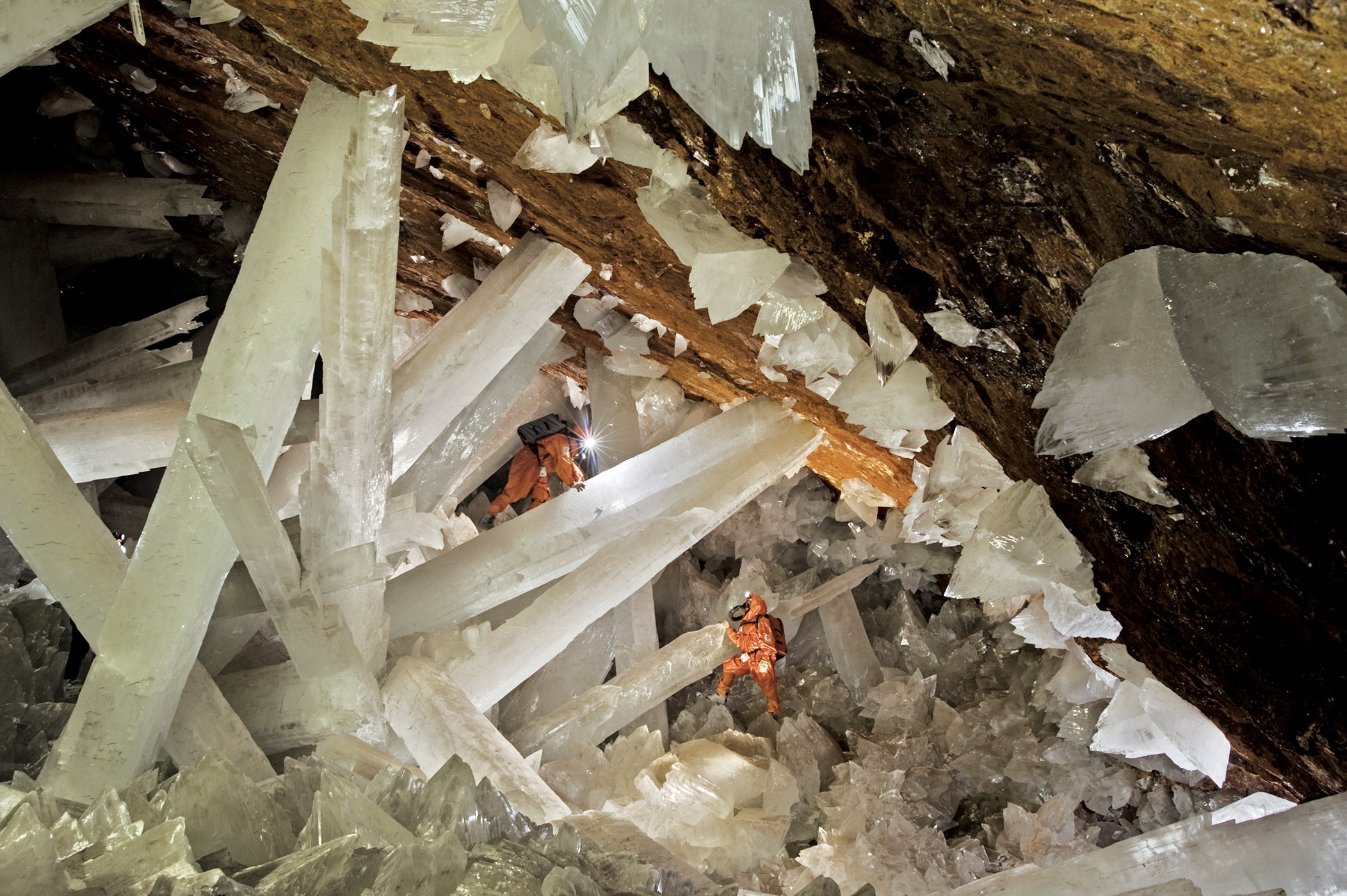
Conditions in the Cave of the Crystals are very hazardous to humans. Ambient temperature is around 125°F (51.6°C), and the 90 to 99 per cent humidity creates a stifling environment in which higher brain functions quickly deteriorate and breathing becomes difficult. The terrain is uneven and the smaller crystals have sharp edges, making walking tough.
Scientists and researchers have been exploring the cave since 2006. They do so wearing cold-water respirators and suits lined with ice. Even with this special equipment, the explorers can only stay in the cave for 45 minutes at a time.
The mine and cave are located in the south-west part of Naica, a town with around 5,000 residents. Due to its fragility and oppressive conditions, the cave is only accessible to researchers.
Where: Terreros 7, Naica. Naica is a two-hour drive south of Chihuahua City.
Coordinates: N 27.850833 W 105.496389
Dominica: Boiling Lake
Roseau
The lake on Watt Mountain is not a good place for a refreshing dip: drinking or bathing in the water will result in death, or at least severe burns. Morne Watt (Watt Mountain) is a stratovolcano, its boiling lake a flooded fumarole — a direct line to the molten subsurface of Earth, with vents pumping scalding steam and gases into the water. A thick cloud of vapour rises from the bubbling blue-grey lake. Water temperature is around 194°F (90°C).
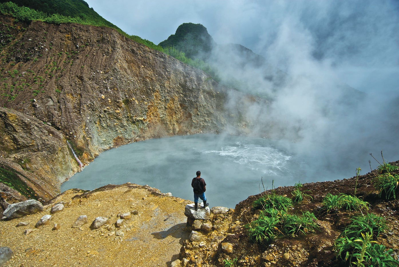
Where: Morne Trois Pitons National Park. You need to be fit to visit the lake — it’s a three-hour hike from the nearest road, over difficult terrain. En route, you’ll pass through the Valley of Desolation, a sulfurous expanse of volcanic vents, hot springs, and bubbling mud.
Coordinates: N 15.333608 W 61.324139
Montserrat: Abandoned Plymouth
Plymouth
On February 11, 2010, vacationers flying from Toronto to St. Lucia on a Boeing 737 heard the pilot make an unexpected announcement: “Ladies and gentlemen, if you look to the left of the plane, you’ll see a volcano erupting.”
The volcano that was indeed hurling a plume of ash into the sky was the Soufrière Hills volcano on the Caribbean island of Montserrat. It was a fantastic sight, but not an uncommon one.
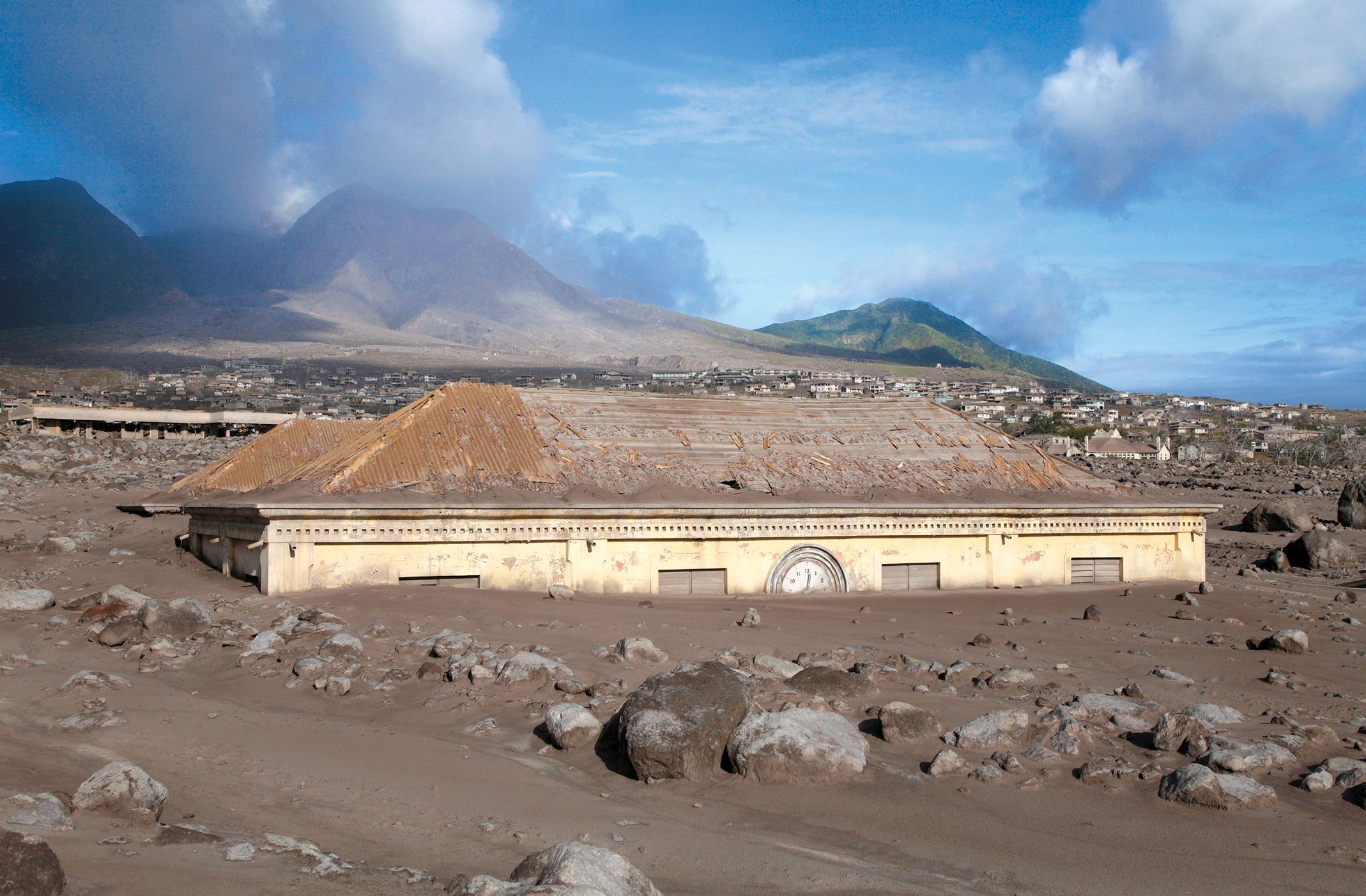
Soufrière Hills began to erupt in 1995 — for the first time since the 17th century — sending lava flows and ash falls over the 10-mile-long (16km) island. The affected areas were evacuated and no one was killed. However, just two years later, the volcano went off again, this time killing 19 people.
Continuing eruptions destroyed the capital city of Plymouth and covered the entire southern half of the island in a thick layer of ash. The south side of the island was declared uninhabitable and remains an exclusion zone.
Over half of Montserrat’s 12,000 residents never returned after being evacuated. Those who stayed live on the north side of the island and have grown accustomed to the ongoing eruptions at Soufrière Hills. The island’s economy is even benefiting from volcano-focused tourism, such as helicopter flights over devastated Plymouth and boat rides offering views of the smoking mound.
Where: Montserrat is a 15-minute plane ride or two-hour ferry ride from Antigua. The southern part of the island is off-limits, but you can see the volcano by boat.
Coordinates: N 16.707232 W 62.215755
US: Fly Geyser
Gerlach, Nevada
These multicoloured, knobby cones of calcium carbonate that spew water from multiple spouts are not natural — humans had a hand in their creation.
In 1964, a geothermal energy company drilled a test well in the Black Rock Desert. The water they encountered was not hot enough to use, so they plugged up the well. But the seal didn’t hold, and water began erupting into the air.
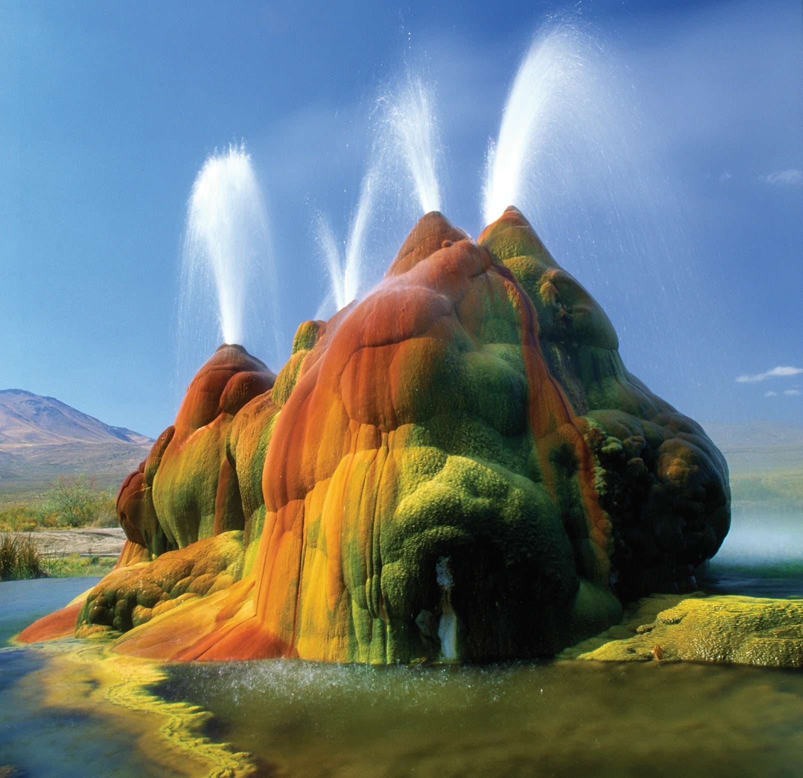
Over the years, the geyser grew as minerals from the water settled on its surface. Fly Geyser and the terraced mound on which it sits now measure 12ft (3.65 metres) tall. Thermophilic algae have turned the cones various shades of green, yellow, orange, and red, giving the geyser a Martian look.
Where: State Route 34, Gerlach. The geyser is on private property but visible with binoculars from State Route 34 near Gerlach. Property owners offer tours a few times a year.
Coordinates: N 40.859318 W 119.331908
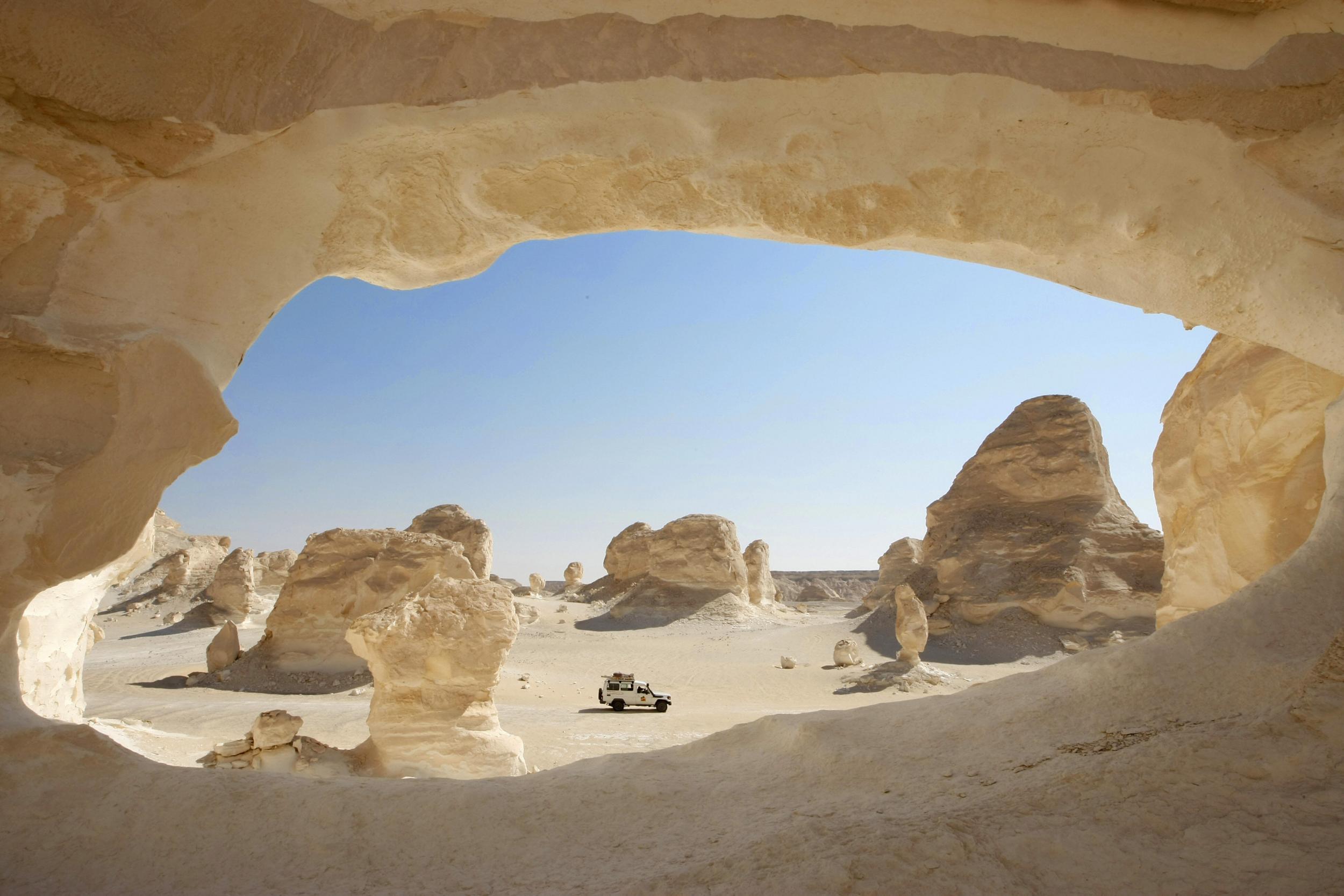
Egypt: White Desert
Farafra, Western Desert
Resembling giant mushrooms, atomic-bomb clouds, and, in one case, a chicken, the limestone rock formations of the White Desert are the heavily eroded remains of a former seabed. During the Cretaceous period, this portion of the desert was underwater, and chalk deposits from the skeletons of marine invertebrates accumulated on the ocean floor. To make a 100-million-year-old story short, the sea dried up, erosion dug odd shapes into the seabed, and now the White Desert is full of weirdly evocative rocks.
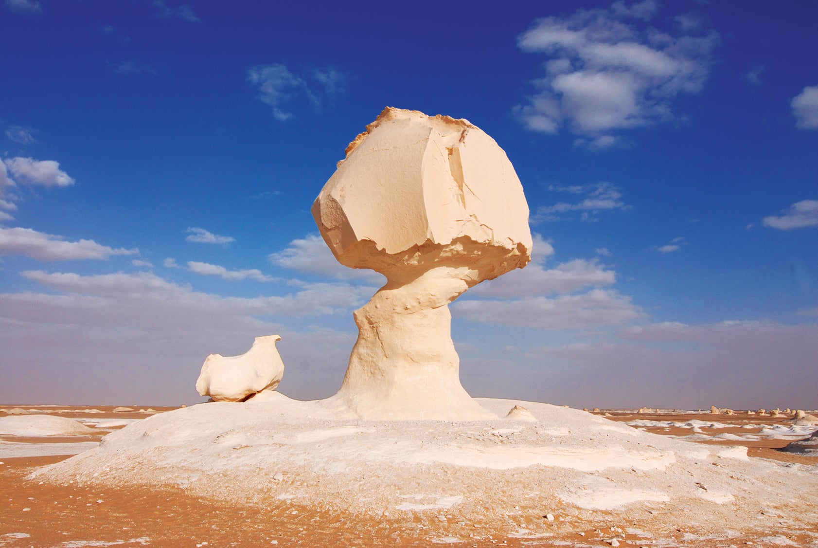
The best way to experience the bleached landscape of the White Desert is to camp overnight. As the sun sets and rises, the light on the rock formations changes, and their shadows morph. In the silence you may hear the soft patter of a fennec’s paws. These adorably large-eared nocturnal foxes are native to the Sahara.
Where: The White Desert is 25 miles (40km) north of Farafra, an oasis where you can take a dip in a hot spring.
Coordinates: N 27.098254 E 27.985839
Extracted from Atlas Obscura: An Explorer’s Guide to the World’s Hidden Wonders by Joshua Foer, Dylan Thuras & Ella Morton (Workman Publishing). £25. Copyright © 2016
Join our commenting forum
Join thought-provoking conversations, follow other Independent readers and see their replies
Comments