Back on the map: Why paper sometimes isn’t enough to help you find your way
You know where you are with a map. Or do you?
The printed map is the centre of attention right now. Last week was, according to the Ordnance Survey, National Map Reading Week. And next week, a blockbuster exhibition opens at the British Library – which, you will see from a map, is adjacent to the adorable St Pancras railway station in London.
Maps and the 20th Century, which begins on 4 November, encompasses the maps that took the world through a century of war, peace and the transformation of travel horizons – from Harry Beck’s first Tube map in 1931, to the Moon landing in 1969.
Yet it might prove to be a wintry retrospective on the summer of peak cartography.
Perhaps like you, I love paper maps. They are both informative and inspirational. Take the Ordnance Survey Landranger sheet 192, entitled Exeter and Sidmouth. I happen to have bought the 2016 edition. Nine pounds, since you ask, more than I remember, but worth it: from the revelation of Devonian place names that sound like forgotten Rep actors (whatever happened to Cheriton Fitzpaine and Manley Thurlescombe?) to the best way to reach Exeter airport, without a plane.
The latter purpose was the motive for buying it.
I was heading for the home of Flybe. Exeter airport is easy to reach by air, but tricky if you are relying on terrestrial public transport, with just one bus an hour from the city. So I bought the latest Ordnance Survey map from Stanfords in Covent Garden, and set off with my bicycle on the morning train from London Waterloo.
When not ram-packed, travelling on South West Trains is a pleasure. The lines from Waterloo south west fan out to all manner of alluring places, with friendly train crews. On a journey last month aboard the stopping service to Windsor, the cheery guard assured passengers that the train would be “calling at all the stations you can think of”.
On the trip to Exeter airport, I took a train that called at all the stations I could think of – and one that I couldn’t.
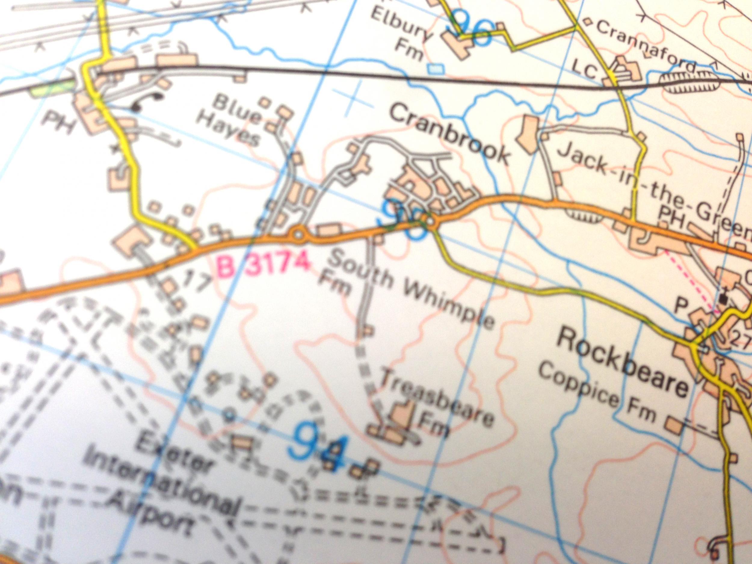
Once you get past Woking and Basingstoke, the stations on the line from the south bank of the Thames to the east bank of the Exe become more lyrical: Templecombe, Sherborne, Crewkerne, Axminster, Honiton, Feniton. My two favourites are almost at the end of the line: Whimple and Pinhoe (or Whimper and Pinhole, as my spell-checker keeps insisting).
The map showed that this poetic pair were the two closest to Exeter airport. Yet when the guard recited the list of stations waiting down the line to delight travellers, he slotted in an extra stop between Whimple and Pinhoe: Cranbrook.
I was disoriented. The map showed a village called Cranbrook, perched on the north side of the airport next to the railway line, but no cerise dot indicating a station. The online timetable, though promised a halt at 11.28am.
On the dot, the train stopped at a station next to a car park beside a housing estate that had sprouted from a village.
I hopped off. I was evidently at Cranbrook station, but as a long-time defender of paper maps against the march of technology, I was also in a quandary. I could possibly have interpreted the location of the station from the contours, a nearby stream and the church tower at nearby Rockbeare, but frankly it was much easier to switch on a mapping app on my smartphone and see where the blue dot placed me. Once I’d been told my coordinates, I went back to the slightly out-of-date 1:50 000 map of east Devon and proceeded happily to the airport.
But I suspect that the typical traveller may prefer an online map that tells them where they were are, advises on the best way to reach their destination and may even warn you how bad the traffic is. So I put it to Tom Harper, the curator of the impending exhibition, that the paper map is now obsolete.
“The one thing that unites maps is that they always have to be useful. If they’re most useful on a phone or in a digital form, that’s how it is. I’m fairly happy with that. But paper maps will continue to outlast any sort of mapping digital form.
“The best way of preserving that geographical content is a paper map.”
Ordnance Survey’s peak year for maps was 2004, when the organisation sold 8,000 a day. Last year, daily sales were still above 5,000, and rising slightly. Compared with, say, music CDs (down 80 per cent since a peak in 2000), that’s a creditable performance.
Join our commenting forum
Join thought-provoking conversations, follow other Independent readers and see their replies
Comments
Bookmark popover
Removed from bookmarks