Scotland: Take a hike through Neverland
Peter Pan author JM Barrie was born in a Scottish landscape that is far from fairy tale, says Mark Rowe
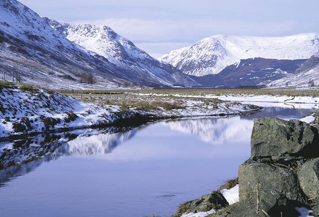
As the chill hand of autumn tightens its grip, at least in Scotland, the Cairngorms become a mournfully magnificent location.
This is a superb walk, though a long one, which takes in a magnificent ridge high above Glen Clova, one of the five valleys that make up the Angus Glens north of Dundee. Some deciduous trees will be hanging onto their leaves but the conifers remain robust; fence posts make vantage points for buzzards or tiny wrens, and look to the high ridges and you may spot one of the Glen's two pairs of golden eagles. Most of the route is on paths and roads and is walkable in all but the most dismal of conditions. Another attraction is that the Glen is just 10 miles north of Kirriemuir, birthplace of Peter Pan author, JM Barrie. Next year sees the 150th anniversary of Barrie's birth, which will be celebrated with a programme of special events in and around this old market town.
The walk begins at the Clova hotel in the small village of Clova. Follow the eastern arm of the B955 for 1.3 miles until you reach Marchburn cottage. Here, walk through the weathered gate and head across the field (there's no path) to the bridge, using a stile to cross an electric fence. The bridge crosses the River South Esk and you then bear left following the purple routemarkers along the field edge, turning right uphill to reach the road. Here, turn left and walk for 1.9miles along the road, passing the boundary stone signalling you are leaving the Cairngorms National Park. To the east are the classical, glacial pudding basin hills, ground out and smoothed down during the last Ice Age.
Shortly after passing Wester Eggie House, bear right following the sign for the Minister's Path for Glen Prosen. Go over the stile and follow the broad track through the forest, ignoring a path after 300 yards and keeping ahead to pass through a gate.
Take either of the two paths in front of you (they merge further up the hill) and wind your way up the heather moorland, the wonderful ridge walk lined up tantalisingly to the south. The path weaves back and forward making for the fence line. At a fingerpost sign keep ahead, signpost Glen Prosen, and pass a hut on your left.
Shortly after the path moves away from the fence it splits and you take the unsigned left-hand turn making for the ridge. This path is marked on the Explorer OS map but not the Landranger.
Follow the grassy path as it winds its way past the grouse butts up and over Cairn Leith keeping the fence on your left and drop down to a fence that cuts across the path at right angles to pick up the stony track as it climbs the Hill of Balbae.
The path drills directly along the Sneck of Lapshalloch and up the Hill of Couternach – at 512m (1,679ft), the highest point of this walk – before making for the Craigs of Lethnot. You'll get glimpses of the Airlie monument, a sandstone tower, conspicuously perched on a hilltop in the middle distance. The path drops down across the Sneck of Corinch and up once again to an unnamed summit, with glimpses of the sea to the east beyond Arbroath. Here the path and fence turn left, headed for the hilltop known as The Goal. Just before reaching it you cross a fence by a stile and briefly bear left along a thin path flanked by heather before turning right to rejoin the fence path. After 300 yards turn right and follow the path (the fence again on the left) as it makes for the Airlie monument, dropping downhill into woods.
Keep ahead, either via the gate or ladder stile, and then exit the woods through a large gate and follow the grassy path up to the Airlie monument. The tower, fitted with mock cannons, is not a folly but a monument from the present Earl of Airlie to his grandfather, who died in the Boer War.
Follow the path downhill into the pine forest as it snakes its way through the canopy. When you reach a second waymarker, the path splits and you keep ahead, taking the left-hand track. Follow the yellow waymarkers as they wind back and forth through the forest for half a mile before finally emerging by magical, lonely Cortachy cemetery.
Follow the paved lane and bear off taking the yellow waymarkers again, to eventually drop down to the road where a path continues along the verge for 400 yards before you follow the road to the walk's end, in Dykehead.
Compact Facts
Distance: 13 miles
Time: Five–six hours
OS map: OS Explorer 388, Lochnager, Glen Muick and Glen Clova and OS Explorer 381, Blairgowrie, Kirremuir and Glamis.
Getting there
Mark Rowe stayed at Glen Clova hotel (01575 550350; clova.com) with rooms from £90 B&B. This walk was recommended by Jane Andrews of Glentrek (01575 570801; glentrek.com) a company offering guided walks in the Angus Glens.
Crosscountry trains (crosscountrytrains.co.uk; 0844 811 0124) operates services to Dundee. From here the best option is to hire a car. Glen Clova is very remote; you'll need transport back to your accommodation at the end of this walk.
Further information
For more walking ideas visit visitscotland.com/whiteinvite
Join our commenting forum
Join thought-provoking conversations, follow other Independent readers and see their replies
Comments
Bookmark popover
Removed from bookmarks