Met Office finally gives verdict on ‘African plume’ heatwave
Forecasters say those anticipating period of sunny and warm conditions will be in luck

The Met Office has dismissed reports predicting a UK heatwave driven by an African plume as “hyperbole”.
Some forecasts had indicated the weather phenomenon, characterised by a mass of hot air originating from the Sahara desert, was likely to sweep across Europe between June and September.
African plumes can bring extended periods of hot weather, with the potential for temperatures 30C and higher.
However, the Met Office has said that while Britain will see warm conditions of 20C or above this week, anything more than that is an exageration.
“If you have heard media hyperbole that a heatwave driven by an African plume will bring intense heat to the UK in the next few days, you are going to be disappointed – this isn't true,” said Neil Armstrong, chief forecaster at the Met Office.


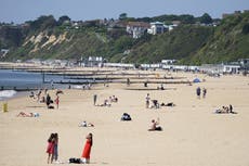
However, he added that those anticipating a period of mostly fine, sunny, and warm conditions across the majority of the UK will be in luck.
The Met Office said temperatures will gradually rise through the week, with an expected high of 24C, possibly 25C, by Thursday.
The forecast for Wednesday indicated a band of thicker cloud with light rain or drizzle moving south across Scotland and Northern Ireland.
The rest of the UK is expected to remain dry with warm sunny spells, although the far north might experience stronger winds.
Wednesday night will bring clear spells for most areas, while a fragmented band of thicker cloud continues its southward movement.
Thursday is forecasted to be dry with variable cloud amounts and sunny spells. Daytime temperatures will feel warm, but overnight temperatures may become chilly, leading to the possibility of local fog patches under clear spells.
These temperature highs are expected to be in parts of East Wales, West Midlands, and South West England.
An onshore breeze will keep temperatures slightly lower in the south east of England, where usually the highest temperatures are seen.
With this forecast, people can expect a warm and sunny bank holiday weekend ahead. But there might be cloudier conditions and patchy rain in the northwest at times.

MET OFFICE OUTLOOK
Wednesday:
Dry for most with clear spells, a fragmented band of thicker cloud continues to move south. Locally chilly where skies remain clear.
Thursday:
Dry with variable amounts of cloud and sunny spells, feeling warm by day, but chilly overnight with some localised fog patches possible under clear spells.
Outlook for Friday to Sunday:
Remaining largely settled this week with further warm sunny spells. Cloudier in the northwest at times with patchy rain. Chilly overnight with some fog patches. Cooler near eastern coasts.
Join our commenting forum
Join thought-provoking conversations, follow other Independent readers and see their replies
Comments
Bookmark popover
Removed from bookmarks