New Year’s Eve partygoers face weather chaos as 75mph winds and heavy rain to batter UK
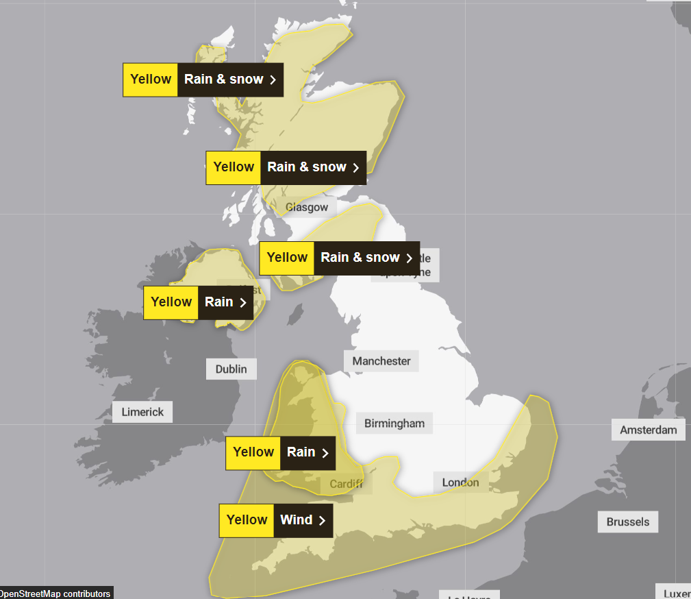
A yellow weather warning is in place for wind and rain throughout Saturday and Sunday
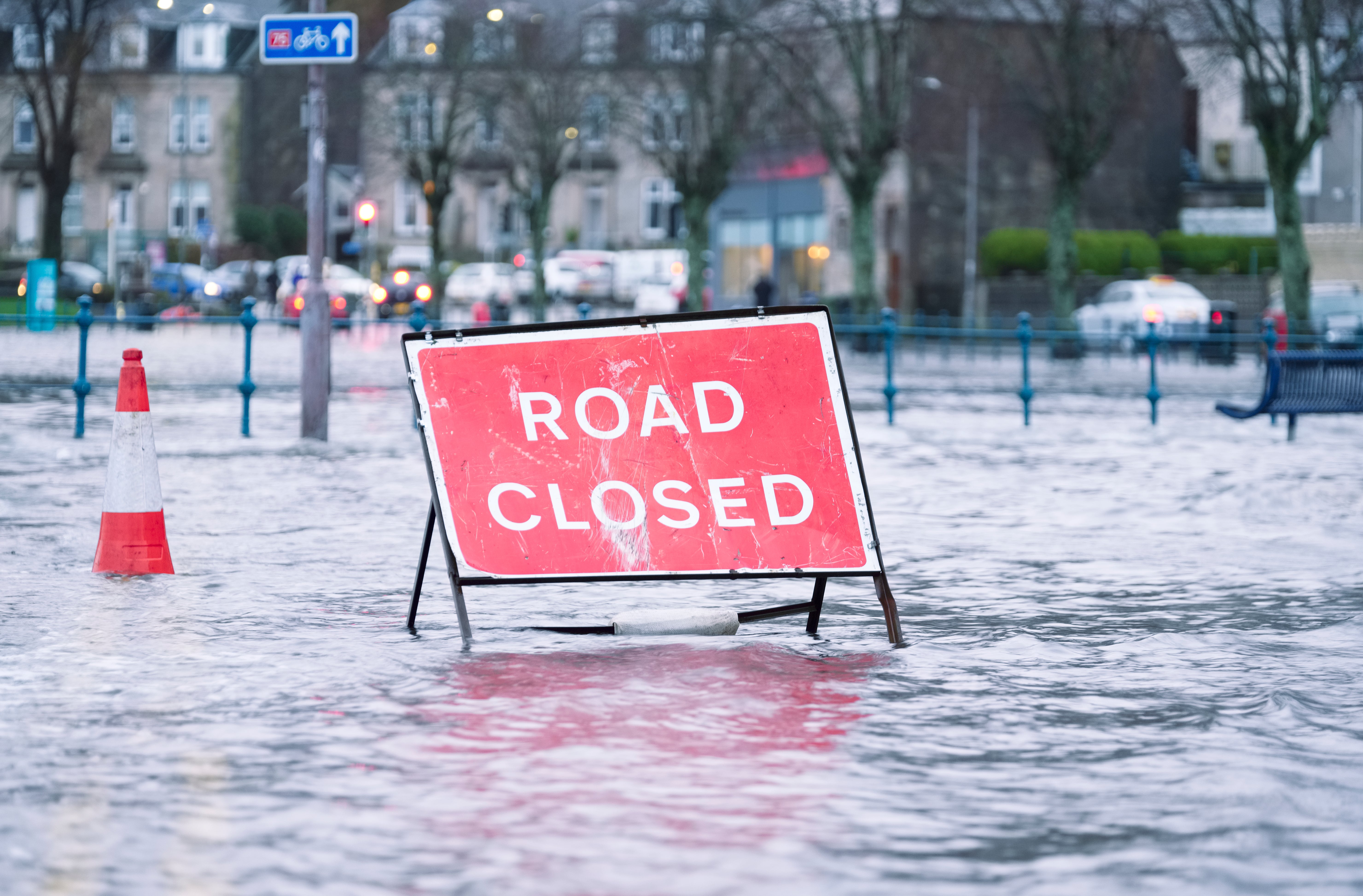
Partygoers celebrating New Year’s Eve are likely to face heavy rain and potential snow, as the UK continues to reel in the aftermath of Storm Gerrit.
As millions ring in the start of 2024, people face damp fireworks displays as rain and wind batter the coastline areas and temperatures drop to near freezing.
With midnight approaching, the Met Office said Scotland is likely to see icy conditions develop, while up to 25mm of rain is expected to batter Wales and Northern Ireland.
Ahead of New Year’s Eve, a cold front is set to move east across England and Wales on Saturday, with a weather warning in place until 3am on Sunday morning as winds are expected to reach up to 75mph in places near the south-west coast.
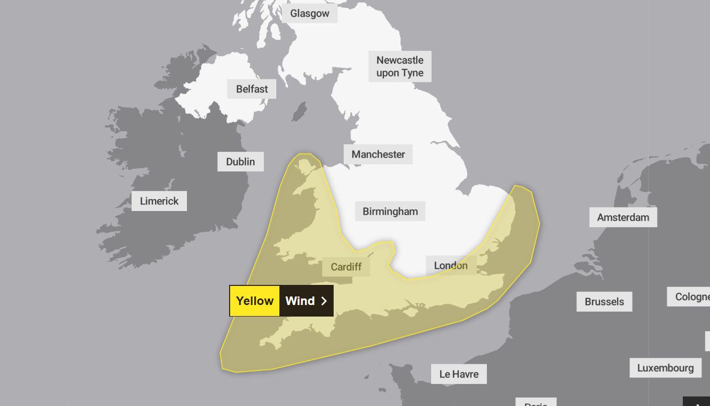
The warning, which is in place from 11am on 30 December until 3am the following day, is expected to bring delays to road, rail, air and ferry transport, with it likely that some coastal communities and sea fronts in south Wales and Cornwall will be affected by large waves.
Some train services are likely to be impacted as well as short-term loss of power and delays for high-sided vehicles.
It comes after Storm Gerrit left thousands of homes without power on Thursday, with a lightning strike impacting 36,000 properties in Wales and 1,500 homes in northern Scotland enduring two nights with no electricity.
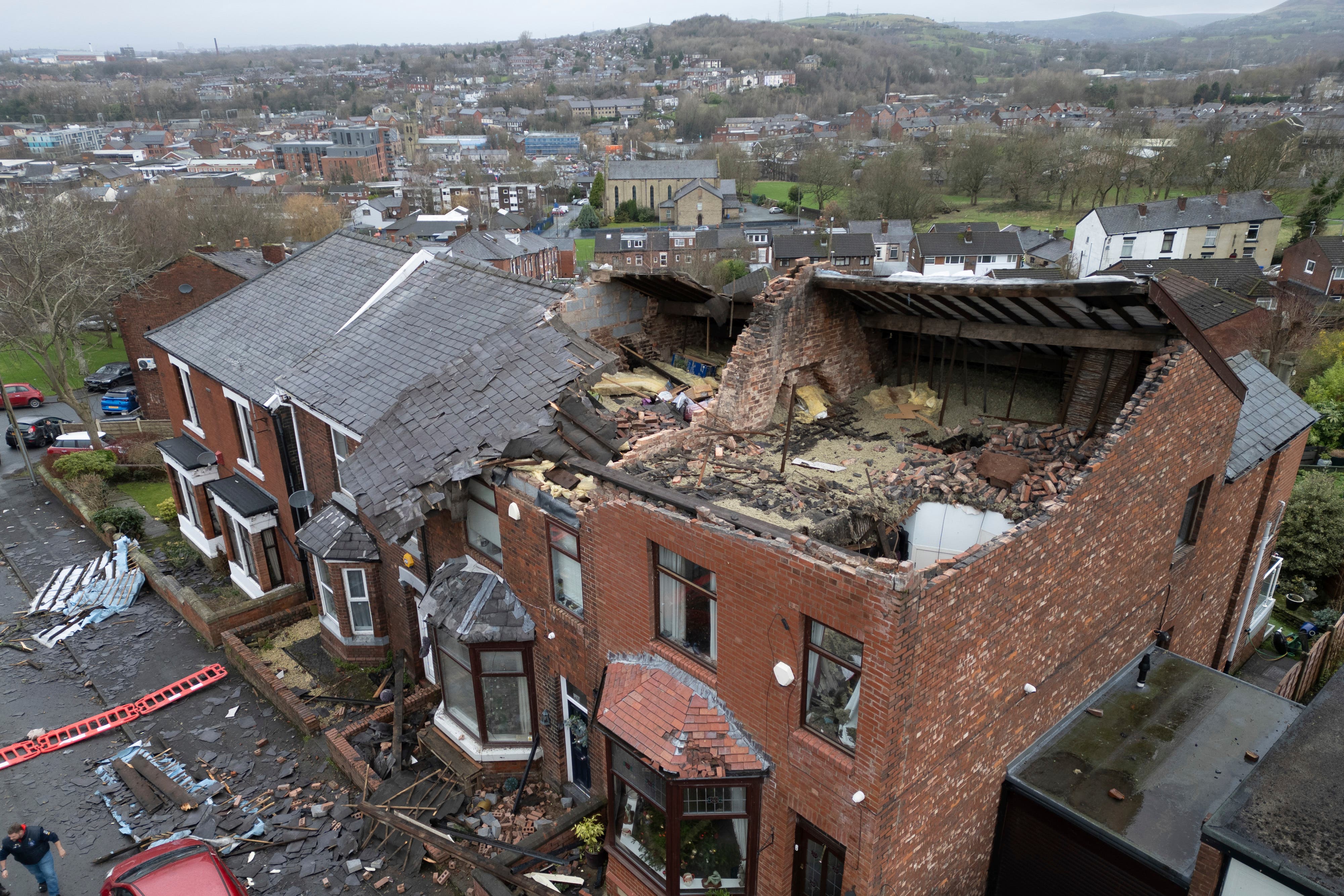
A “localised tornado” also tore through Greater Manchester on Wednesday evening, damaging 100 houses and tearing down trees.
Speaking to The Independent, senior meteorologist Rachel Ayers said: “Rain that will spread northeastwards on Saturday will clear away from the Northern Isles with some very windy conditions here to start.
“Elsewhere it will be a mixture of sunny spells and blustery showers that could band together at times. Some of these showers could be thundery with hail mixed in especially in the south/southwest.
“A very windy day in the south/southwest too with gales or even severe gales along the south coast with strong gusts inland in and around showers.
“Looking at the weather closer to midnight showers will become more isolated though could still band together and winds will generally start to ease though gale force winds are still possible for western and southern coasts. There is also a risk of ice developing overnight for some higher roads in Scotland.”
Temperatures are expected to drop to near freezing, reaching just 1C in the Scottish Highlands and 3C in Edinburgh.
Andy Page, a forecaster for the Met Office, said: “Parts of the higher ground of Scotland may see temporary snow accumulations of 5-10cm, while up to 25mm of rain is expected in Wales, Northern Ireland and lower levels in Scotland.
“Across Wales and southern England wind gusts of 45-50mph are likely to be quite widespread, while gusts of 65-75mph are possible in the most exposed coastal areas.”
Meanwhile, train operators have encouraged revellers to travel as early as Friday to avoid disappointment with rail cancellations in the wake of the bad weather and staff shortages.
Passengers due to travel on Northern Rail have been told that tickets booked for Sunday are valid from Friday and have been warned to “expect disruption” on New Year’s Eve.
Other railway services such as Chiltern Railways, which operates from London Marylebone, and CrossCountry, which operates throughout the UK, have warned of last minute cancellations.
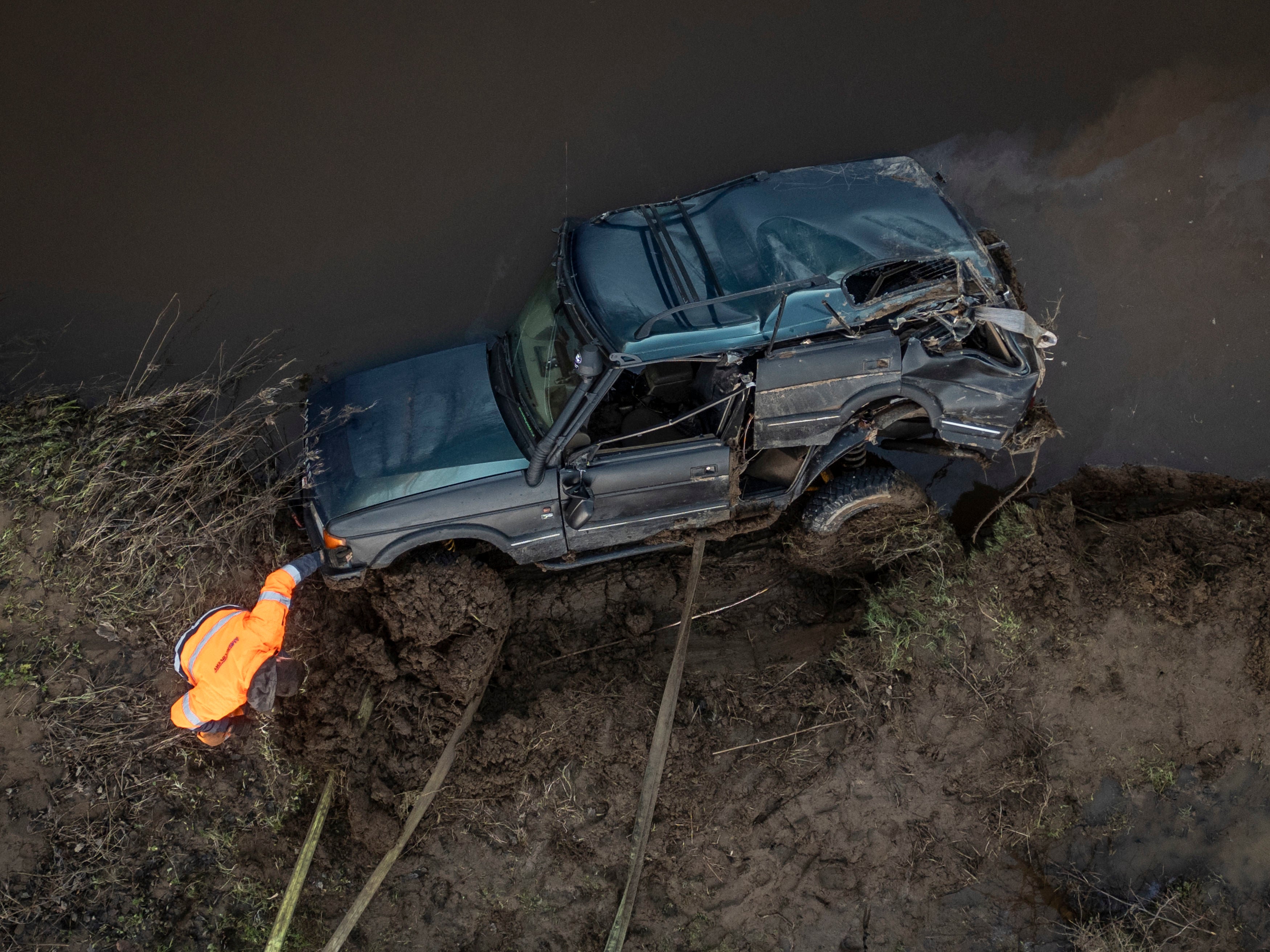
With unsettled conditions due to continue impacting the UK post-Storm Gerrit, people have been encouraged to check the forecast before travelling and to avoid driving through flood water. This comes as three men were killed after their 4x4 became submerged in the River Esk on Thursday.
An Environment Agency spokesperson said: “The Environment Agency is monitoring closely and has teams out on the ground undertaking preparatory activity to minimise the impacts of flooding where possible.
“At this time of year, with people out walking over the festive and New Year period, it’s particularly important to take care near riverbanks. If you are planning on travelling, please check the weather conditions ahead of your journey, and we urge people not to drive through flood water as just 30cm of flowing water is enough to move your car.”
Looking ahead into 2024, Met Office Deputy Chief Forecaster Nick Silkstone said: “Through to mid-January, there is a signal for a shift in the pattern compared to the winter so far, with more settled and colder-than-average conditions becoming increasingly likely.”
Join our commenting forum
Join thought-provoking conversations, follow other Independent readers and see their replies
Comments
Bookmark popover
Removed from bookmarks