UK weather warnings: Met Office issues ‘danger to life’ alert over Storm Antoni 65mph winds
Strong winds and rain could cause dangerous flooding, with debris from damaged buildings potentially posing a risk of fatal injury, forecasters warn

The first Met Office-named storm of the year will hit the UK this weekend, with gusts of up to 65mph expected to batter the coast while strong winds and heavy rain will disrupt travel and could pose a “danger to life”.
The national forecaster warned that Storm Antoni could also bring winds of up to 50mph inland in parts of south Wales and southwest England, while heavy rains could flood homes and businesses in Northern Ireland.
“Unseasonably” strong winds and fast-flowing rainwater may disrupt air, rail, road and ferry travel, with the potential to put lives at risk as the low-pressure weather system moves in from the Atlantic Ocean, meteorologists said.
The RAC warned of “atrocious” conditions for drivers on what will be “the worst day on the roads of the summer so far”, as it urged motorists to avoid exposed routes until the storm passes.
Follow The Independent’s live coverage for the latest updates
It is the first storm to be named by the Met Office in the 2022-23 season, and comes just four weeks before the season is due to end. In February and April, the names Otto and Noa – chosen by overseas weather agencies – were adopted by the Met Office as those storms hit the UK.


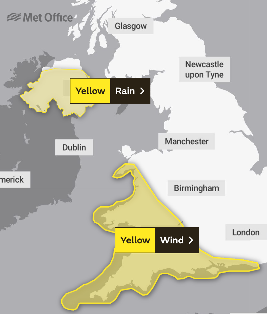
Two weather warnings will be in force on Saturday, with a yellow alert for rain covering most of Northern Ireland from midnight until 11am. Up to 60mm of rain could fall in Northern Ireland in a single day – comprising nearly three-quarters of Belfast’s average monthly total.
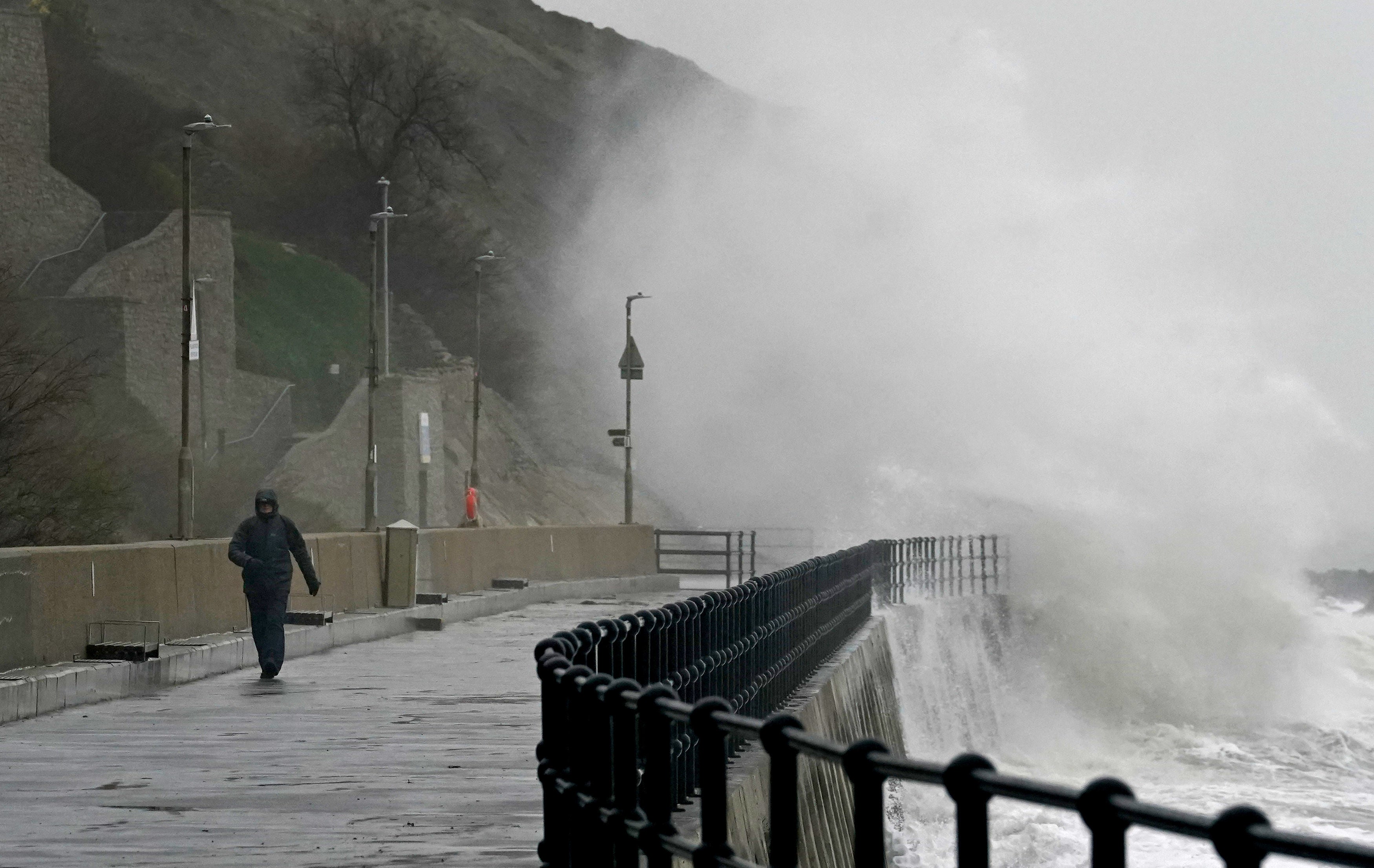
A second warning issued across southwest England and much of Wales will be in place for 12 hours until 8pm, and cautions that strong winds could cause some damage to buildings, with flying debris posing a potentially fatal risk of injury.
Road, rail, air and ferry services could be affected by the winds, with longer journey times and cancellations possible along with road and bridge closures, the Met Office said, warning that “injuries and danger to life could occur from large waves and beach material being thrown onto sea fronts, coastal roads and properties”.
Power cuts may also occur, with the potential to affect other services such as mobile phone coverage, forecasters said.
Met Office chief meteorologist Steve Willington said: “Storm Antoni will bring some potentially disruptive weather on Saturday as it moves from west to east. Northern Ireland is likely to see some of the highest rainfall totals, with 40-60mm falling in some spots but 20-30 more widely.
“Away from the warning area, many will still see a very wet day, especially in north Wales and northern England.
“Storm Antoni will also bring strong winds to a swathe of Wales, southwest England and southern coastal areas of England. The strongest winds will affect parts of southwest England and southwest Wales, where exposed coasts and high ground could see gusts in excess of 60mph.
“In these areas, gusts inland could reach 50-55mph for a time. These windy conditions will likely coincide with high tides, which will present an additional challenge for coastal areas.
“Busy travel networks at this time of year and the possibility of people having made plans to be outside have resulted in the system meeting our criteria for naming, with a strong chance of disruption for those within the warning areas.”
Follow The Independent’s live coverage for the latest updates
The RAC warned of “atrocious” and “wholly unpleasant” conditions for drivers, as it urged motorists to “slow down significantly”, look out for fallen trees, and avoid exposed moorland and coastal routes until the storm has passed, with 4 million people expected to make leisure trips this weekend.
After a month of largely unsettled weather for the UK, there are some tentative signs of a change, albeit perhaps only briefly, later next week, forecasters said.


Mr Willington added: “For the latter half of next week, there are some signals of a shift in the jet stream, which may allow for high pressure to build in for southern areas of the UK, increasing the likelihood of some drier weather for a time.
“However, at this range the details are quite uncertain, and there’s still a chance of some rain for areas further north. As always, details will become clearer with a shorter lead time.”
Join our commenting forum
Join thought-provoking conversations, follow other Independent readers and see their replies
Comments
Bookmark popover
Removed from bookmarks