UK weather: Heavy rain warnings for three days as snow gives way to downpours
Flight cancellations, power cuts and flooding possible, Met Office warns
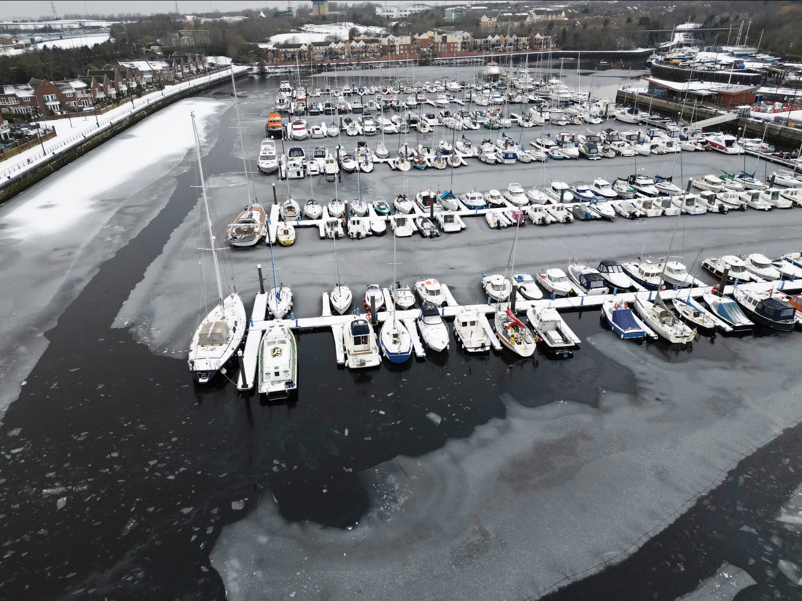
Forecasters have warned of a “potent mix of wintery hazards” in the final week before Christmas, as the icy blast of Arctic air which has covered the UK in ice and snow gives way to warmer temperatures and downpours of up to 150mm.
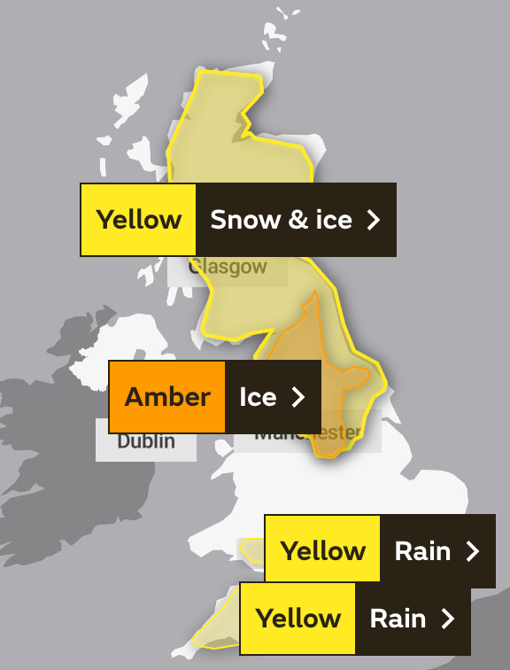
Weather alerts have been issued across much of the country, with the majority of England’s southernmost counties and parts of south Wales warned of heavy and persistent rain, which will pose a risk of flooding and travel disruption until at least Tuesday morning.
Further north, a more severe amber alert is in force on Sunday, as the Met Office cautions that a period of “freezing rain” and snow will bring a strong chance of power cuts – potentially affecting mobile phone coverage – as well as rail and flight cancellations and delays, and a danger to life due to slips, falls and road collisions.
This warning covers the majority of northern England, excluding the coasts and northeast, stretching from well below Sheffield in the south to Cumbria and parts of Northumberland, lasting until 8pm.
Those parts of northern England escaping the amber alert, however, face a less extreme warning for snow and ice, which extends all the way up to the north coast of Scotland and raises the possibility of falls, power cuts, travel disruption and rural communities becoming cut off.


“While the northerly airflow and cold conditions that have dominated our weather in recent days are coming to a close, there’s a potent mix of wintery hazards on Sunday which has resulted in several warnings being issued,” said Neil Armstrong, chief meteorologist at the Met Office.
“As this milder air from the south moves north, there’s a continued chance of snow, even to low levels, in the north of the UK. Freezing rain, which is a relatively rare phenomenon in the UK, is likely to impact areas near the Pennines and could result in some power interruptions and travel disruptions.
“Within the Amber warning area, freezing rain could lead to the build up of 2-3mm of ice on untreated surfaces, which is likely to cause treacherous travel conditions and road closures.”
Conditions are expected to remain unsettled next week, with some strong winds and prolonged periods of rain, the Met Office said – warning that an excess of 150mm of rain is possible on high ground in Dartmoor and between 30 and 80mm more widely within the southern areas impacted by the alert until Tuesday.
The Environment Agency has warned that flooding is possible in 15 areas, mostly near rivers in Dorset, Devon and Cornwall, as well as the River Maun in Nottinghamshire. The agency is urging residents to be prepared – with the worst expected overnight and into Monday in most affected areas.
This week saw temperatures plunge as low as -17.3C, with forecasts recording what they believe was the coldest day since 2010 – as temperatures failed to rise above -9.3C for 24 hours on Monday in Braemar, a village in the Scottish Highlands.
While the mercury sat as low as -8 in Aberdeen and -4 at Heathrow on Sunday morning, it had risen to 5C and 2C by lunchtime respectively, with much of the UK set to enjoy temperatures in the low-teens as we enter the final week of Advent on Monday.
Prior to that, however, the UK Health Security Agency’s (UKHSA) second-strongest cold weather alert remains in force until midnight, and people are urged to look out for friends and family who may be vulnerable to the cold, ensure they have access to warm food and drinks, and are managing to heat their homes adequately.


“Cold weather can have serious consequences for health, and older people and those with heart or lung conditions can be particularly at risk,” said Dr Agostinho Sousa, a consultant in public health medicine at the UKHSA.
“If you have a pre-existing medical condition, you should heat your home to a temperature that is comfortable for you. In rooms you mostly use such as the living room or bedroom, try to heat them to at least 18C if you can.
“Keep your bedroom windows closed at night. Wearing several layers of clothing will keep you warmer than one thicker layer.”
Join our commenting forum
Join thought-provoking conversations, follow other Independent readers and see their replies
Comments
Bookmark popover
Removed from bookmarks