UK weather: Ten-hour thunderstorm warning with risk of lightning strikes today
Properties could experience flooding and damage from lightning, Met Office warns
A 10-hour thunderstorm warning has been issued across parts of England and Wales.
Areas in the South West, Midlands and Wales have been told to expect heavy showers, lightning and hail on Thursday.
The Met Office has imposed a yellow weather warning - which says disruption is likely - until late evening.
It stretches from Stoke-on-Trent through Birmingham and Bath down to Plymouth and Salisbury in southern England.
The warning also covers most of Wales, including Cardiff.
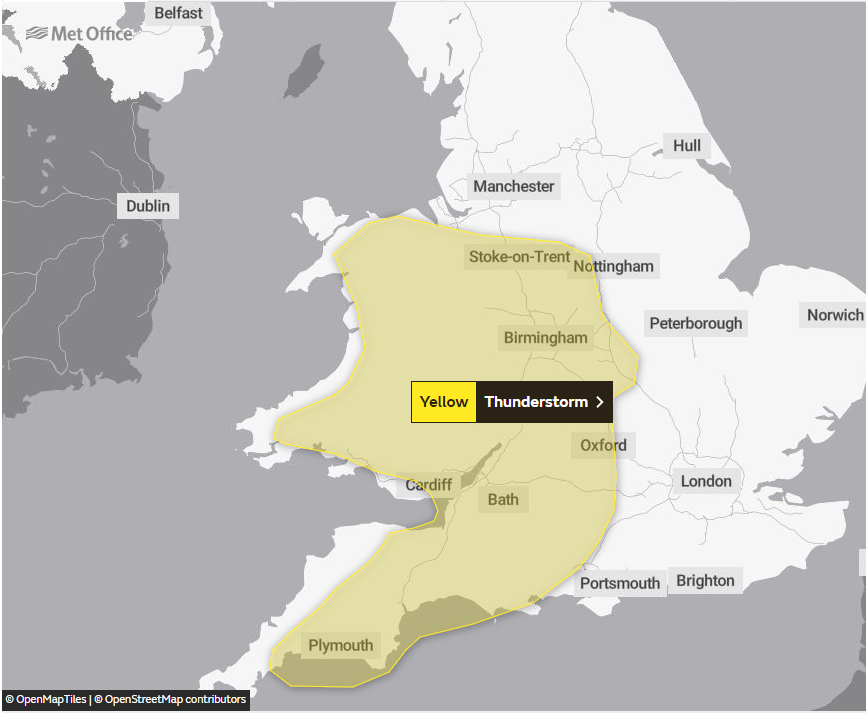
The Met Office said these places could see power cuts and travel disruption due to weather conditions.
Forecasters said properties could be flooded or face damage from lightning strikes on Thursday.
The yellow weather warning came into force from midday and runs until 10pm.
It comes nearly two weeks after areas in southern England were told to stay indoors over a “huge cluster” of thunderstorms.
The Met Office has told the UK to expect unsettled weather over the next few days, with scattered showers and sunny spells forecast across the country.

Forecasters has also warned there could be another heatwave in a matter of weeks as conditions start to ease.
The UK basked in scorching temperatures earlier this month, when the hottest day of the year was recorded several days in a row.
“Things should start feeling fairly warm as we go into the middle of July,” Dan Stroud, a Met Office meteorologist, told The Independent.
He added: “Whether we get a heatwave at this point really depends on the exact wind directions and orientation to that area of high pressure.”
MET OFFICE OUTLOOK
Today:
Sunny spells, but showers in the north and west at first, some heavy and slow moving, then developing elsewhere through the day. Risk of isolated thunderstorms and hail, particularly in southern and central parts later.
Tonight:
Areas of heavy showers over central England moving into parts of northeast England, else clear intervals and a few showers in the south and west.
Friday:
Another day of sunshine and showers, although some more persistent rain possible in northeast Scotland in the morning, then over Northern Ireland later.
Outlook for Saturday to Monday:
An unsettled weekend of sunny spells and scattered showers, occasionally heavy, mainly in the north and west. More settled from Monday with any rain becoming confined to the northwest.
Join our commenting forum
Join thought-provoking conversations, follow other Independent readers and see their replies
Comments
Bookmark popover
Removed from bookmarks